

Weather Xtreme: A Few Strong Storms Possible This Afternoon, Typical Summer Weather Returns on Sunday
The Central Alabama Weekend
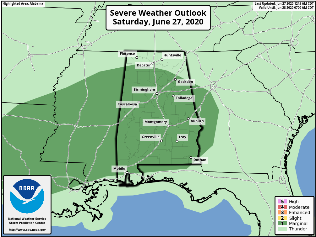
A shortwave will move through the area during the morning and afternoon hours on Saturday that will keep our rain chances elevated. A few scattered showers and thunderstorms will be possible during the morning hours, but those will become more numerous as we get into the main heating of the day. A few storms may become strong and possibly briefly severe, and for this reason, the Storm Prediction Center has most of Central Alabama in a Level 1 Marginal Risk for severe storms. Isolated damaging wind gusts up to 60 MPH and isolated large hail up to one inch in diameter (golf ball size) are the main threats, with the main window for stronger storms from 1:00 pm to 9:00 pm.
HIGHS: middle 80s to the lower 90s.
We return back to a more typical summertime weather pattern for Central Alabama on Sunday. We’ll have a mix of sun and clouds with the typical chance of scattered showers and thunderstorms mainly during the afternoon hours.
HIGHS: upper 80s to the lower 90s.
The Work Week Ahead
Not much change to the forecast on Monday as it will start to sound like a broken record. We’ll have a good bit of morning sun with convective clouds starting to build as we approach the afternoon. A few scattered showers and thunderstorms will be possible mainly during the afternoon.
HIGHS: upper 80s to the lower 90s.
Tuesday will be a carbon copy of Monday’s weather… Mostly sunny in the morning but becoming partly cloudy by the afternoon with a chance of a few scattered showers and thunderstorms.
HIGHS: upper 80s to the lower 90s.
The rinse and repeat forecast continues on Wednesday… We’ll have a mix of sun and clouds with a few scattered showers and thunderstorms mainly during the afternoon hours.
HIGHS: middle 80s to the lower 90s.
On Thursday, it’s the same story on a different day… We’ll have a good bit of morning sun with convective clouds starting to build as we approach the afternoon. A few scattered showers and thunderstorms will be possible mainly during the afternoon.
HIGHS: middle to upper 80s.
By now, you would think Pete The Repeat Parrot would be doing the forecast as Friday’s weather looks to be the same as the rest of the workweek. Skies will be mostly sunny in the morning but becoming partly cloudy by the afternoon with a chance of a few scattered showers and thunderstorms.
HIGHS: middle to upper 80s.
The Tropics

Tropical cyclone formation is not expected during the next 5 days across the North Atlantic, Caribbean Sea, and the Gulf of Mexico.
On This Date in Weather History
1901 – There was a rain of fish from the sky at Tiller’s Ferry, SC. Hundreds of fish were swimming between cotton rows after a heavy shower.
1957 – Hurricane Audrey smashed ashore at Cameron, LA, drowning 390 persons in the storm tide, and causing 150 million dollars damage in Texas, Louisiana, and Mississippi. Audrey left only a brick courthouse and a cement-block icehouse standing at Cameron, and when the waters settled in the town of Crede, only four buildings remained. The powerful winds of Audrey tossed a fishing boat weighing 78 tons onto an off-shore drilling platform. Winds along the coast gusted to 105 mph, and oil rigs off the Louisiana coast reported wind gusts to 180 mph. A storm surge greater than twelve feet inundated the Louisiana coast as much as 25 miles inland. It was the deadliest June hurricane of record for the U.S.
Beach Forecast Center
Get the latest weather and rip current forecasts for the beaches from Bay St. Louis, MS, to Panama City Beach, FL, on our Beach Forecast Center page. There, you can select the forecast of the region that you are interested in.
Advertise On The Blog!
We had another fantastic year in 2019 with just over 17 million page views! That brings our total for the last 2 years close to 37 million page views! Don’t miss out! We can customize a creative, flexible, and affordable package that will suit your organization’s needs. Contact Bill Murray at (205) 687-0782.
E-Forecast
Get the Alabama Wx Weather Blog’s Seven-Day Forecast delivered directly to your inbox by email twice daily. It is the most detailed weather forecast available in Central Alabama. Subscribe here… It’s free!
Connect With The Blog On Social Media
You can find the AlabamaWx Weather Blog on the major social media networks:
Facebook
Twitter
Instagram
Category: Alabama's Weather, ALL POSTS, Severe Weather, Tropical, Weather Xtreme Videos
About the Author (Author Profile)
Scott Martin is an operational meteorologist, professional graphic artist, musician, husband, and father. Not only is Scott a member of the National Weather Association, but he is also the Central Alabama Chapter of the NWA president. Scott is also the co-founder of Racecast Weather, which provides forecasts for many racing series across the USA. He also supplies forecasts for the BassMaster Elite Series events including the BassMaster Classic.Subscribe
If you enjoyed this article, subscribe to receive more just like it.


