New Advisory Issued for Invest 92L, Now Known as Potential Tropical Cyclone Nine
SUMMARY OF 1100 AM AST…1500 UTC…INFORMATION
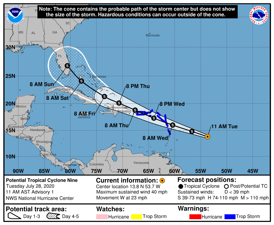
LOCATION…13.8N 53.7W
ABOUT 585 MI…940 KM ESE OF THE LEEWARD ISLANDS
MAXIMUM SUSTAINED WINDS…40 MPH…65 KM/H
PRESENT MOVEMENT…W OR 280 DEGREES AT 23 MPH…37 KM/H
MINIMUM CENTRAL PRESSURE…1007 MB…29.74 INCHES
WATCHES AND WARNINGS
A Tropical Storm Warning is in effect for…
* Puerto Rico, Vieques, Culebra
* U.S. Virgin Islands
* British Virgin Islands
* Antigua, Barbuda, Montserrat, St. Kitts, and Nevis
* Guadeloupe, Martinique, and St. Martin
* Saba and St. Eustatius
* St. Maartin
FORECAST DISCUSSION
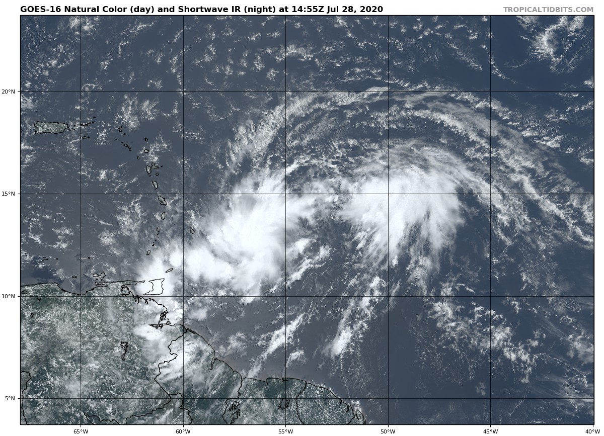
Shower and thunderstorm activity has increased overnight and this morning in association with a broad area of low pressure located several hundred miles east of the Lesser Antilles. Recent visible satellite imagery and ASCAT data show that the system’s circulation is quite elongated and lacks a well-defined center. Observations from NOAA buoy 41040 and ASCAT suggest that the system is already producing winds of 30-35 kt, and the system’s initial intensity has been set to 35 kt. Dry air located just to the north of the system has been hindering development over the past couple of days, but environmental conditions are expected to be more conducive for development over the next couple of days. Therefore, the system is likely to become a tropical storm before it reaches the Leeward Islands, and advisories are being initiated in order to issue Tropical Storm Warnings for a portion of the Leeward Islands, the U.S. and British Virgin Islands, and Puerto Rico. A U.S. Air Force Reserve reconnaissance aircraft is scheduled to investigate the system early this afternoon and should provide additional information on the intensity and structure of the low-pressure area.
It cannot be stressed enough that since the system is still in the formative stage, greater than average uncertainty exists regarding both the short-term and longer-term track and intensity forecasts. A subtropical ridge that extends westward from the central Atlantic is expected to be the dominant steering mechanism over the next several days, and the flow around this ridge should steer the low-pressure area generally west-northwestward. However, the details in the track forecast could change depending on exactly where within elongated circulation the center forms. Regardless of the exact track, the system is expected to bring locally heavy rainfall to much of the Lesser Antilles, and tropical-storm-force winds to portions of the Leeward Islands, the Virgin Islands, and Puerto Rico within the next 24-48 hours. After that time, a general west-northwestward heading should continue but as mentioned before, uncertainty exists as to how close the system tracks to Hispaniola, Cuba, the Bahamas, and Florida. The NHC track forecast is in best agreement with the HFIP corrected consensus model. It should be noted that a stronger cyclone is likely to favor a more northern track, while a weaker system is likely to remain more equatorward. Users should remember that the long-term average NHC track forecast errors at days 4 and 5 are 140 and 175 n mi, respectively.
Given the current structure of the system, only gradual strengthening is predicted during the next day or two, however, the system is expected to become a tropical storm when it is near the Leeward Islands on Wednesday. After 48 hours, possible land interaction with the Greater Antilles, and increasing south to southwesterly shear from an upper-level trough could temper further strengthening. The global models generally weaken the system due to these negative factors and the NHC forecast calls for little change in strength at the longer range.
KEY MESSAGES
1. Potential Tropical Cyclone Nine will produce heavy rains and potentially life-threatening flash flooding and mudslides across the northern Leeward Islands, the Virgin Islands, and Puerto Rico.
2. Tropical storm conditions are likely across portions of The Leeward Islands, the Virgin Islands, and Puerto Rico Wednesday through Thursday and Tropical Storm Warnings are in effect. Do not focus on the details of the track forecast, as rainfall and wind hazards will extend far from the center of the system.
3. The details of the long-range track and intensity forecasts are more uncertain than usual since the system does not have a well-defined center and could move over portions of the Greater Antilles later this week. However, this system could bring some rainfall and wind impacts to portions of Hispaniola, Cuba, the Bahamas, and Florida by the end of the week.
Category: ALL POSTS
About the Author (Author Profile)
Scott Martin is an operational meteorologist, professional graphic artist, musician, husband, and father. Not only is Scott a member of the National Weather Association, but he is also the Central Alabama Chapter of the NWA president. Scott is also the co-founder of Racecast Weather, which provides forecasts for many racing series across the USA. He also supplies forecasts for the BassMaster Elite Series events including the BassMaster Classic.Subscribe
If you enjoyed this article, subscribe to receive more just like it.


