Isaias Producing Life-Threatening Flash Flooding & Gusty Winds Over Puerto Rico
SUMMARY OF 1100 AM AST…1500 UTC…INFORMATION
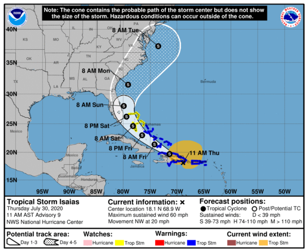
LOCATION…18.1N 68.9W
ABOUT 50 MI…75 KM SW OF PUNTA CANA DOMINICAN REPUBLIC
ABOUT 165 MI…265 KM SE OF PUERTO PLATA DOMINICAN REPUBLIC
MAXIMUM SUSTAINED WINDS…60 MPH…95 KM/H
PRESENT MOVEMENT…NW OR 310 DEGREES AT 20 MPH…31 KM/H
MINIMUM CENTRAL PRESSURE…1003 MB…29.62 INCHES
WATCHES AND WARNINGS
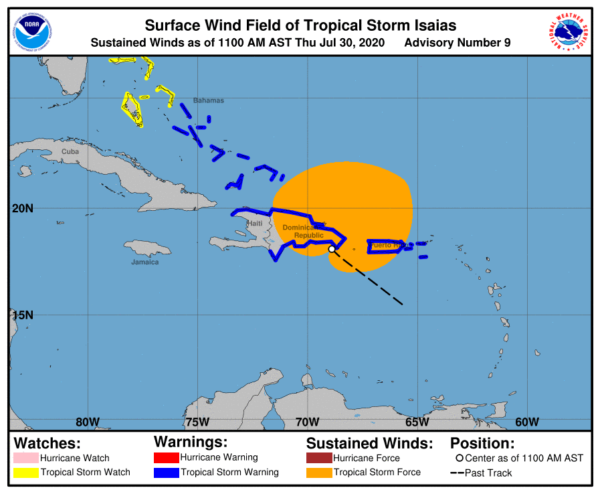
A Tropical Storm Warning is in effect for…
* Puerto Rico, Vieques, Culebra
* U.S. Virgin Islands
* Dominican Republic entire southern and northern coastlines
* North coast of Haiti from Le Mole St Nicholas eastward to the northern border with the Dominican Republic
* Turks and Caicos Islands
* Southeastern Bahamas including the Acklins, Crooked Island, Long Cay, the Inaguas, Mayaguana, and the Ragged Islands
* Central Bahamas, including Cat Island, the Exumas, Long Island, Rum Cay, and San Salvador
A Tropical Storm Watch is in effect for…
* Northwestern Bahamas including Andros Island, New Providence, Eleuthera, Abacos Islands, Berry Islands, Grand Bahamas Island, and Bimini
FORECAST DISCUSSION
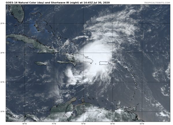
The satellite presentation of Isaias has improved over the past 24 hours with a concentrated area of deep convection occurring near and to the northeast of the low-level center. Radar imagery from Puerto Rico has shown a mid-level circulation that moved over the Mona passage and is now along the northern coast of Hispaniola. Surface observations and data from an Air Force Reserve reconnaissance aircraft, however, continue to place the center near the southeastern coast of Hispaniola. It is possible that a new center will re-form along the northern coast of Hispaniola as the system interacts with high terrain of that island later today or tonight. The initial intensity remains 50 kt and is based on the earlier Doppler radar data and observations along the southern coast of Puerto Rico.
Isaias is moving northwestward or 310/16 kt. A high-pressure ridge over the western Atlantic should steer Isaias on a west-northwestward to northwestward heading over the next couple of days, but the likelihood of a center re-formation during the next 12-18 hours means that some adjustments to the track and motion are possible. By late Friday, a mid-latitude trough moving into the east-central United States is expected to weaken the western portion of the ridge. This pattern should cause the cyclone to turn northwestward to north-northwestward on Saturday when it is near the northwestern Bahamas and South Florida. As the trough slides eastward over the United States, this should steer Isaias northward and northeastward early next week. Although the bulk of the track guidance agrees on this overall scenario, the confidence in the track forecast remains lower than usual due to the expected land interaction and possible center reformation in the short term. The new NHC track forecast is a blend of the HFIP corrected consensus and the TCVA multi-model consensus and is similar to the previous advisory.
The intensity forecast remains challenging. The structure of the storm is likely to be disrupted by its passage near or over Hispaniola today, and some weakening is likely. Once the system moves away from the Greater Antilles gradual strengthening is anticipated. The global models and the SHIPS guidance suggest that Isaias will encounter an area of moderate southwesterly shear over the weekend, and the NHC intensity forecast is again leveled off at that time. There are models that continue to suggest Isaias could become a hurricane when it is near the U.S., but given the continued uncertainty, the NHC intensity forecast remains near the intensity consensus.
KEY MESSAGES
1. Isaias will produce heavy rains and potentially life-threatening flash flooding and mudslides across Puerto Rico, the Dominican Republic, northern Haiti, the Turks and Caicos, and the Bahamas. Heavy rains associated with Isaias may begin to affect South Florida Saturday morning, potentially resulting in isolated flash and urban flooding.
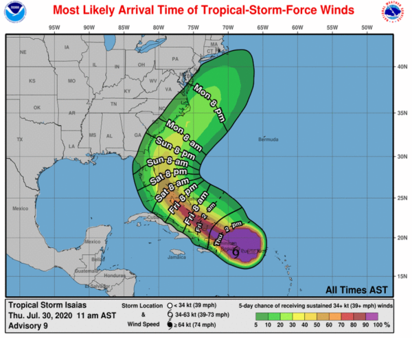
2. Tropical storm conditions will continue across portions of The Virgin Islands and Puerto Rico through early afternoon and will spread across portions of the Dominican Republic, Haiti, the Turks and Caicos, and the Bahamas later today through Friday, and Tropical Storm Warnings are in effect for these areas. Do not focus on the details of the track forecast, as rainfall and wind hazards will extend far from the center of the system.
3. There is a risk of impacts from winds, heavy rainfall, and storm surge along portions of the U.S. east coast beginning this weekend in Florida and spreading northward to the Carolinas and southern mid-Atlantic states early next week. Due to Isaias interacting with Hispaniola, the details of the track and intensity forecast remain uncertain and it is too soon to determine the magnitude and location of these potential impacts. Interests in these areas should monitor the progress of Isaias and updates to the forecast. Tropical storm or hurricane watches could be issued for portions of South Florida later today.
Category: ALL POSTS, Severe Weather, Tropical
About the Author (Author Profile)
Scott Martin is an operational meteorologist, professional graphic artist, musician, husband, and father. Not only is Scott a member of the National Weather Association, but he is also the Central Alabama Chapter of the NWA president. Scott is also the co-founder of Racecast Weather, which provides forecasts for many racing series across the USA. He also supplies forecasts for the BassMaster Elite Series events including the BassMaster Classic.Subscribe
If you enjoyed this article, subscribe to receive more just like it.


