Mainly Dry & Warm at Midday; More Showers & Storms Expected This Afternoon
TAKING A LOOK OUT THE WINDOW AT 11:10 AM
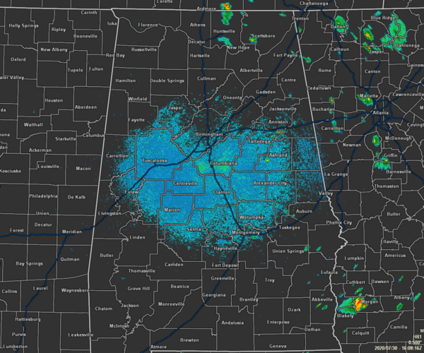
Skies are currently partly to mostly sunny across Central Alabama as we make our way to the midday hour, but we do have a few spotty showers over in the eastern part of the area over the southern tip of Calhoun County and down over the western part of Clay County. There are a couple more spotty showers down in Bullock and Russell counties in the southeastern parts of the area, but the rest of Central Alabama is dry.
Temperatures as of the 11:00 am Round-Up were in the upper 70s to the upper 80s. Montgomery was the warm spot at 87 degrees while Haleyville was the cool spot at 79 degrees. Birmingham was sitting at 84 degrees, tied with Pell City and Prattville.
WHAT’S IN STORE FOR THE REST OF YOUR THURSDAY
As we move into the afternoon hours, skies will be mostly cloudy and we’ll see scattered to numerous showers and thunderstorms develop with most of the activity occurring north of a line from Tuscaloosa to Clanton to Auburn. Showers and storms will be possible as well south of that line, but chances will be less likely. At this point, severe storms do not look likely, but one or two storms may become briefly strong with gusty winds and small hail. Afternoon highs will be in the upper 80s to the lower 90s.
As we lose the heating of the day, coverage in the shower and thunderstorm activity will diminish somewhat, but a few may linger through the evening and into the overnight hours especially over the extreme northern parts of Central Alabama. Otherwise, skies will be mostly cloudy and lows will be in the lower to mid-70s.
FRIDAY’S FORECAST
Skies will be mostly cloudy with scattered to numerous showers and thunderstorms possible for the southern half of Central Alabama and likely for the northern half. While it won’t rain all day, rain can be expected at any time, especially during the afternoon and early evening hours. It will be getting hot again as highs will top out in the upper 80s to the lower 90s.
ISAIAS PRODUCING HEAVY RAINS & GUSTY WINDS OVER PUERTO RICO & THE DOMINICAN REPUBLIC
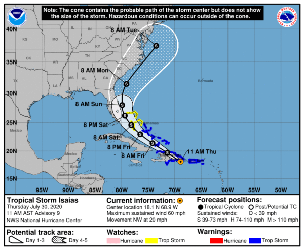
Tropical Storm Isaias was located about 50 miles southwest of Punta Cana, Dominican Republic as of 10:00 am this morning with maximum sustained winds at 60 MPH. The movement was to the northwest at 20 MPH and the minimum central pressure was at 1003 MB.
Isaias will produce heavy rains and potentially life-threatening flash flooding and mudslides across Puerto Rico, the Dominican Republic, northern Haiti, the Turks and Caicos, and the Bahamas. Heavy rains associated with Isaias may begin to affect South Florida Saturday morning, potentially resulting in isolated flash and urban flooding.
Tropical storm conditions will continue across portions of The Virgin Islands and Puerto Rico through early afternoon and will spread across portions of the Dominican Republic, Haiti, the Turks and Caicos, and the Bahamas later today through Friday, and Tropical Storm Warnings are in effect for these areas. Do not focus on the details of the track forecast, as rainfall and wind hazards will extend far from the center of the system.
There is a risk of impacts from winds, heavy rainfall, and storm surge along portions of the U.S. east coast beginning this weekend in Florida and spreading northward to the Carolinas and southern mid-Atlantic states early next week. Due to Isaias interacting with Hispaniola, the details of the track and intensity forecast remain uncertain and it is too soon to determine the magnitude and location of these potential impacts. Interests in these areas should monitor the progress of Isaias and updates to the forecast. Tropical storm or hurricane watches could be issued for portions of South Florida later today.
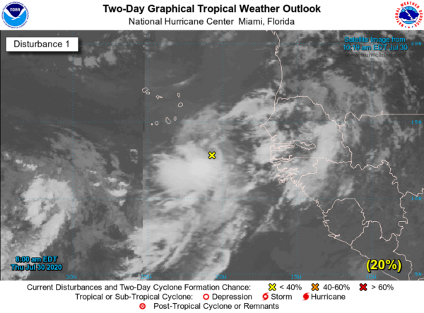
ANOTHER WAVE JUST OFF OF THE AFRICAN COAST
Showers and thunderstorms associated with a broad area of low pressure, located a few hundred miles south-southeast of the Cabo Verde Islands have become more concentrated this morning. Some development of this system is possible during the next day or two before environmental conditions become unfavorable. Chances of formation within the next five days is low at 20%.
Category: Alabama's Weather, ALL POSTS, Tropical
About the Author (Author Profile)
Scott Martin is an operational meteorologist, professional graphic artist, musician, husband, and father. Not only is Scott a member of the National Weather Association, but he is also the Central Alabama Chapter of the NWA president. Scott is also the co-founder of Racecast Weather, which provides forecasts for many racing series across the USA. He also supplies forecasts for the BassMaster Elite Series events including the BassMaster Classic.Subscribe
If you enjoyed this article, subscribe to receive more just like it.


