As of the 4:00 pm Update, Isaias Weakens to a Tropical Storm

SUMMARY OF 400 PM CDT…2100 UTC…INFORMATION
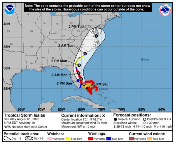
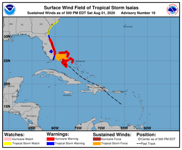
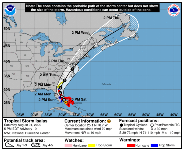
LOCATION…25.1N 78.7W
ABOUT 115 MI…185 KM SE OF FORT LAUDERDALE FLORIDA
ABOUT 95 MI…155 KM S OF FREEPORT GRAND BAHAMA ISLAND
MAXIMUM SUSTAINED WINDS…70 MPH…110 KM/H
PRESENT MOVEMENT…NW OR 310 DEGREES AT 10 MPH…17 KM/H
MINIMUM CENTRAL PRESSURE…993 MB…29.33 INCHES
WATCHES AND WARNINGS
A Hurricane Warning is in effect for…
* Boca Raton to the Volusia/Flagler County Line Florida
* Northwestern Bahamas
A Storm Surge Watch is in effect for…
* Jupiter Inlet to Ponte Vedra Beach Florida
A Tropical Storm Warning is in effect for…
* North of Ocean Reef to the south of Boca Raton Florida
* Lake Okeechobee
* Volusia/Flagler County Line to Ponte Vedra Beach Florida
A Tropical Storm Watch is in effect for…
* North of Ponte Vedra Beach Florida to South Santee River South Carolina
FORECAST DISCUSSION
The last data received from a previous Air Force Reserve reconnaissance aircraft, along with recent satellite and radar imagery, indicate that Isaias has weakened to a tropical storm due to a combination of shear, dry air, and interaction with Andros Island earlier today. The initial intensity of 60 kt is based on SFMR surface wind speeds of near 60 kt in the northeastern quadrant on the last flight. A new reconnaissance mission into the cyclone is currently ongoing and will provide new data concerning the Isaias’ intensity.
The initial motion estimate is 315/09 kt. After making a slight west-northwestward jog a few hours ago after convection significantly weakened, Isaias appears to have returned to its base northwestward course. The new NHC model guidance is tightly packed but has shifted slightly westward, with some of the more reliable models now showing landfall along the east-central Florida coast in about 24 hours. Earlier NOAA G-IV jet dropsonde data and 12Z upper-air data reveal that the surface to 700 MB ridge extending east-west across central and northern Florida remains intact whereas the 500-300 MB ridge has completely eroded. The result is that lower-level ridge will cause Isaias to slow its forward motion to northwestward at 6-8 kt during the next 36 hours. By 48 hours, the erosion of the ridge due to an approaching shortwave trough will allow the cyclone to move northward, followed by a gradual increase in forward speed toward the northeast on days 3-5. The new NHC track forecast was nudged slightly closer to the Florida east-central coast through 24 hours, with no significant changes made to the previous forecast after 36 hours.
A combination of Isaias moving over the warm Gulfstream waters during the convective maximum period and increasing frictional convergence due to land interaction with Florida should lead to an increase in deep convection near and over the center, as shown by simulated satellite imagery from the ECMWF model. As a result, Isaias is forecast to regain hurricane status tonight, as shown by the HWRF and HMON model fields. By 36 hours and beyond, the global models are in good agreement that an approaching mid- to upper-level trough will increase southwesterly vertical wind shear, which should result in gradual weakening until Isais becomes an extratropical cyclone in about 96 hours. The new NHC intensity forecast is closest to the HMON in 12 hours and closely follows the IVCN and HCCA consensus models after 36 hours.
KEY MESSAGES
1. Hurricane conditions and dangerous storm surge will continue in portions of the northwest Bahamas tonight.
2. Hurricane conditions are expected along portions of the Florida east coast on Sunday with tropical storm conditions expected to begin tonight. Preparations to protect life and property should be rushed to completion.
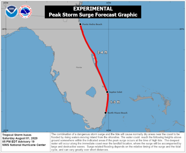
3. Dangerous storm surge is possible along the Florida east coast from Jupiter Inlet to Ponte Vedra Beach where water rises of 2 to 4 feet above ground level are possible along the immediate coastline and adjacent waterways. Residents there should follow the advice given by local emergency officials.
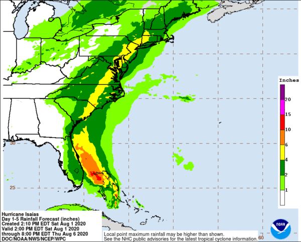
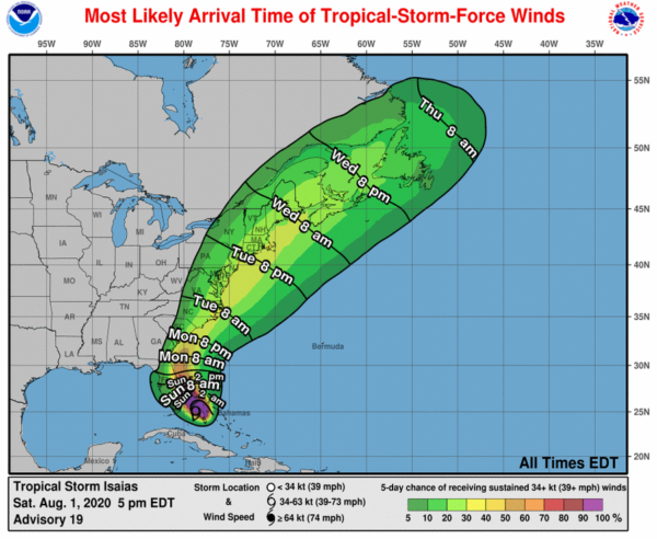
4. Isaias will produce heavy rains and potentially life-threatening flash flooding in the Bahamas, and flash and urban flooding, especially in low-lying and poorly drained areas, along the East Coast of the United States. Minor river flooding and isolated moderate river flooding is possible across portions of the Carolinas and Virginia early next week.
5. Tropical storm watches and warnings are in effect for portions of the United States East Coast from northeast Florida to South Carolina. Additional watches and warnings will likely be issued tonight and Sunday as Isaias is expected to move northward near or over the southeast and mid-Atlantic coasts early next week.
Category: ALL POSTS, Severe Weather, Tropical
About the Author (Author Profile)
Scott Martin is an operational meteorologist, professional graphic artist, musician, husband, and father. Not only is Scott a member of the National Weather Association, but he is also the Central Alabama Chapter of the NWA president. Scott is also the co-founder of Racecast Weather, which provides forecasts for many racing series across the USA. He also supplies forecasts for the BassMaster Elite Series events including the BassMaster Classic.Subscribe
If you enjoyed this article, subscribe to receive more just like it.


