Isaias Potentially Making Landfall As a Hurricane Near the NC/SC Border Later This Evening
SUMMARY OF 1100 AM EDT…1500 UTC…INFORMATION
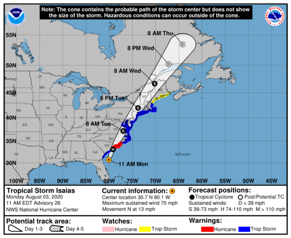
LOCATION…30.7N 80.1W
ABOUT 90 MI…145 KM ESE OF BRUNSWICK GEORGIA
ABOUT 220 MI…350 KM SSW OF MYRTLE BEACH SOUTH CAROLINA
MAXIMUM SUSTAINED WINDS…70 MPH…110 KM/H
PRESENT MOVEMENT…N OR 360 DEGREES AT 13 MPH…20 KM/H
MINIMUM CENTRAL PRESSURE…998 MB…29.47 INCHES
SUMMARY OF WATCHES AND WARNINGS IN EFFECT
A Storm Surge Warning is in effect for…
* Edisto Beach South Carolina to Cape Fear North Carolina
* Pamlico and Albemarle Sounds, including the Neuse and Pamlico Rivers
* Oregon Inlet North Carolina to the North Carolina/Virginia border
A Storm Surge Watch is in effect for…
* Cape Fear to Oregon Inlet North Carolina
A Hurricane Warning is in effect for…
* South Santee River South Carolina to Surf City North Carolina
A Tropical Storm Warning is in effect for…
* Altamaha Sound Georgia to South Santee River South Carolina
* North of Surf City North Carolina to the Mouth of the Merrimack River
* Pamlico and Albemarle Sounds
* Chesapeake Bay
* Tidal Potomac River
* Delaware Bay
* Long Island and Long Island Sound
* Martha’s Vineyard, Nantucket, and Block Island
A Tropical Storm Watch is in effect for…
* Mouth of the Merrimack River to Eastport Maine
DISCUSSION AND OUTLOOK
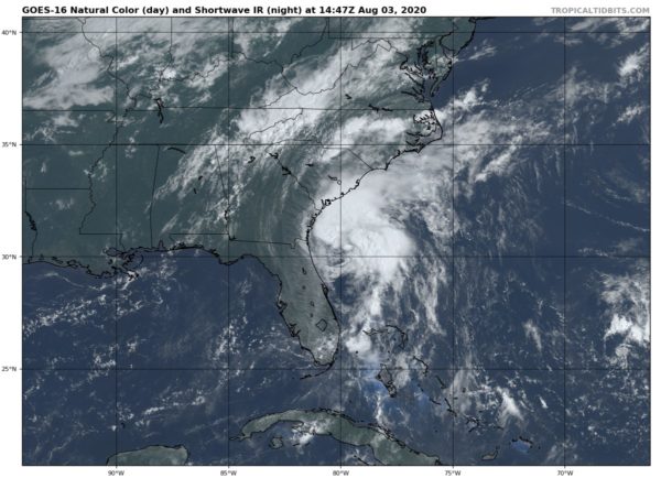
At 1100 AM EDT (1500 UTC), the center of Tropical Storm Isaias was located by an Air Force Reserve reconnaissance aircraft and NOAA Doppler weather radars near latitude 30.7 North, longitude 80.1 West. Isaias is moving toward the north near 13 mph (20 km/h), and this general motion is expected to continue today. A turn toward the north-northeast along with an increase in forward speed is expected by this late afternoon or early evening, followed by a faster northeastward motion tonight and Tuesday. On the forecast track, the center of Isaias will pass well east of the Georgia coast through this afternoon. The center of Isaias will then approach the coasts of northeastern South Carolina and southern North Carolina within the hurricane warning area this evening. The center will then move inland over eastern North Carolina tonight, and move along the coast of the mid-Atlantic states on Tuesday and into the northeastern United States Tuesday night.
Data from the reconnaissance aircraft and NOAA Doppler weather radars indicate that maximum sustained winds remain near 70 mph (110 km/h) with higher gusts. Some strengthening is forecast this afternoon, and Isaias is expected to regain hurricane strength just before it reaches the coast of northeastern South Carolina or southern North Carolina tonight. Only slow weakening is anticipated after Isaias makes landfall in the Carolinas and moves across the U.S. mid-Atlantic region tonight and Tuesday.
Tropical-storm-force winds extend outward up to 125 miles (205 km) from the center.
The estimated minimum central pressure based on reports from the aircraft is 998 MB (29.47 inches).
KEY MESSAGES
1. There is the danger of life-threatening storm surge inundation along portions of the immediate coastline and adjacent waterways of northeastern South Carolina and the North Carolina coast in the Storm Surge Warning area. Residents in these areas should follow the advice given by local emergency officials.
2. Isaias is forecast to regain hurricane strength before it reaches the coast of northeastern South Carolina and southern North Carolina, and hurricane conditions are expected in the Hurricane Warning area by this evening. Preparations should be rushed to completion.
3. Isaias is expected to bring widespread sustained tropical-storm-force winds and wind gusts to hurricane force to the mid-Atlantic coast Tuesday, which could cause tree damage and power outages. Tropical storm conditions are expected to reach southern New England on late Tuesday and are possible along the northern New England coast Tuesday night and early Wednesday.
4. Heavy rainfall will result in flash and urban flooding, some of which may be significant in the eastern Carolinas and the mid-Atlantic, through Tuesday night near the path of Isaias up the East Coast of the United States. Widespread minor to moderate river flooding is possible across portions of the Carolinas and the Mid-Atlantic.
All information from the National Hurricane Center’s 10:00 am Update.
Category: ALL POSTS, Severe Weather, Tropical
About the Author (Author Profile)
Scott Martin is an operational meteorologist, professional graphic artist, musician, husband, and father. Not only is Scott a member of the National Weather Association, but he is also the Central Alabama Chapter of the NWA president. Scott is also the co-founder of Racecast Weather, which provides forecasts for many racing series across the USA. He also supplies forecasts for the BassMaster Elite Series events including the BassMaster Classic.Subscribe
If you enjoyed this article, subscribe to receive more just like it.


