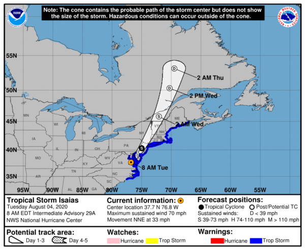
Center of Isaias Moving Across Southeastern Virginia
SUMMARY OF 800 AM EDT…1200 UTC…INFORMATION
LOCATION…37.7N 76.8W
ABOUT 15 MI…20 KM SSE OF TAPPAHANNOCK VIRGINIA
MAXIMUM SUSTAINED WINDS…70 MPH…110 KM/H
PRESENT MOVEMENT…NNE OR 25 DEGREES AT 33 MPH…54 KM/H
MINIMUM CENTRAL PRESSURE…993 MB…29.33 INCHES
SUMMARY OF WATCHES AND WARNINGS IN EFFECT
A Storm Surge Warning is in effect for…
* Pamlico and Albemarle Sounds
* Ocracoke Inlet North Carolina to the North Carolina/Virginia border
A Tropical Storm Warning is in effect for…
* North of Surf City North Carolina to Eastport Maine
* Pamlico and Albemarle Sounds
* Chesapeake Bay
* Tidal Potomac River
* Delaware Bay
* Long Island and Long Island Sound
* Martha’s Vineyard, Nantucket, and Block Island
DISCUSSION AND OUTLOOK
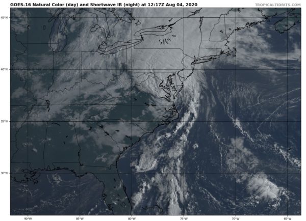
At 800 AM EDT (1200 UTC), the center of Tropical Storm Isaias was located over southeastern Virginia near latitude 37.7 North, longitude 76.8 West. Isaias is moving toward the north-northeast near 33 mph (54 km/h), and this general motion accompanied by some additional increase in forward speed is expected through today. On the forecast track, the center of Isaias will continue to move near or along the coast of the mid-Atlantic states today, and move across the northeastern United States into southern Canada tonight.
Maximum sustained winds are near 70 mph (110 km/h) with higher gusts. Only gradual weakening is anticipated while Isaias moves north-northeastward near the mid-Atlantic coast today. A faster rate of weakening is expected to begin tonight, and the system is forecast to become post-tropical tonight or early Wednesday.
Tropical-storm-force winds extend outward up to 140 miles (220 km) from the center. Sustained winds of 63 mph (101 km/h) and a gust to 77 mph (124 km/h) were recently reported at Third Island, Virginia, at the mouth of the Chesapeake Bay.
The estimated minimum central pressure based on surface observations is 993 MB (29.33 inches).
HAZARDS AFFECTING LAND
STORM SURGE: The combination of a dangerous storm surge and the tide will cause normally dry areas near the coast to be flooded by rising waters moving inland from the shoreline. The deepest water will occur along the immediate coast in areas of onshore winds, where the surge will be accompanied by large waves. Surge-related flooding depends on the relative timing of the surge and the tidal cycle and can vary greatly over short distances.
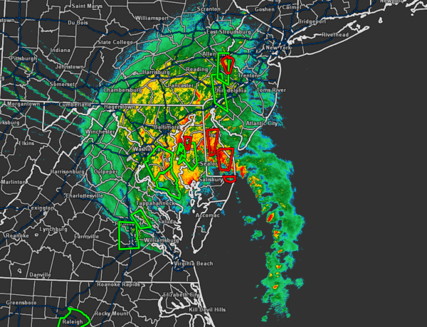
WIND: Widespread tropical-storm conditions are expected in the tropical storm warning area from North Carolina through the mid-Atlantic states, including portions of the Chesapeake Bay region today, with wind gusts to hurricane force possible. These winds could cause tree damage and power outages.
Tropical storm conditions are expected to reach southern New England this afternoon and northern New England tonight. Gale-force winds are expected to spread into southeastern Quebec
tonight and Wednesday.
RAINFALL: Heavy rainfall along the East Coast, near the path of Isaias, will result in flash and urban flooding, some of which may be significant in North Carolina through the Mid-Atlantic and Northeast through tonight. Potentially life-threatening urban flooding is possible in D.C., Baltimore, and elsewhere along and just west of the I-95 corridor today. Widespread minor to moderate river flooding is likely across portions of the Carolinas and the Mid-Atlantic. Quick-responding rivers in the Northeast will also be susceptible to minor river flooding.
TORNADOES: Tornadoes are most likely through midday from southeast Virginia to New Jersey. Tornadoes will remain possible this afternoon and evening from southeast New York across New England.
SURF: Swells generated by Isaias will spread northward along the Mid-Atlantic and Northeast coasts of the United States today. These swells are likely to cause life-threatening surf and rip current conditions. Please consult products from your local weather office.
All information from the National Hurricane Center’s 7:00 am CDT Update.
Category: ALL POSTS, Severe Weather, Tropical
About the Author (Author Profile)
Scott Martin is an operational meteorologist, professional graphic artist, musician, husband, and father. Not only is Scott a member of the National Weather Association, but he is also the Central Alabama Chapter of the NWA president. Scott is also the co-founder of Racecast Weather, which provides forecasts for many racing series across the USA. He also supplies forecasts for the BassMaster Elite Series events including the BassMaster Classic.Subscribe
If you enjoyed this article, subscribe to receive more just like it.


