Quiet Weather Pattern For Alabama
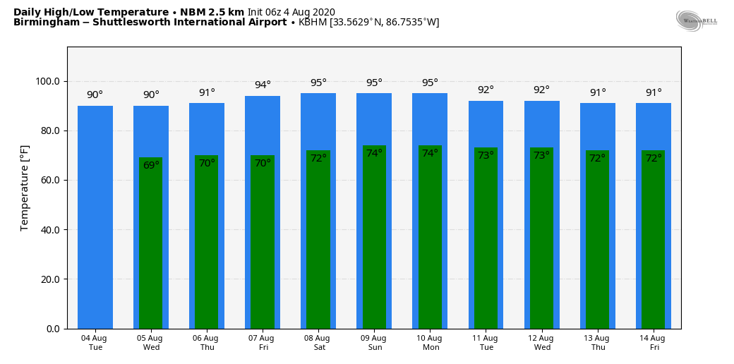
ONLY ISOLATED SHOWERS: Drier air continue to slip into Alabama this morning, and that will limit rain chances today. Still, a few isolated showers or storms will be possible thanks to an unusually deep upper trough over the eastern third of the nation, but odds of any one spot getting wet today are only 15/20 percent. Otherwise, the day will be partly to mostly sunny with a high between 87 and 90 degrees.
REST OF THE WEEK: Not much change tomorrow through Friday. Mostly sunny days, fair nights, and only isolated showers. Highs will be in the 88-92 degree range, and lows will be in the upper 60s for most communities. The chance of any one location seeing a shower is only 10-15 percent each day.
THE ALABAMA WEEKEND: The quiet weather pattern continues. Look for a good supply of sunshine Saturday and Sunday with highs in the low 90s; chance of shower for any one spot Saturday is only about 5 percent, and 15-20 percent Sunday.
NEXT WEEK: Moisture levels will slowly rise, and we will see the return of random, scattered, mostly afternoon and evening showers and thunderstorms on most days with highs remaining in the low 90s, right at seasonal averages for mid-August. See the Weather Xtreme video for maps, graphics, and more details.
ISAIAS IS INLAND: Isaias made landfall as a category one hurricane last night on the southern North Carolina coast just below Wilmington. It will race to the northeast today bringing wind and rain along the path.
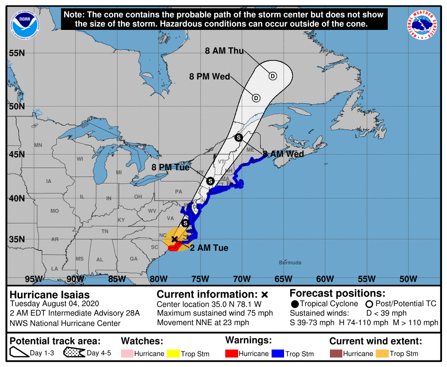
Isaias is expected to bring widespread sustained tropical storm force winds and wind gusts to hurricane force to the mid-Atlantic coast, including portions of the Chesapeake Bay region, through this afternoon, which could cause tree damage and power outages. Tropical storm conditions are expected to spread across New England tonight.
Heavy rainfall along the East Coast, near the path of Isaias, will result in flash flooding, some of which may be significant in North Carolina through the Mid-Atlantic and Northeast through tonight. Potentially life-threatening urban flooding is possible in D.C., Baltimore, and elsewhere along and just west of the I-95 corridor today. Widespread minor to moderate river flooding is likely across portions of the Carolinas and the Mid-Atlantic. Quick-responding rivers in Northeast will also be susceptible to minor river flooding.
Tornadoes have already occurred over portions of northeastern North Carolina and southeastern Virginia overnight. The threat of tornadoes will spread northward along the mid-Atlantic coast today and then across New England by tonight.
INVEST 94L: The disturbance south of Bermuda seems to be dissipating due to very dry air surrounding the system, and the rest of the Atlantic basin is quiet this morning.
ON THIS DATE IN 2009: The strongest tornado to hit Quebec since the same date in 1994 ripped through Mont-Laurier. The F2 tornado tore through the small western Quebec town severely damaging about 40 homes. Two men were taken to the hospital with minor injuries.
BEACH FORECAST: Click here to see the AlabamaWx Beach Forecast Center page.
WEATHER BRAINS: Don’t forget you can listen to our weekly 90 minute show anytime on your favorite podcast app. This is the show all about weather featuring many familiar voices, including our meteorologists here at ABC 33/40.
CONNECT: You can find me on all of the major social networks…
Facebook
Twitter
Instagram
Pinterest
Snapchat: spannwx
Look for the next Weather Xtreme video here by 4:00 this afternoon… enjoy the day!
Category: Alabama's Weather, ALL POSTS, Weather Xtreme Videos
About the Author (Author Profile)
James Spann is one of the most recognized and trusted television meteorologists in the industry. He holds the AMS CCM designation and television seals from the AMS and NWA. He is a past winner of the Broadcast Meteorologist of the Year from both professional organizations.Subscribe
If you enjoyed this article, subscribe to receive more just like it.


