

Weather Xtreme: Increasing Heat This Weekend, Rain Chances Go Up for the Workweek
MUCH OF CENTRAL ALABAMA STAYS DRY FOR THE WEEKEND
We’ll start off your Saturday with a front that has stalled out near the US-80 and I-85 corridors in the southern parts of the area, and it doesn’t look like it will move much at all. Skies will be mostly clear for the northern half of Central Alabama and will be partly cloudy in the south. More moisture will be available in the southern half of the area and that is where the small chance of isolated to scattered afternoon showers and thunderstorms will be. Afternoon highs will be in the mid to upper 90s.
That stalled front will be lifting to the northeast as a warm front and out of the area on Sunday. That will allow for moisture levels to start to creep back up across the area not only for Sunday but for the workweek ahead. Skies will be mostly sunny to partly cloudy with isolated afternoon rain chances looking rather low. Highs will once again reach the mid to upper 90s.
INCREASING MOISTURE = INCREASING RAIN CHANCES
The forecast for the work week looks to be one of repeat as there will be a good chance of scattered showers and thunderstorms mainly during the afternoon and evening hours across Central Alabama. Monday will be the drier day of the week as there will only be a chance of isolated to scattered afternoon showers and storms. Highs will be in the mid to upper 90s.
It will remain hot on Tuesday, but afternoon and evening shower and thunderstorm chances will be elevated as more moisture will be available. Highs will be in the lower to mid-90s.
Much of the same story on Wednesday as those chances of scattered to numerous mainly afternoon and evening showers and storms remain elevated. Highs will be in the lower to mid-90s.
Same story, different day for your Thursday… A good chance of afternoon and evening scattered showers and storms. Highs will be in the lower to mid-90s.
And to end off the workweek, not many changes expected for your Friday. Scattered mainly afternoon and evening showers and storms. Highs in the upper 80s to the lower 90s.
WHAT’S UP WITH THE TROPICS
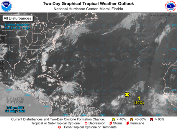
As of the 7:00 pm update on Friday night, we have a tropical wave located several hundred miles west-southwest of the Cabo Verde Islands is currently accompanied by a few showers and thunderstorms. Slow development of this system is possible during the next couple of days while it moves slowly westward. After that time, environmental conditions are expected to become less conducive for development. The National Hurricane Center is only giving it a 10% chance for development over the next five days. The rest of the Atlantic Basin remains surprisingly quiet.
BIRMINGHAM’S CLIMATE NORMALS FOR SATURDAY
Sunrise – 6:05 am CDT
Sunset – 7:40 pm CDT
Normal High: 91 degrees
Record High: 104 degrees (1935)
Normal Low: 71 degrees
Record Low: 60 degrees (1990)
Just one year ago, the year that was known for the unbelievable heat during the summer and into the start of fall, the high in Birmingham only reached 88 degrees due to cloud cover. That high was three degrees lower than the normal high for August 8th.
ON THIS DATE IN WEATHER HISTORY
1882 – An August snowstorm was reported by a ship on Lake Michigan. A thick cloud reportedly burst on the decks covering them with snow and slush six inches deep. Snow showers were observed at shore points that day.
1989 – A total of ninety-nine cities in the central and eastern U.S. reported record low temperatures for the date, including Alpena MI with a reading of 40 degrees. Mount Mitchell NC was the cold spot in the nation with a morning low of 35 degrees. Early evening thunderstorms around Las Vegas NV produced wind gusts to 116 mph. The high winds damaged or destroyed about eighty- two aircraft at Henderson Sky Harbor Airport and McCarran International Airport, causing fourteen million dollars damage.
BEACH FORECAST CENTER
Get the latest weather and rip current forecasts for the beaches from Dauphin Island, AL, to Panama City Beach, FL, on our Beach Forecast Center page. There, you can select the forecast of the region that you are interested in.
ADVERTISE ON THE BLOG!
We had another fantastic year in 2019 with just over 17 million page views! That brings our total for the last 2 years close to 37 million page views! Don’t miss out! We can customize a creative, flexible, and affordable package that will suit your organization’s needs. Contact Bill Murray at (205) 687-0782.
E-FORECAST
Get the Alabama Wx Weather Blog’s Seven-Day Forecast delivered directly to your inbox by email twice daily. It is the most detailed weather forecast available in Central Alabama. Subscribe here… It’s free!
CONNECT WITH THE BLOG ON SOCIAL MEDIA
You can find the AlabamaWx Weather Blog on the major social media networks:
Facebook
Twitter
Instagram
WEATHERBRAINS
There are several ways to watch or listen to the podcast that is all about the weather. Watch live starting at 8:00 pm CT on Monday nights at live.bigbrainsmedia.com, James Spann’s Youtube Channel, or on one of ABC 3340’s digital weather channels (17.2, 40.2, 68.3). Listen to the recorded audio podcast at WeatherBrains.com or on your favorite podcast platform (Apple Podcasts, Stitcher, Spotify, etc.), or watch the recorded video on James Spann’s Youtube channel.
Category: Alabama's Weather, ALL POSTS, Tropical, Weather Xtreme Videos
About the Author (Author Profile)
Scott Martin is an operational meteorologist, professional graphic artist, musician, husband, and father. Not only is Scott a member of the National Weather Association, but he is also the Central Alabama Chapter of the NWA president. Scott is also the co-founder of Racecast Weather, which provides forecasts for many racing series across the USA. He also supplies forecasts for the BassMaster Elite Series events including the BassMaster Classic.Subscribe
If you enjoyed this article, subscribe to receive more just like it.


