Sunday Weather Xtreme: Rain Chances Go Up, Heat Goes Down This Week
Did you catch the conjunction of the Moon and Mars last evening in the eastern sky? It won’t be quite as impressive tonight as the two will be further apart but catch it if you can.
BUT DO CATCH SOME PERSEIDS: Monday, Tuesday, and Wednesday evenings before moonrise will be good times to catch the annual Perseids meteor shower. There won’t be as many meteors as during the peak early morning hours, but viewing before moonrise will avoid the light of the moon. I also understand that you are more likely to get those impressive earth grazer meteors in the evening hours. Avoiding city lights will help of course. And if the moon is already up during your viewing hours, find a moon shadow. Some object like a tree line, or ridge, or barn that would block the light of the moon. Maybe Cat Stevens was singing about this when he sang “Moonshadow”.
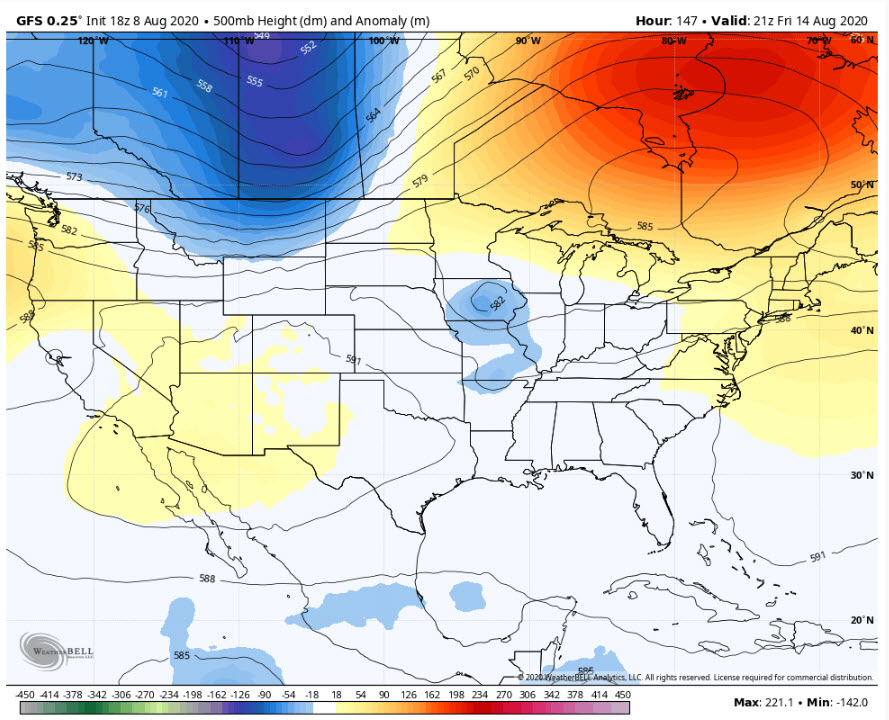
ON THE WEATHER MAPS: It is a fairly quiet pattern across the United States on this Sunday morning. There is a ridge of high pressure in the East, with a big trough over western Canada, extending down into the Plains states. There is a big ridge off the West Coast. Severe weather developed on Saturday in the area of lowered pressure over the Plains and more Is likely today across parts of the Dakotas, Minnesota, and Wisconsin. The heat is on across parts of Arizona and the Plains States. Temperatures will be in the 109-113 range around Phoenix today, where excessive heat warnings are in effect.
FOR YOUR SUNDAY: Here in Alabama, hot and humid conditions will prevail today, with highs in the upper 90s and heat index values hovering near or just above 100F. Isolated to scattered showers and thunderstorms will develop this afternoon. If you’re lucky enough to get one of those cooling storms, watch out for lightning and gusty winds.
THE WEEK AHEAD: The atmosphere will be moistening up as we go through the next few days, and that means more in the way of clouds and showers each day. It also means that the heat will back off just a tad, with highs by midweek back closer to 90F than 95F. Lows will be in the lower 70s.
WEEKEND: Those rain chances will remain elevated into the weekend. Most folks should pick up 1-3 inches of rain this week.
TROPICS: The Tropical Atlantic continues to be quiet…for now. A tropical wave midway between Africa and the islands of the Caribbean is disorganized and has a small chance of developing. Elsewhere, we don’t see anything major happening until the last week of August, when an upward tick f the Madden Julian Oscillation will enhance development. It will be a busy run into September. That lines up with climatology, which designates August 20th as the date when activity usually ramps up anyway.
SEASONAL FORECASTS UPDATED: The folks at Colorado State updated their seasonal forecast this week, now calling for 24 named storms and 12 hurricanes, of which 5 will be major hurricanes (category three or higher). The long term averages are 12 named storms, with between 6 and 7 hurricanes and just under 3 major hurricanes.
GULF COAST WEATHER: Fairly typical week of summertime weather along the beautiful beaches of Alabama and Northwest Florida. Expect 6-8 hours of intense sunshine each day, with warm and humid conditions. Highs will be in the lower 90ss to start the week, trending back to near 90F by midweek as rain chances creep upward a bit. Surf is running around 1 foot outside thunderstorms, and the rip current risk is low. Water temperatures are running in the middle 80s.
DANCING WITH THE STATS: It has reached 100F or hotter on three August 9ths in history in Birmingham, most recently in the hot summer of 2007. Before that, it was 1980, as we were watching Hurricane Allen in the Gulf. See today’s weather history entry. The 2007 occurrence is the hottest ever for this date at 103F. It has gotten as cool as 54F on August 9th here, back in 1976, as we were watching Hurricane Belle go up the East Coast. The record rainfall for the date is 2.99 inches, set in 1970. No tropical system then, although we had watched famous Hurricane Celia lunge into Texas earlier that week.
SIDEWALK: Our beloved Sidewalk Film Festival is a drive-in affair this year! Use ALWX15 and it’s 15% off for friends and family of the AlabamaWX blog! Go to SSidewalkFest.com to check out the lineup and get your tickets! Load up the car and go!
ADVERTISE WITH US: Deliver your message to a highly engaged audience by advertising on the AlabamaWX.com website. The site enjoyed 17.2 MILLION pageviews in the past 12 months. Don’t miss out! We can customize a creative, flexible and affordable package that will suit your organization’s needs. Contact me, Bill Murray, at (205) 687-0782, and let’s talk.
WEATHERBRAINS: Good show coming up this week talking with mets from the Miami Valley of Ohio Tornado Outbreak that occurred on Memorial Day in 2019. It was part of a two-week sequence of tornado outbreaks that plagued the country. Check out the show at www.WeatherBrains.com. You can also subscribe on iTunes. You can watch the show live at http://live.bigbrainsmedia.com/ You will be able to see the show on the James Spann 24×7 weather channel on cable or directly over the air on the dot 2 feed.
ON THIS DATE IN 1980: Hurricane Allen made landfall on the Texas coast just north of Brownsville TX. The center of Allen did not cross any land on its long trek across the Atlantic until it landed on the Texas coast, weaving and dodging islands like a football runner. Just off the Texas coast, Allen hesitated long enough to weaken to 945 mb (27.91 inches), and then moved inland north of Brownsville bringing highest tides and winds over the least populated section of the Texas coast. Earlier on the 9th, Air Force Reconnaissance measured a very low central pressure of 909 mb as Allen reached Category 5 status for the fifth time in its lifetime. Only two people died in Texas as a result of Allen. The strongest measured winds were gusts to 129 mph at Port Mansfield, TX. A storm surge up to 12 feet along Padre Island caused numerous barrier island cuts and washouts. Follow my weather history tweets on Twitter. I am @wxhistorian at Twitter.com.
Category: Alabama's Weather, ALL POSTS
About the Author (Author Profile)
Bill Murray is the President of The Weather Factory. He is the site's official weather historian and a weekend forecaster. He also anchors the site's severe weather coverage. Bill Murray is the proud holder of National Weather Association Digital Seal #0001 @wxhistorianSubscribe
If you enjoyed this article, subscribe to receive more just like it.


