Disorganized Laura Continues to Move Near Eastern Puerto Rico
SUMMARY OF 800 AM AST…1200 UTC…INFORMATION
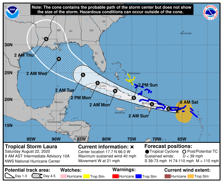
LOCATION…17.7N 66.0W
ABOUT 50 MI…80 KM S OF SAN JUAN PUERTO RICO
MAXIMUM SUSTAINED WINDS…40 MPH…65 KM/H
PRESENT MOVEMENT…W OR 280 DEGREES AT 21 MPH…33 KM/H
MINIMUM CENTRAL PRESSURE…1006 MB…29.71 INCHES
WATCHES AND WARNINGS
A Tropical Storm Warning is in effect for…
* Puerto Rico, Vieques and Culebra
* U.S. Virgin Islands
* British Virgin Islands
* St. Maarten
* St. Martin and St. Barthelemy
* The northern coast of the Dominican Republic from Cabo Engano to the border with Haiti
* The southern coast of the Dominican Republic from Cabo Engano to Punta Palenque
* The northern coast of Haiti from Le Mole St. Nicholas to the border with the Dominican Republic
* The southeastern Bahamas and the Turks and Caicos Islands
A Tropical Storm Watch is in effect for…
* The central Bahamas
DISCUSSION AND OUTLOOK
At 800 AM AST (1200 UTC), the center of Tropical Storm Laura was located near latitude 17.7 North, longitude 66.0 West. Laura is moving toward the west near 21 mph (33 km/h), and a generally west-northwestward motion is expected over the next few days. On the forecast track, the center of Laura will move near Puerto Rico this morning, near or over Hispaniola this afternoon and tonight, and near or over eastern Cuba Sunday and Sunday night.
Maximum sustained winds are near 40 mph (65 km/h) with higher gusts. Slow strengthening is expected during the next few days.
Tropical-storm-force winds extend outward up to 205 miles (335 km) mainly to the north of the center.
The estimated minimum central pressure based on surface observations is 1006 MB (29.71 inches).
HAZARDS AFFECTING LAND
RAINFALL: Laura is expected to produce 3 to 6 inches of rain over Puerto Rico and the Virgin Islands, the Dominican Republic, the southern Haitian Peninsula and eastern Cuba through Sunday. Maximum amounts up to 8 inches are possible along eastern portions and the southern slopes of Puerto Rico, as well as over Haiti, the Dominican Republic and eastern Cuba. This heavy rainfall could lead to flash and urban flooding, as well as an increased potential for mudslides with minor river flooding in Puerto Rico.
1 to 3 inches of rain with isolated maximum totals of 5 inches are expected over the northern Leeward Islands, the Turks and Caicos, and the southeast Bahamas.
WIND: Tropical storm conditions are expected within portions of the warning area this morning through Sunday. Tropical storm conditions are possible within portions of the watch area Sunday night.
SURF: Swells generated by Laura are affecting portions of the northern Leeward Islands. These swells are expected to spread across the northern coasts of Puerto Rico, Hispaniola and Cuba, and much of the Bahamas during the next few days. Please consult products from your local weather office.
Category: ALL POSTS, Severe Weather, Tropical
About the Author (Author Profile)
Scott Martin is an operational meteorologist, professional graphic artist, musician, husband, and father. Not only is Scott a member of the National Weather Association, but he is also the Central Alabama Chapter of the NWA president. Scott is also the co-founder of Racecast Weather, which provides forecasts for many racing series across the USA. He also supplies forecasts for the BassMaster Elite Series events including the BassMaster Classic.Subscribe
If you enjoyed this article, subscribe to receive more just like it.


