Saturday’s Weather Xtreme: Scattered Storms This Weekend, Model Madness Continues With Laura & Marco
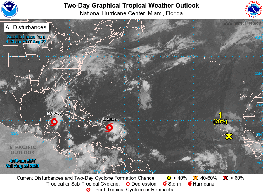
STARTING WITH THE TROPICS (4:00 AM SATURDAY UPDATE)
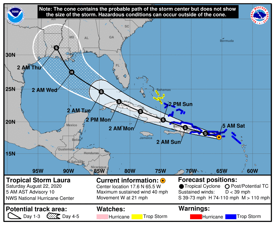
The center of Tropical Storm Laura was located around 70 miles southeast of San Juan, Puerto Rico. Laura is moving toward the west near 21 mph (33 km/h) and a generally west-northwestward motion is expected over the next few days. On the forecast track, the center of Laura will move near or over portions of the Virgin Islands and Puerto Rico this morning, near or over Hispaniola this afternoon and tonight, and near or over eastern Cuba Sunday and Sunday night.
Maximum sustained winds are near 40 mph (65 km/h) with higher gusts. Slow strengthening is expected during the next few days.
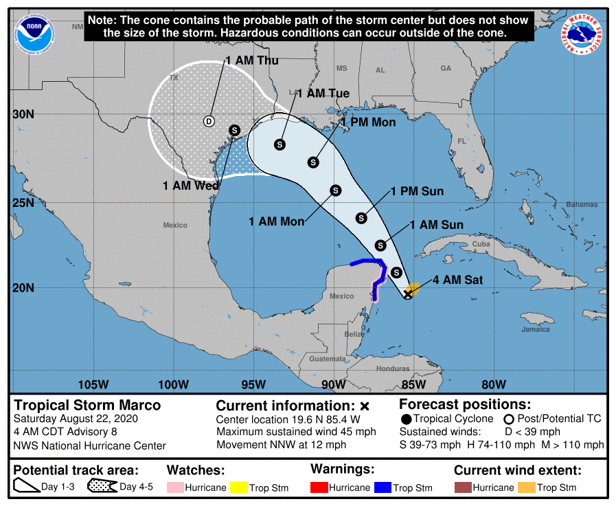
The center of Tropical Storm Marco was located around 115 miles east-southeast of Cozumel, Mexico. Marco is moving toward the north-northwest near 12 mph (19 km/h). A northwestward motion is expected on Sunday, followed by a turn toward the northwest and west-northwest early next week. On the forecast track, the center of Marco will approach the east coast of the Yucatan Peninsula of Mexico today. The center will approach the northeastern part of the Yucatan Peninsula by early evening and move over the central Gulf of Mexico toward the northwestern Gulf on Sunday and Monday followed by a track toward the northwestern Gulf coast Tuesday.
Maximum sustained winds are near 45 mph (75 km/h) with higher gusts. Additional strengthening is forecast during the next couple of days as the system approaches the Yucatan peninsula and Marco could be near hurricane strength when it moves over the central Gulf of Mexico Sunday night and early Monday.
Tropical Wave Disorganized showers and thunderstorms located between the west coast of Africa and the Cabo Verde Islands are associated with a broad area of low pressure and a tropical wave. This disturbance is expected to move westward across the Cabo Verde Islands on Saturday and it will likely produce gusty winds and locally heavy rainfall there. Some slow development of this wave could occur during the next couple of days while it moves across the eastern tropical Atlantic before environmental conditions become less favorable for development. It has a very low chance of developing into a tropical cyclone over the next five days, around 20%.
THE CENTRAL ALABAMA WEEKEND
Skies will be occasionally cloudy at times throughout the weekend with a decent chance of scattered to numerous showers and thunderstorms on both days. Most will occur during the afternoon and evening hours, but with this soupy atmosphere, a few morning and/or late-night showers and storms will be possible. Highs will be in the mid to upper 80s on both days.
TROPICAL SYSTEMS MAKING THE FORECAST A LITTLE TRICKY
The forecast for the work week all depends on where the two tropical systems end up going, but as of this morning’s 4:00 am update, we’ll see a minimal effect off of both storms. Monday will feature mostly cloudy skies with a decent chance of scattered showers and storms throughout much of the day as we could see some tropical moisture being pulled up into Central Alabama especially on Monday evening. Much of the same story for Tuesday as tropical moisture will be available and scattered showers and storms can be expected.
With this latest run of the models, Wednesday is actually trending drier with only a few scattered showers and storms possible. Thursday is even drier with isolated to scattered showers and storms being possible in the afternoon, as much of the moisture will be well to our west with Laura as she moves through Texas. Scattered to numerous showers and storms return for Friday as the moisture starts to move eastward into the southeast. Highs throughout the week will mainly be in the upper 80s to the lower 90s.
ON THIS DATE IN WEATHER HISTORY
1816 – The growing season for corn was cut short as damaging frosts were reported from North Carolina to interior New England.
1992 – Hurricane Andrew makes landfall in Southern Florida as a Category 5 storm with wind gusts estimated in excess of 175 m.p.h. Estimated damages exceeded $20 billion, more than 60 people were killed and approximately 2 million people were evacuated from their homes.
BEACH FORECAST CENTER
Get the latest weather and rip current forecasts for the beaches from Dauphin Island, AL, to Panama City Beach, FL, on our Beach Forecast Center page. There, you can select the forecast of the region that you are interested in.
ADVERTISE ON THE BLOG!
We had another fantastic year in 2019 with just over 17 million page views! That brings our total for the last 2 years close to 37 million page views! Don’t miss out! We can customize a creative, flexible, and affordable package that will suit your organization’s needs. Contact Bill Murray at (205) 687-0782.
E-FORECAST
Get the Alabama Wx Weather Blog’s Seven-Day Forecast delivered directly to your inbox by email twice daily. It is the most detailed weather forecast available in Central Alabama. Subscribe here… It’s free!
CONNECT WITH THE BLOG ON SOCIAL MEDIA
You can find the AlabamaWx Weather Blog on the major social media networks:
Facebook
Twitter
Instagram
WEATHERBRAINS
There are several ways to watch or listen to the podcast that is all about the weather. Watch live starting at 8:00 pm CT on Monday nights at live.bigbrainsmedia.com, James Spann’s Youtube Channel, or on one of ABC 3340’s digital weather channels (17.2, 40.2, 68.3). Listen to the recorded audio podcast at WeatherBrains.com or on your favorite podcast platform (Apple Podcasts, Stitcher, Spotify, etc.), or watch the recorded video on James Spann’s Youtube channel.
Category: Alabama's Weather, ALL POSTS, Tropical, Weather Xtreme Videos
About the Author (Author Profile)
Scott Martin is an operational meteorologist, professional graphic artist, musician, husband, and father. Not only is Scott a member of the National Weather Association, but he is also the Central Alabama Chapter of the NWA president. Scott is also the co-founder of Racecast Weather, which provides forecasts for many racing series across the USA. He also supplies forecasts for the BassMaster Elite Series events including the BassMaster Classic.Subscribe
If you enjoyed this article, subscribe to receive more just like it.


