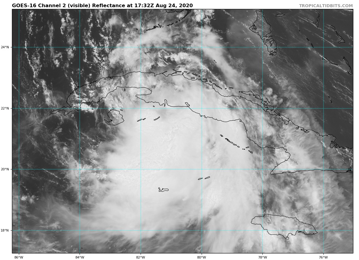
Laura’s Center Passing Near Cayo Largo, Cuba
NHC UPDATE SUMMARY OF 1:00 PM CDT INFORMATION
LOCATION: 25 miles south of Cayo Largo, Cuba
MAXIMUM WINDS: 60 mph
MOVEMENT: west-northwest at 20 MPH
MINIMUM PRESSURE: 1001 MB or 29.56 in
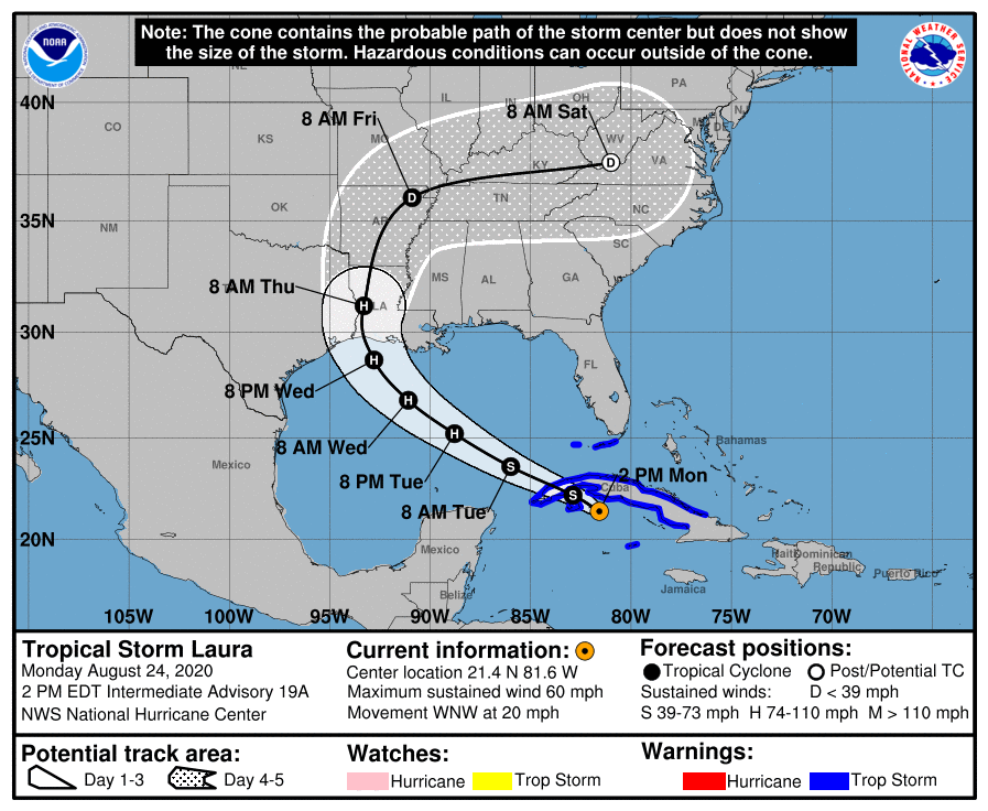
WATCHES AND WARNINGS
A Tropical Storm Warning is in effect for…
* Little Cayman and Cayman Brac
* Cuban provinces of Camaguey, Las Tunas, Ciego De Avila, Sancti Spiritus, Villa Clara, Cienfuegos, Matanzas, Mayabeque, La Habana, Artemisa, Pinar del Rio, and the Isle of Youth
* Florida Keys from Craig Key to Key West
* Dry Tortugas
DISCUSSION AND OUTLOOK
At 200 PM EDT (1800 UTC), the center of Tropical Storm Laura was located near latitude 21.4 North, longitude 81.6 West. Laura is moving toward the west-northwest near 20 mph (31 km/h), and this general motion with some decrease in forward speed is expected over the next day or so. A turn toward the northwest is forecast by Wednesday, and a northwestward to north-northwestward motion should continue through Wednesday night. On the forecast track, the center of Laura will move over the Caribbean Sea just offshore of the southern coast of Cuba this afternoon, cross western Cuba this evening, and move into the southeastern Gulf of Mexico overnight. Laura is then forecast to move over the central and northwestern Gulf of Mexico Tuesday night and Wednesday, and approach the northwestern coast of the Gulf of Mexico Wednesday night.
Maximum sustained winds are near 60 mph (95 km/h) with higher gusts. Little change in strength is forecast today, but strengthening is expected when the storm moves over the Gulf of Mexico. Laura is forecast to become a hurricane on Tuesday, with additional strengthening forecast on Wednesday.
Tropical-storm-force winds extend outward up to 175 miles (280 km) primarily to the northeast and east of the center. An elevated observing site at Sand Key located south of Key West, Florida, has recently reported a wind gust of 41 mph (67 km/h). A wind gust of 47 mph (76 km/h) has been observed at Santa Clara, Cuba, within the past few hours.
The estimated minimum central pressure based on reconnaissance aircraft data is 1001 MB (29.56 inches).
HAZARDS AFFECTING LAND
RAINFALL: Laura is expected to produce the following storm total rainfall accumulations through today:
Jamaica, Cuba, and the Cayman Islands: 4 to 6 inches, with maximum amounts of 10 inches. Across the Greater Antilles, this heavy rainfall could lead to life-threatening flash and urban flooding, and the potential for mudslides.
From Wednesday afternoon into Friday, Laura is expected to produce rainfall of 4 to 8 inches, with isolated maximum amounts of 12 inches across portions of the west-central U.S. Gulf Coast near the Texas and Louisiana border north into portions of the Lower Mississippi Valley. This rainfall could cause widespread flash and urban flooding, small streams to overflow their banks, and minor to isolated moderate river flooding.
WIND: Tropical storm conditions are expected to spread westward within the warning area in Cuba through today. Tropical storm conditions are expected in Little Cayman and Cayman Brac today. Tropical storm conditions are also expected within the warning area in the middle and lower Florida Keys and the Dry Tortugas this afternoon and tonight.
SURF: Swells generated by Laura are affecting portions of Hispaniola, Cuba, the central Bahamas, and the Florida Keys. Swells are expected to spread northward along portions of the west coast of Florida peninsula and the coast of the Florida panhandle on Tuesday and Tuesday night. These swells are likely to cause life-threatening surf and rip current conditions. Please consult products from your local weather office.
TORNADOES: An isolated tornado will be possible later today into tonight across the Florida Keys.
Category: ALL POSTS, Severe Weather, Tropical
About the Author (Author Profile)
Scott Martin is an operational meteorologist, professional graphic artist, musician, husband, and father. Not only is Scott a member of the National Weather Association, but he is also the Central Alabama Chapter of the NWA president. Scott is also the co-founder of Racecast Weather, which provides forecasts for many racing series across the USA. He also supplies forecasts for the BassMaster Elite Series events including the BassMaster Classic.Subscribe
If you enjoyed this article, subscribe to receive more just like it.


