Marco Weakens to a Weak Tropical Storm
NHC UPDATE SUMMARY OF 1:00 PM CDT INFORMATION
LOCATION: 40 miles southeast of the Mouth of the Mississippi River
MAXIMUM WINDS: 40 mph
MOVEMENT: northwest at 6 MPH
MINIMUM PRESSURE: 1008 MB or 29.77 in
WATCHES AND WARNINGS
There are no coastal watches or warnings in effect.
DISCUSSION AND OUTLOOK
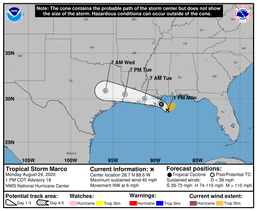
At 100 PM CDT (1800 UTC), the center of Tropical Storm Marco was located near latitude 28.7 North, longitude 88.6 West. Marco is moving toward the northwest near 6 mph (9 km/h). A turn to the west-northwest is expected to occur by Tuesday, and this motion should continue until the system dissipates in a couple of days.
Aircraft and satellite-derived wind data indicate that maximum sustained winds are near 40 mph (65 km/h) with higher gusts. Further weakening is expected, and Marco is forecast to become a tropical depression tonight and degenerate to a remnant low on Tuesday.
Tropical-storm-force winds extend outward up to 80 miles (130 km) to the northeast of the center over water. A National Ocean Service weather station located on Petit Bois Island, Mississippi recently reported a wind gust to 35 mph (58 km/h).
The latest minimum central pressure reported by aircraft reconnaissance is 1008 MB (29.77 inches).
HAZARDS AFFECTING LAND
WIND: Wind gusts to tropical storm force are possible over the coastal sections of southeastern Louisiana and Mississippi through this evening.
RAINFALL: Marco is expected to produce total rainfall accumulations of 2 to 4 inches with isolated maximum amounts of 7 inches across portions of the northeast and north-central Gulf coast through Tuesday. This rainfall may result in areas of flash, urban and small stream flooding along the same area.
SURF: Swells generated by Marco are likely to affect portions of the northern Gulf Coast for the next day or so. These swells are likely to cause life-threatening surf and rip current conditions. Please consult products from your local weather office.
TORNADOES: A couple of tornadoes are possible today into tonight across the Florida Panhandle, southern Georgia, southern Alabama, and southern Mississippi.
Category: ALL POSTS, Severe Weather, Tropical
About the Author (Author Profile)
Scott Martin is an operational meteorologist, professional graphic artist, musician, husband, and father. Not only is Scott a member of the National Weather Association, but he is also the Central Alabama Chapter of the NWA president. Scott is also the co-founder of Racecast Weather, which provides forecasts for many racing series across the USA. He also supplies forecasts for the BassMaster Elite Series events including the BassMaster Classic.Subscribe
If you enjoyed this article, subscribe to receive more just like it.


