Laura is Just Below Hurricane Strength at 7:00 am
NHC UPDATE SUMMARY OF 7:00 AM CDT INFORMATION
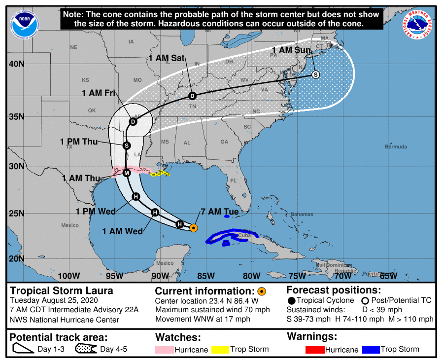
LOCATION: 145 miles northwest of the western tip of Cuba
MAXIMUM WINDS: 70 mph
MOVEMENT: west-northwest at 17 MPH
MINIMUM PRESSURE: 991 MB or 29.26 in
WATCHES AND WARNINGS
A Storm Surge Watch is in effect for…
* San Luis Pass Texas to Ocean Springs Mississippi
* Lake Pontchartrain, Lake Maurepas, and Lake Borgne
A Hurricane Watch is in effect for…
* San Luis Pass Texas to the west of Morgan City Louisiana
A Tropical Storm Warning is in effect for…
* Cuban provinces of Villa Clara, Cienfuegos, Matanzas, Mayabeque, La Habana, Artemisa, Pinar del Rio, and the Isle of Youth
* Dry Tortugas
A Tropical Storm Watch is in effect for…
* San Luis Pass to Freeport Texas
* Morgan City Louisiana to the Mouth of the Mississippi River
DISCUSSION AND OUTLOOK
At 700 AM CDT (1200 UTC), the center of Tropical Storm Laura was located near latitude 23.4 North, longitude 86.4 West. Laura is moving toward the west-northwest near 17 mph (28 km/h), and this general motion should continue today. A turn toward the northwest is forecast by Wednesday, and a northwestward to north-northwestward motion should continue through Wednesday night. On the forecast track, the center of Laura will move away from Cuba and over the southeastern Gulf of Mexico this morning. Laura is then forecast to move over the central and northwestern Gulf of Mexico tonight and Wednesday, approach the Upper Texas and Southwest Louisiana coasts on Wednesday night and move inland near those areas on Thursday.
Reports from an NOAA Hurricane Hunter aircraft indicate that maximum sustained winds have increased to near 70 mph (110 km/h) with higher gusts. Significant strengthening is forecast during the next 48 hours, and Laura is expected to be a major hurricane at landfall.
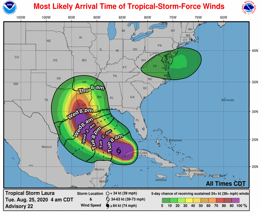
Tropical-storm-force winds extend outward up to 175 miles (280 km) from the center.
The minimum central pressure estimated from the Hurricane Hunter aircraft data is 991 MB (29.26 inches).
HAZARDS AFFECTING LAND
STORM SURGE: The combination of a dangerous storm surge and the tide will cause normally dry areas near the coast to be flooded by rising waters moving inland from the shoreline. The water could reach the following heights above ground somewhere in the indicated areas if the peak surge occurs at the time of high tide…
High Island TX to Morgan City LA including Sabine Lake, Calcasieu Lake, and Vermilion Bay…7-11 ft
Port Bolivar TX to High Island TX…4-6 ft
Morgan City LA to Mouth of the Mississippi River…4-6 ft
The mouth of the Mississippi River to Ocean Springs MS including Lake Borgne…3-5 ft
San Luis Pass TX to Port Bolivar TX…2-4 ft
Galveston Bay…2-4 ft
Lake Pontchartrain and Lake Maurepas…2-4 ft
The deepest water will occur along the immediate coast near and to the right of the landfall location, where the surge will be accompanied by large and destructive waves. Surge-related flooding depends on the relative timing of the surge and the tidal cycle and can vary greatly over short distances. For information specific to your area, please see products issued by your local National Weather Service forecast office.
RAINFALL: Laura is expected to produce the following storm total rainfall accumulations:
Rainfall will be coming to an end across western Cuba this morning with additional rainfall totals of 1 to 2 inches possible.
From Wednesday afternoon into Saturday, Laura is expected to produce rainfall of 4 to 8 inches, with isolated maximum amounts of 12 inches across portions of the west-central U.S. Gulf Coast near the Texas and Louisiana border north into portions of the Lower Mississippi Valley. This rainfall could cause widespread flash and urban flooding, small streams to overflow their banks, and minor to isolated moderate river flooding.
WIND: Tropical storm conditions are expected to continue within the warning area in western Cuba during the next few hours. Tropical storm conditions are also expected for the Dry Tortugas for a few more hours.
Hurricane conditions are possible in the hurricane watch area along the Gulf Coast by late Wednesday, with tropical storm conditions possible by Wednesday afternoon.
SURF: Swells generated by Laura are affecting portions of Cuba, the central Bahamas, and the Florida Keys. Swells are expected to spread northward along portions of the west coast of Florida peninsula and the coast of the Florida panhandle later today and tonight, and reach the northern and northwest Gulf coast by Wednesday. These swells are likely to cause life-threatening surf and rip current conditions. Please consult products from your local weather office.
Category: ALL POSTS, Severe Weather, Tropical
About the Author (Author Profile)
Scott Martin is an operational meteorologist, professional graphic artist, musician, husband, and father. Not only is Scott a member of the National Weather Association, but he is also the Central Alabama Chapter of the NWA president. Scott is also the co-founder of Racecast Weather, which provides forecasts for many racing series across the USA. He also supplies forecasts for the BassMaster Elite Series events including the BassMaster Classic.Subscribe
If you enjoyed this article, subscribe to receive more just like it.


