More Clouds Than Sun on a Muggy Saturday Afternoon
Morning showers and storms have pushed down into South Alabama, and that is where the better rain chances will be for the rest of today. We are seeing more clouds than sun today, and it remains warm and very muggy outside, as temperatures head into the upper 80s and lower 90s across the state today.
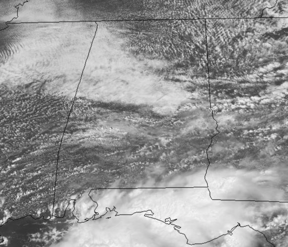
For the northern half of the state, a few showers and storms remain possible, but for the most part, most spots stay dry the rest of today. We do note, there is a severe weather threat just north of the state, and it clips extreme Northwest Alabama, this is associated with a boundary that will impact our forecast in the coming days.
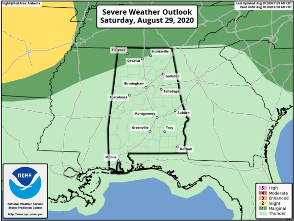
TOMORROW: Rain chances increase tomorrow as a frontal boundary approaches the state from the north. With the added uplift and very moist air mass in place, we are going to see another day with more clouds than sun with scattered to numerous showers and storms. Highs tomorrow will again range from the upper 80s to lower 90s, depending on how much sunshine your location sees. Some stronger storms are possible, but for now, the severe weather threat remains northwest of Alabama.
IN THE TROPICS: Could we be seeing the beginnings of Nana and Omar?
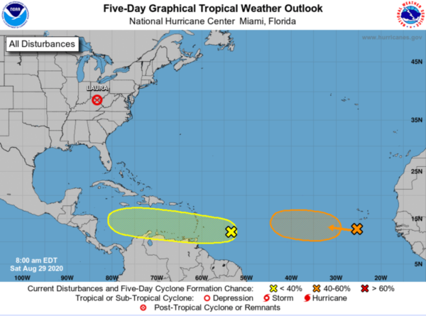
1. A tropical wave located about 550 miles east of the Windward Islands is producing disorganized showers and thunderstorms. Some gradual development of this system is possible during the next several days while it moves westward at about 15 mph toward the Lesser Antilles. Regardless of development, this system will likely produce gusty winds and locally heavy rainfall across portions of the Windward and Leeward Islands on Sunday. Formation chance through 5 days…low…30 percent.
2. Another tropical wave is located over the eastern Atlantic Ocean just southwest of the Cabo Verde Islands. This system is expected to move very slowly for the next several days, and some development is possible early next week over the eastern or central tropical Atlantic. Formation chance through 5 days…medium…40 percent.
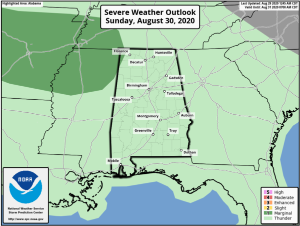
STORMY START TO WEEK: With the frontal boundary essentially stalled across North/Central Alabama, a very moist air mass in place, and several shortwaves working along the front, we look to see numerous showers and storms Monday and Tuesday. These storms could be strong to severe, and the SPC already has much of Alabama in a “marginal risk” for severe storms Monday with the level 2 “slight risk” into West Alabama.
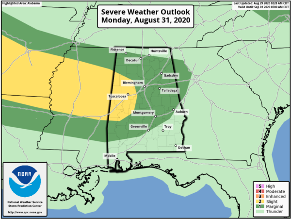
It looks like we could deal with a couple of MCSs (mesoscale convective systems) or thunderstorm complexes developing to the west and riding along the boundary into the state. The main threat with these features would be damaging winds, but we can’t rule out the chance of an isolated tornado with these storms either. So for now, expect a wet go of it at times, with highs in the upper 80s.
REST OF WEEK: The boundary looks to move north out of the state by midweek, and we should see some drier air work into the state from the southwest. We will reduce our rain chances to the 20-30% range for Wednesday through Friday. The days should feature a mix of sun and clouds, a few afternoon showers/storms, and highs in the 88 and 92 range, pretty close to seasonal averages for early September. We do note, to our west, there will be an upper-level cut-off low, and if it can slide to the east some, we may have to increase our rain chances accordingly, but for now the ridge off the Southeast coast looks to keep that feature far enough to the west.
BEACH FORECAST CENTER: Get the latest weather and rip current forecasts for the beaches from Fort Morgan to Panama City on our Beach Forecast Center page. There, you can select the forecast of the region that you are interested in visiting.
WORLD TEMPERATURE EXTREMES: Over the last 24 hours, the highest observation outside the U.S. was 116.6F at Ejido Nuevo Leon, Mexico. The lowest observation was -98.1F at Dome C, Antarctica.
CONTIGUOUS TEMPERATURE EXTREMES: Over the last 24 hours, the highest observation was 118F Topock, AZ. The lowest observation was 25F at Choteau, MT.
WEATHER ON THIS DATE IN 1962: Hackberry, LA, was deluged with twenty-two inches of rain in 24 hours, establishing a state record. Hackberry, was actually impacted by Laura this week, as the town is just south of Lake Charles and was in the eyeball and eye of Laura as it made landfall. There is tremendous amounts of damage in the area.
Category: Alabama's Weather, ALL POSTS
About the Author (Author Profile)
Macon, Georgia Television Chief Meteorologist, Birmingham native, and long time Contributor on AlabamaWX. Stormchaser. I did not choose Weather, it chose Me. College Football Fanatic. @Ryan_StinnetSubscribe
If you enjoyed this article, subscribe to receive more just like it.


