Seven Areas in the Tropics Being Watched by the NHC
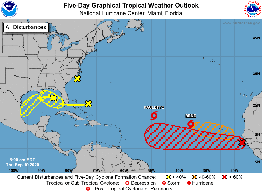
The latest Tropical Weather Outlook from the National Hurricane Center has identified seven areas that need to be watched in the tropics over the next five days. The main systems out there are tropical storms Paulette and Rene, but they are out in the open waters and should only be a problem to the fish. Unfortunately, Paulette may make a run at Bermuda starting on Monday. Update posts on those two systems will be out in later posts. Now let’s get to the other five areas of concern.
Yellow X over the Gulf of Mexico
A trough of low pressure has developed over the northeastern Gulf of Mexico and is producing a few disorganized showers and thunderstorms. Some slow development of this system is possible while this system moves westward and then southwestward over the northern and western Gulf of Mexico through early next week.
* Formation chance through 48 hours…low…10 percent.
* Formation chance through 5 days…low…20 percent.
Yellow X near the Bahamas
A large area of disorganized showers and thunderstorms centered a couple of hundred miles northeast of the Central Bahamas is associated with a surface trough of low pressure. This system is forecast to move westward, crossing the Bahamas and Florida on Friday and moving into the eastern Gulf of Mexico over the weekend. Upper-level winds are expected to become conducive for some development of this system while it moves slowly west-northwestward over the eastern Gulf of Mexico early next week.
* Formation chance through 48 hours…low…near 0 percent.
* Formation chance through 5 days…low…30 percent.
Yellow X near the Carolinas
A trough of low pressure located just off the coast of North Carolina is producing minimal shower and thunderstorm activity. This system is expected to move inland over eastern North Carolina this afternoon, and therefore significant development is not expected.
* Formation chance through 48 hours…low…near 0 percent.
* Formation chance through 5 days…low…near 0 percent.
Red X near Africa
A tropical wave is now moving off the west coast of Africa, producing a large area of showers and thunderstorms. Gradual development of this system is forecast, and a tropical depression is expected to form by this weekend or early next week while the system moves generally westward across the eastern and central tropical Atlantic.
* Formation chance through 48 hours…medium…60 percent.
* Formation chance through 5 days…high…90 percent.
Orange hatched area near Africa
A tropical wave is forecast to emerge off the west coast of Africa this weekend. Environmental conditions are expected to be conducive for development, and a tropical depression could form over the far eastern tropical Atlantic Ocean early next week while the system moves slowly westward.
* Formation chance through 48 hours…low…near 0 percent.
* Formation chance through 5 days…medium…40 percent.
About the Author (Author Profile)
Scott Martin is an operational meteorologist, professional graphic artist, musician, husband, and father. Not only is Scott a member of the National Weather Association, but he is also the Central Alabama Chapter of the NWA president. Scott is also the co-founder of Racecast Weather, which provides forecasts for many racing series across the USA. He also supplies forecasts for the BassMaster Elite Series events including the BassMaster Classic.Subscribe
If you enjoyed this article, subscribe to receive more just like it.


