

Paulette Expected to Approach Bermuda as a Hurricane Early Next Week
SUMMARY OF 4:00 PM CDT…2100 UTC…INFORMATION
———————————————-
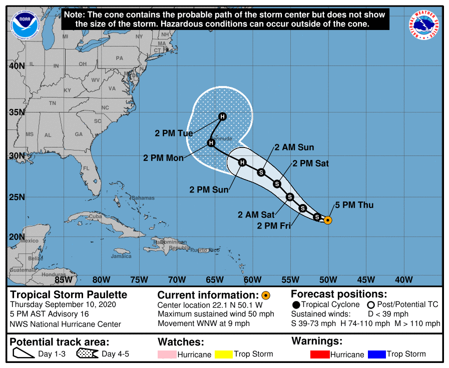
LOCATION…22.1N 50.1W
ABOUT 885 MI…1425 KM ENE OF THE NORTHERN LEEWARD ISLANDS
ABOUT 1145 MI…1840 KM SE OF BERMUDA
MAXIMUM SUSTAINED WINDS…50 MPH…85 KM/H
PRESENT MOVEMENT…WNW OR 300 DEGREES AT 9 MPH…15 KM/H
MINIMUM CENTRAL PRESSURE…997 MB…29.44 INCHES
WATCHES AND WARNINGS
——————–
There are no coastal watches or warnings in effect.
Interests in Bermuda should monitor the progress of Paulette. Please consult products from your local weather office.

DISCUSSION AND OUTLOOK
———————-
At 4:00 PM CDT (2100 UTC), the center of Tropical Storm Paulette was located near latitude 22.1 North, longitude 50.1 West. Paulette is moving toward the west-northwest near 9 mph (15 km/h). A west-northwestward or northwestward motion with some increase in forward speed is expected through the weekend.
Maximum sustained winds are near 50 mph (85 km/h) with higher gusts. Some slight weakening is expected during the next day or so, but Paulette is then forecast to restrengthen by Saturday. Paulette is expected to become a hurricane by Sunday.
Tropical-storm-force winds extend outward up to 205 miles (335 km) from the center.
The estimated minimum central pressure is 997 MB (29.44 inches).
HAZARDS AFFECTING LAND
———————-
SURF: Swells generated by Paulette are expected to reach portions of the Leeward Islands tonight and Friday and will continue to spread westward to portions of the Greater Antilles, Bahamas, Bermuda, and the southeastern United States into the weekend. These swells are likely to cause life-threatening surf and rip current conditions.
About the Author (Author Profile)
Scott Martin is an operational meteorologist, professional graphic artist, musician, husband, and father. Not only is Scott a member of the National Weather Association, but he is also the Central Alabama Chapter of the NWA president. Scott is also the co-founder of Racecast Weather, which provides forecasts for many racing series across the USA. He also supplies forecasts for the BassMaster Elite Series events including the BassMaster Classic.Subscribe
If you enjoyed this article, subscribe to receive more just like it.


