Tropical Depression 19 – Saturday Morning Update
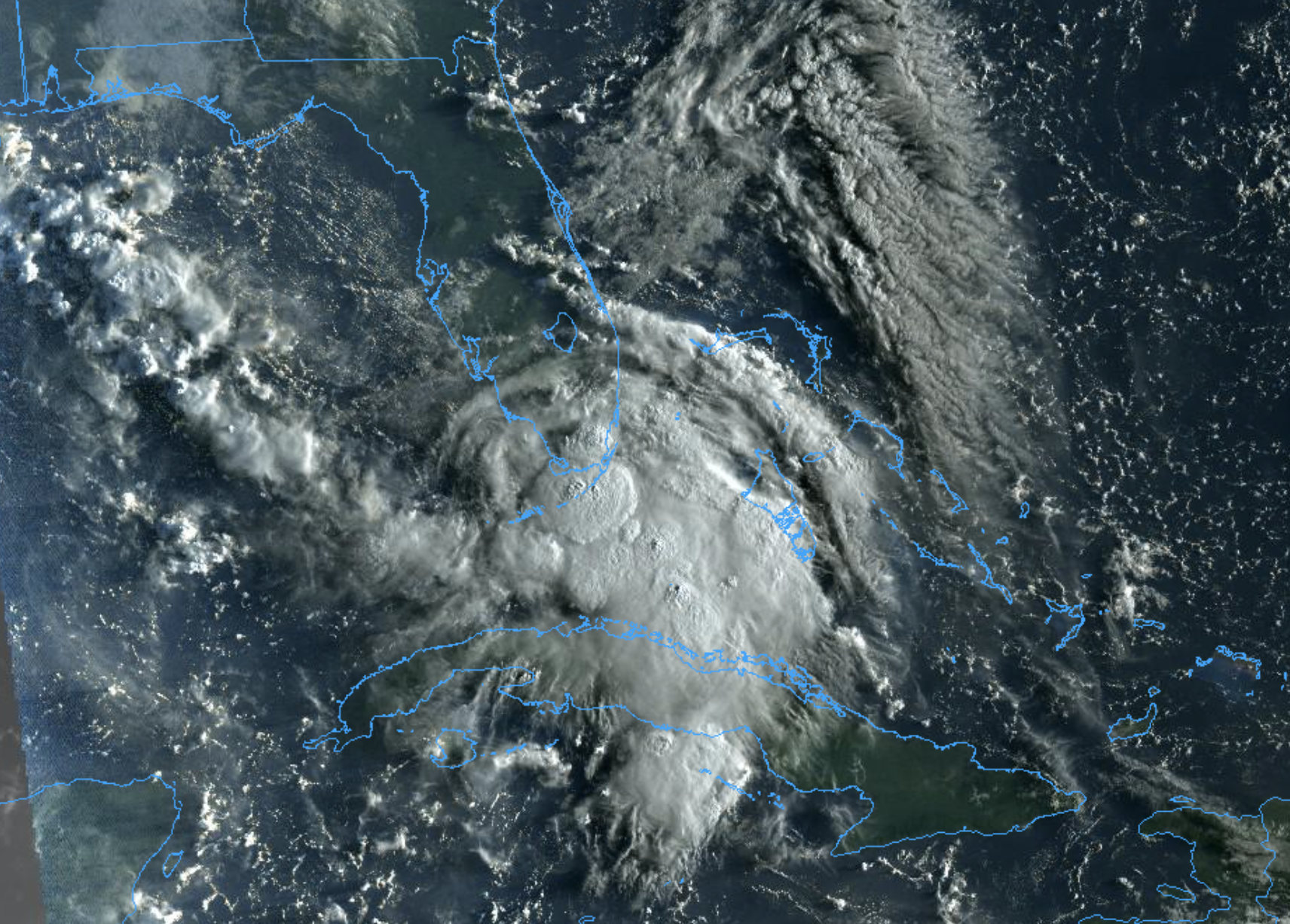
The center of TD 19 this morning is over the southern tip of Florida, just west of Miami. Winds remain at 35 mph, and the system is moving to the west at 9 mph. The center will move out into the Gulf of Mexico later today, and TD 19 is expected to become Tropical Storm Sally within the next 12 to 18 hours.
There is little change in the NHC forecast track this morning; the system is expected to remain below hurricane strength, and will pass south of the Florida Panhandle and the Alabama coast, moving into Southeast Louisiana/South Mississippi Tuesday night. Don’t focus on the exact details of the track or intensity forecast as the average NHC track error at 96 hours is around 150 miles and the average intensity error is around 15 mph. In addition, winds, storm surge, and rainfall hazards willextend far from the center.
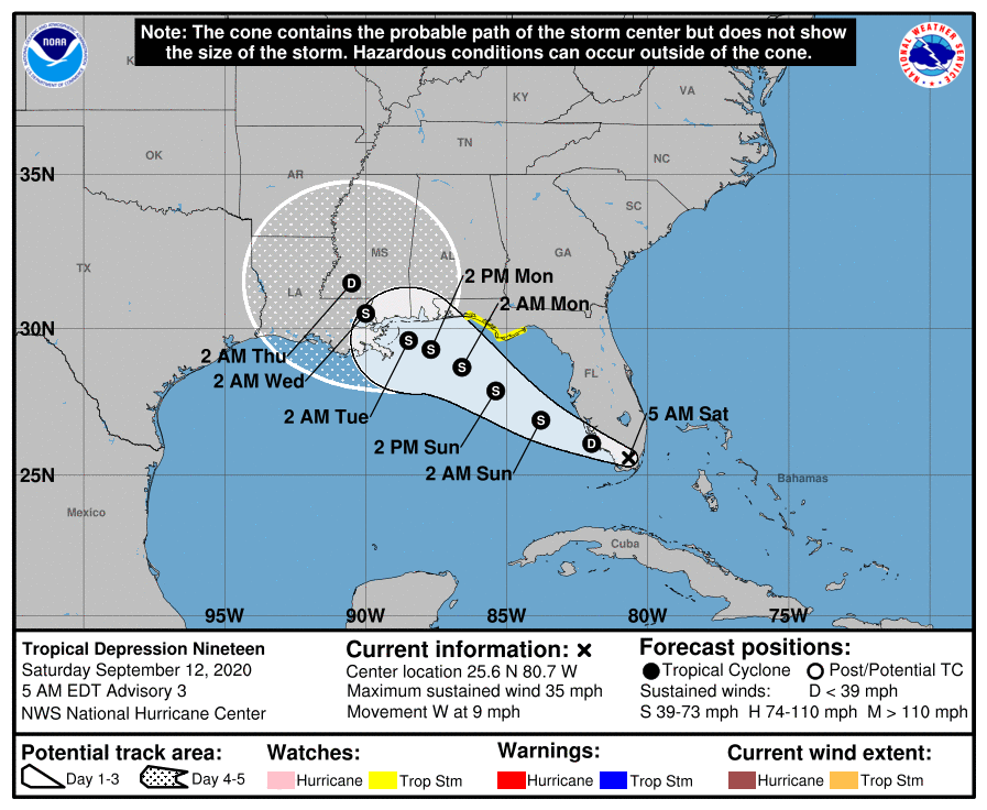
A Tropical Storm Watch is in effect from the Ochlockonee River to the Okaloosa/Walton County Line.
The depression is currently experiencing some northerly vertical wind shear, and the latest global model runs are showing more shear affecting the system as it crosses the Gulf of Mexico than earlier. However, since the cyclone is going to be over very warm sea surface temperatures and in a moist environment, the intensity guidance still shows it strengthening to near hurricane strength, or stronger, before it reaches the northern Gulf coast. So understand forecast changes are possible later today. Everyone on the Gulf Coast will need to pay attention to updates; I will not be surprised if a hurricane watch is issued for the Central Gulf Coast later today.
GULF COAST IMPACT: This discussion is specific to that part of the Gulf Coast from Dauphin Island east to Panama City Beach. The weather won’t be too bad today and a decent part of the day tomorrow with a partly sunny sky and a passing shower or storm from time to time. Conditions will deteriorate tomorrow night as the tropical system gets closer.
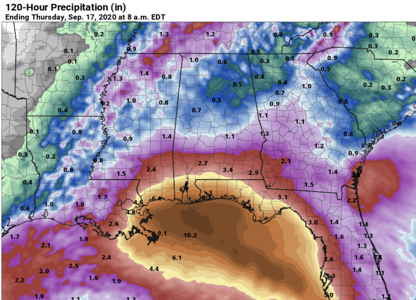
Rain amounts of 2-5 inches are likely; most of the rain directly associated with the system will come Monday and Tuesday. Very high precipitable water values will mean potential for some flooding issues. But, understand the rain won’t be continuous… there will be some breaks in between the rain bands each day.
Winds will be in the 15-35 mph range Monday, with gusts possible to 45 mph (based on the current intensity and track forecast). This could change if the intensity forecast is more aggressive.
A few isolated waterspouts, or brief tornadoes, are possible along the coast Monday and Monday night.
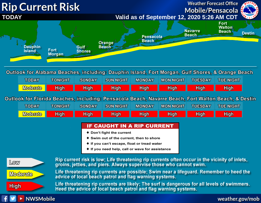
Dangerous rip currents are likely along the coast through at least Tuesday night. Expect red or double red flags.
As usual in this situation, I get the question “Do I need to cancel my beach trip???”. I really can’t answer that one since different people go to the beach for different reasons. I would not hesitate to go, but then again I go mainly for the seafood and the hope of seeing a waterspout one day. If you are going exclusively for sun and to swim in the ocean, Monday and Tuesday won’t be your kind of day. The weather will improve along the coast during the latter half of the week, Wednesday through Friday, with the usual mix of sun and scattered storms.
INLAND IMPACT: The heaviest rain in Alabama associated with the tropical system will be generally south of U.S. 84 (south of a line from Grove Hill to Evergreen to Dothan). Rain amounts there will be in the 1-3 inch range. Amounts will be much lighter over the northern half of the state; generally under one inch.
Again, stay tuned for updates throughout the weekend!
Category: Alabama's Weather, Tropical
About the Author (Author Profile)
James Spann is one of the most recognized and trusted television meteorologists in the industry. He holds the AMS CCM designation and television seals from the AMS and NWA. He is a past winner of the Broadcast Meteorologist of the Year from both professional organizations.Subscribe
If you enjoyed this article, subscribe to receive more just like it.


