Tropical Storm Sally – Monday Midday Update
Tropical Storm Sally is about 185 miles southeast of Biloxi, Mississippi this morning with winds of 65 mph…. moving west/northwest at only 6 mph. NHC is forecasting Sally to become a category one hurricane later today, it will be near the mouth of the Mississippi River late tonight. From there it turns north, and slowly moves into the Mississippi coast tomorrow evening. NHC has nudged the forecast track slightly to the east late this morning.
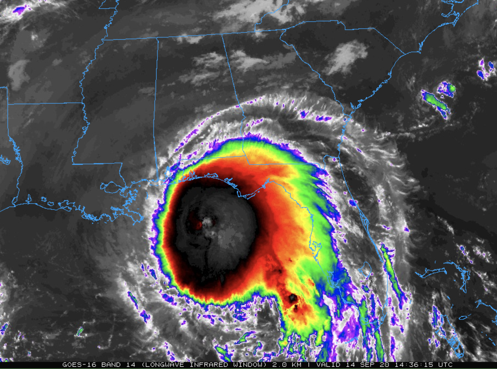

The remnant circulation will turn move east/northeast into Central Alabama Wednesday night. Don’t focus on the details of the official forecast track; dangerous storm surge, rainfall, and wind hazards will extend well away from the center. We note NHC has extended the hurricane warning to now include all of the Alabama Gulf Coast.
A Storm Surge Warning is in effect for…
* Port Fourchon Louisiana to the Alabama/Florida Border
* Lake Pontchartrain, Lake Maurepas, and Lake Borgne
* Mobile Bay
A Hurricane Warning is in effect for…
* Morgan City Louisiana to the Alabama/Florida border, including all of the Alabama Gulf Coast
* Lake Pontchartrain and Lake Maurepas including metropolitan New Orleans
A Tropical Storm Warning is in effect for…
* Alabama/Florida Border to Indian Pass Florida
* Intracoastal City Louisiana to west of Morgan City
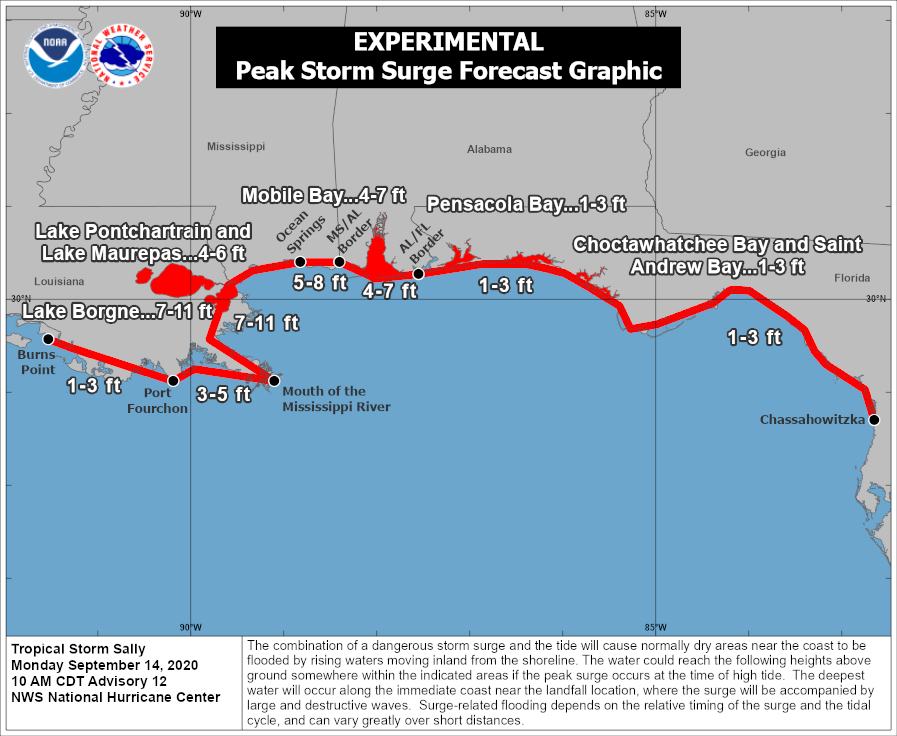
STORM SURGE: The combination of a dangerous storm surge and the tide will cause normally dry areas near the coast to be flooded by rising waters moving inland from the shoreline. The water could reach the following heights above ground somewhere in the indicated areas if the peak surge occurs at the time of high tide…
Mouth of the Mississippi River to Ocean Springs, MS including Lake Borgne…7-11 ft
Ocean Springs, MS to MS/AL Border…5-8 ft
The Alabama Gulf Coast, including Mobile Bay…4-7 ft
Lake Pontchartrain and Lake Maurepas…4-6 ft
Port Fourchon, LA to Mouth of the Mississippi River…3-5 ft
AL/FL Border to Chassahowitzka, FL including Pensacola Bay, Choctawhatchee Bay, and Saint Andrew Bay…1-3 ft
Burns Point, LA to Port Fourchon, LA…1-3 ft
WIND: Sustained winds of 40-60 mph are likely along the Alabama Gulf Coast tonight and tomorrow, with gusts to 80 mph possible. Sustained winds from Pensacola Beach to Panama City Beach will be 20-40 mph, with gusts to 50 mph possible.
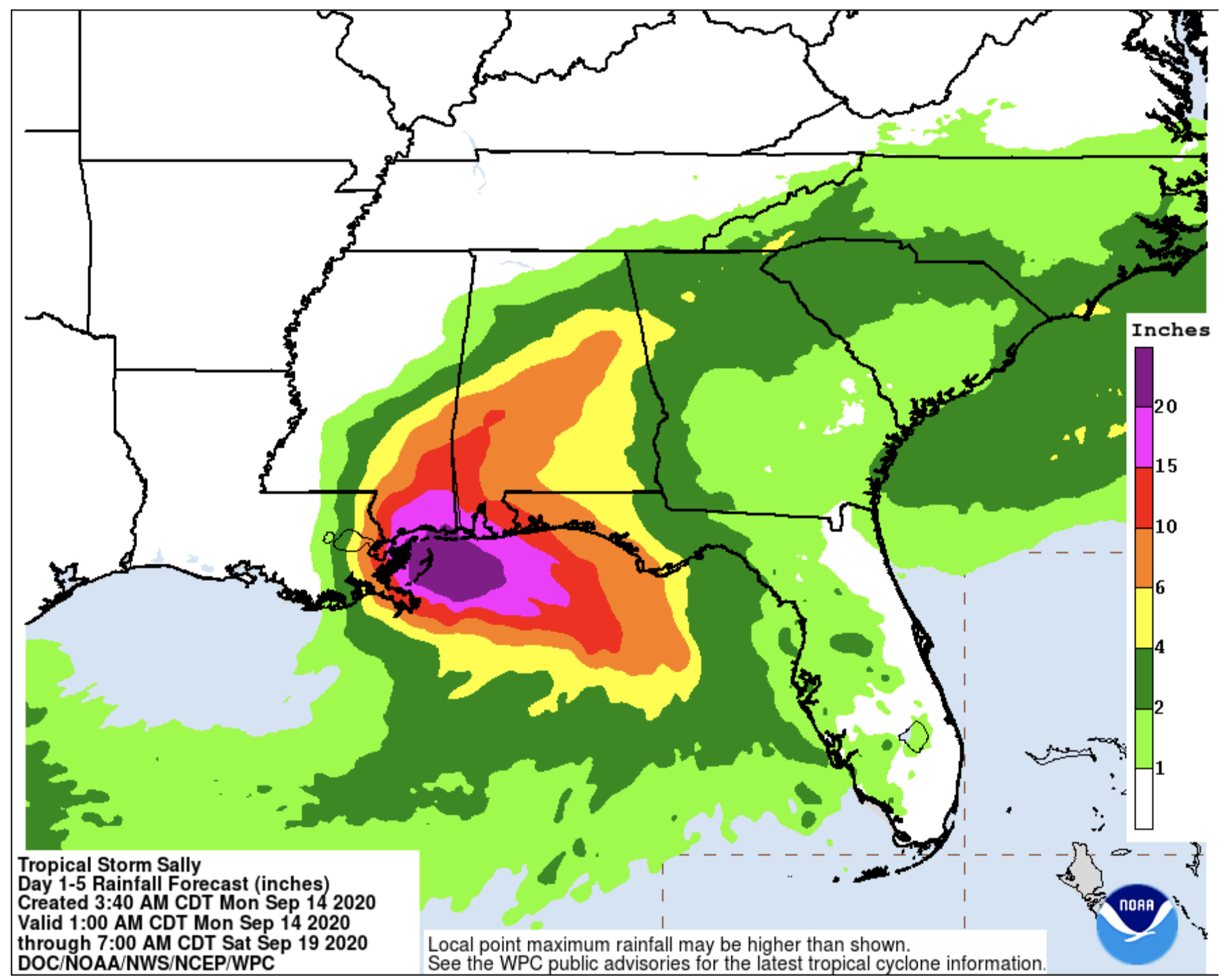
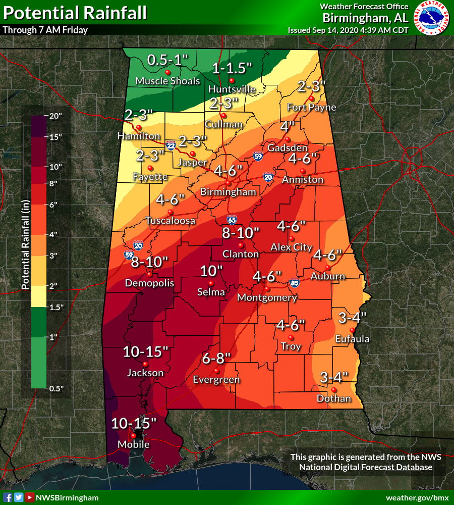
RAIN: Sally is expected to be a slow-moving system as it approaches land producing 8 to 16 inches of rainfall with isolated amounts of 24 inches over portions of the central Gulf Coast from the western Florida Panhandle to far southeast Louisiana through the middle of the week. Life-threatening flash flooding is possible. In addition, this rainfall will likely lead to widespread minor to isolated major flooding on area rivers.
Sally is forecast to turn inland early Wednesday with rainfall of 6 to 12 inches possible across portions of inland southeast Mississippi and Alabama. Significant flash and urban flooding is likely, as well as widespread minor to moderate flooding on some rivers.
A flash flood watch is in effect for much of Central and South Alabama.
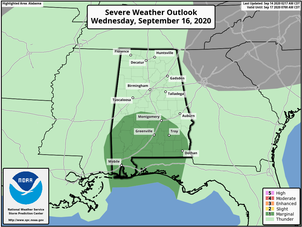
TORNADOES: A brief waterspout, and a tornado or two may occur this afternoon through Tuesday over coastal areas of the Florida Panhandle, Mississippi, Alabama, and extreme southeastern Louisiana.
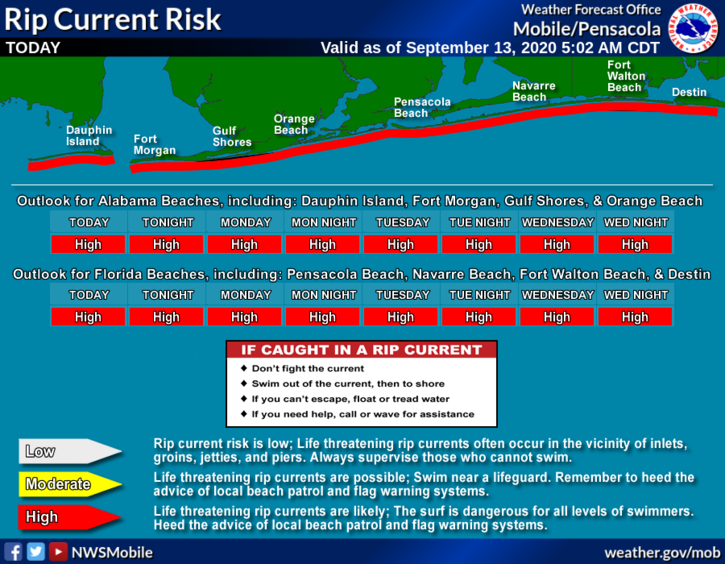
SURF: Swells from Sally are affecting the west coast of the Florida peninsula westward through the coast of Alabama, and will be spreading northwestward along the northern Gulf coast through today. These swells are likely to cause life-threatening surf and rip current conditions.
INLAND ALABAMA: The main impact will be heavy rain and the risks of flooding; rain amounts of 5-10 inches are likely over the western half of the state, with 4-6 inches over the eastern counties. Totals will be lighter over the Tennessee Valley, generally under one inch. The most widespread rain will come tomorrow night, Wednesday, and into Thursday morning. Winds of 15-30 mph are likely Wednesday into early Thursday, and an isolated tornado can’t be totally ruled out Wednesday over the southern half of the state, but for now the risk looks low due to the lack of instability.
Stay tuned for updates!
About the Author (Author Profile)
James Spann is one of the most recognized and trusted television meteorologists in the industry. He holds the AMS CCM designation and television seals from the AMS and NWA. He is a past winner of the Broadcast Meteorologist of the Year from both professional organizations.Subscribe
If you enjoyed this article, subscribe to receive more just like it.


