The Tropics at 10:00 am: Sally is Post-Tropical, Teddy Strengthens into a Category 3 Hurricane
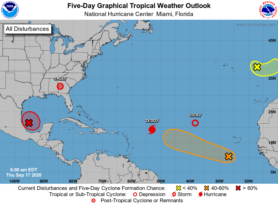
POST-TROPICAL CYCLONE SALLY
At 10:00 AM CDT (1500 UTC), the center of Post-Tropical Cyclone Sally was located near latitude 32.6 North, longitude 84.4 West, or about 115 miles southwest of Athens, GA. The post-tropical cyclone is moving toward the northeast near 21 mph and this motion is expected to continue through this afternoon with a gradual increase in forward speed. Maximum sustained winds are near 30 mph with higher gusts. Little change in strength is forecast during the next 48 hours.
Flash Flood Watches are in effect from northeast Georgia across much of Upstate South Carolina, most of North Carolina, and southeast Virginia. Sally is expected to deposit 4 to 6 inches, with isolated amounts of 10 inches in and near the Carolinas and southern Virginia. Widespread flash flooding and minor to moderate river flooding is likely.
A Tornado Watch is posted across portions of central and northeast South Carolina. Scattered tornadoes may occur from southeast Georgia into South and North Carolina through this afternoon and into this evening.
MAJOR HURRICANE TEDDY
The center of Hurricane Teddy was located near latitude 19.3 North, longitude 53.0 West, or about 610 miles east-northeast of The Lesser Antilles. Teddy is moving toward the northwest near 12 mph and this motion is expected to continue for the next few days. Maximum sustained winds are near 120 mph with higher gusts. Teddy is a category 3 hurricane on the Saffir-Simpson Hurricane Wind Scale. Some additional strengthening is possible through tonight. A slow weakening trend is expected to begin over the weekend. On the forecast track, Teddy may make impacts in Bermuda starting on Sunday morning and continue through late Monday night.
TROPICAL DEPRESSION VICKY
The center of Tropical Depression Vicky was located near latitude 21.4 North, longitude 38.2 West, or about 1000 miles west-northwest of the Cabo Verde Islands. The depression is moving toward the west near 14 mph. A turn toward the west-southwest is expected later today, and that motion should continue through Friday. Satellite wind data indicate that the maximum sustained winds have decreased to near 35 mph with higher gusts. Additional weakening is forecast during the next day or so, and Vicky is expected to become a remnant low later today, and forecast to dissipate Friday night or early Saturday.
INVEST 90L (POTENTIALLY WILFRED)
Thunderstorm activity has continued to increase and become better organized this morning in association with a well-defined low-pressure system located over the southwestern Gulf of Mexico. Upper-level winds are gradually becoming more conducive for development and, if this recent development trend continues, a tropical depression or a tropical storm could form later today. The low is expected to meander over the southwestern Gulf of Mexico for the next day or so before moving slowly northward to northeastward on Friday and Saturday. An Air Force Reserve reconnaissance aircraft is scheduled to investigate the disturbance this afternoon.
* Formation chance through 48 hours…high…90 percent.
* Formation chance through 5 days…high…90 percent.
INVEST 98L
An elongated area of low pressure located a few hundred miles south-southwest of the Cabo Verde Islands is producing disorganized shower and thunderstorm activity. Environmental conditions are expected to be conducive for development during the next few days, and a tropical depression could form before upper-level winds become less favorable over the weekend. The low is forecast to move west-northwestward at 10 to 15 mph during the next several days.
* Formation chance through 48 hours…medium…40 percent.
* Formation chance through 5 days…medium…50 percent.
INVEST 99L
Showers and thunderstorms have become more concentrated this morning in association with a non-tropical area of low pressure located over the far northeastern Atlantic Ocean several hundred miles east of the Azores. Some additional subtropical development is possible over the next day or so as it moves east-southeastward and then northeastward at about 10 mph. The system is expected to reach the coast of Portugal late Friday. For more information on this system, see High Seas Forecasts issued by Meteo France.
* Formation chance through 48 hours…low…30 percent.
* Formation chance through 5 days…low…30 percent.
About the Author (Author Profile)
Scott Martin is an operational meteorologist, professional graphic artist, musician, husband, and father. Not only is Scott a member of the National Weather Association, but he is also the Central Alabama Chapter of the NWA president. Scott is also the co-founder of Racecast Weather, which provides forecasts for many racing series across the USA. He also supplies forecasts for the BassMaster Elite Series events including the BassMaster Classic.Subscribe
If you enjoyed this article, subscribe to receive more just like it.


