Lightning Causing Issues & Paulette Might Regain Tropical Characteristics… Some Tropical News & Notes at 10:00 am
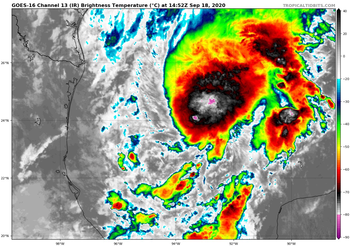
While TD-22 in the western Gulf of Mexico continues to get better organized, it may have beaten the disturbance out in the Atlantic to get the name “Wilfred,” but there were some technical difficulties. Here is the last sentence from the first paragraph from the 10:00 am forecast discussion from the NHC:
“It should be noted that the Air Force Reserve Hurricane Hunter aircraft that was scheduled to investigate the depression had to turn back after getting hit by lightning.”
So, at this point, the NHC is going with the latest CIMSS (Cooperative Institute for Meteorological Satellite Studies) satellite consensus and keeping the wind speeds at strong depression strength. Another plane is scheduled to investigate TD-22 later this afternoon. More than likely, we’ll have Tropical Storm Alpha in the Gulf.

Hurricane Teddy remains at category 3 strength with maximum sustained winds at 130 MPH. At this point, he is moving to the northwest at 12 MPH, but a turn to the north is expected starting Sunday morning. Unfortunately, Bermuda may see major impacts from Teddy if the track stays similar to what is shown at 10:00 am this morning.
It may be possible that Teddy could make landfall on Nova Scotia on the eastern edge of Canada as a weakening hurricane on late Tuesday. If that occurs, it will be the first hurricane to make landfall on Nova Scotia since Hurricane Earl struck the town of Western Head on September 3rd, 2010 as a minimal hurricane. Earl caused minor coastal flooding, widespread power outages, and fallen trees.
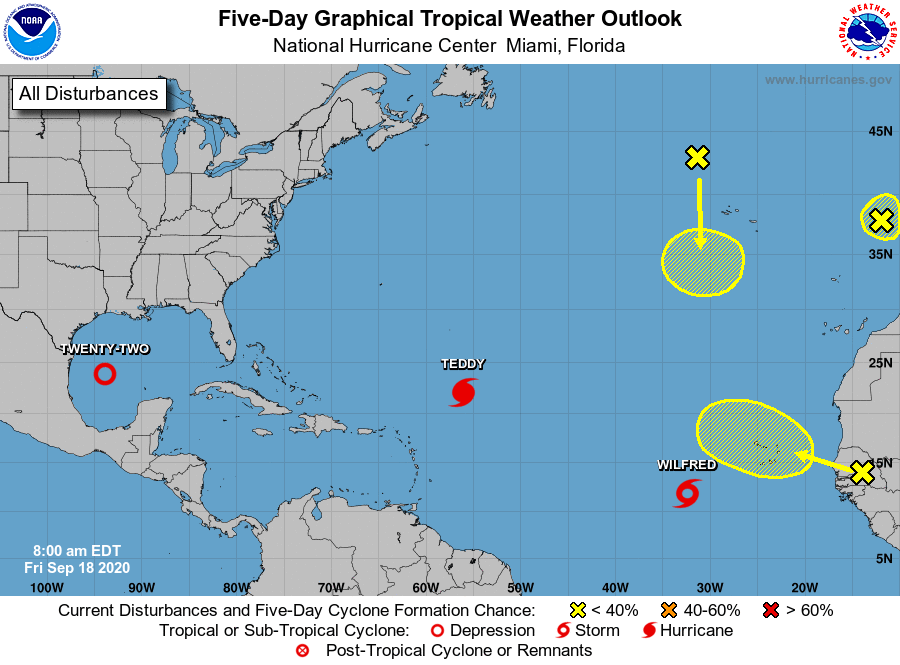
We also have three other areas that are being watched by the NHC and a fourth that is not on the map as of yet. Here is the latest information from the 7:00 am CDT Tropical Weather Outlook:
1. Showers and thunderstorms associated with an area of low pressure located a few hundred miles southwest of the Cabo Verde Islands are becoming better organized. Earlier satellite-derived wind data indicated that this system does not yet have a well-defined center, but it is producing winds near tropical-storm-force to its east. Environmental conditions are expected to be conducive for additional development during the next day or two and a tropical depression or tropical storm is likely to form before the end of the week. This system is forecast to move west-northwestward at 10 to 15 mph through the weekend. For more information on this system, please see High Seas Forecasts issued by the National Weather Service.
* Formation chance through 48 hours…high…70 percent.
* Formation chance through 5 days…high…70 percent.
2. A small low-pressure system located just west of the coast of Portugal is embedded within a larger non-tropical low. Although showers and thunderstorms associated with the smaller low are showing signs of organization, the system will soon move inland over Portugal and further tropical or subtropical development is unlikely. The low is producing gale-force winds, and will likely bring gusty winds and brief periods of heavy rain to portions of western Portugal today and tonight. For more information about potential hazards in Portugal, please see products issued by the Portuguese Institute for the Sea and the Atmosphere (IPMA). For more information about marine hazards associated with this system, see High Seas Forecasts issued by Meteo France.
* Formation chance through 48 hours…low…20 percent.
* Formation chance through 5 days…low…20 percent.
3. Post-tropical cyclone Paulette is located several hundred miles north-northwest of the Azores. The cyclone is forecast to move quickly southward for the next few days and then stall over marginally warm waters a few hundred miles south or south-southwest of the Azores by the end of the weekend. The cyclone could subsequently redevelop tropical characteristics late this weekend or early next week while it moves little.
* Formation chance through 48 hours…low…20 percent.
* Formation chance through 5 days…low…30 percent.
4. Another tropical wave is forecast to move off the west coast of Africa by early Saturday. Some gradual development of the system will be possible thereafter while it moves generally west-northwestward over the far eastern Atlantic.
* Formation chance through 48 hours…low…near 0 percent.
* Formation chance through 5 days…low…20 percent.
About the Author (Author Profile)
Scott Martin is an operational meteorologist, professional graphic artist, musician, husband, and father. Not only is Scott a member of the National Weather Association, but he is also the Central Alabama Chapter of the NWA president. Scott is also the co-founder of Racecast Weather, which provides forecasts for many racing series across the USA. He also supplies forecasts for the BassMaster Elite Series events including the BassMaster Classic.Subscribe
If you enjoyed this article, subscribe to receive more just like it.


