Beta Seems to be Struggling a Little as of 7:00 am, Remains a Strong Tropical Storm
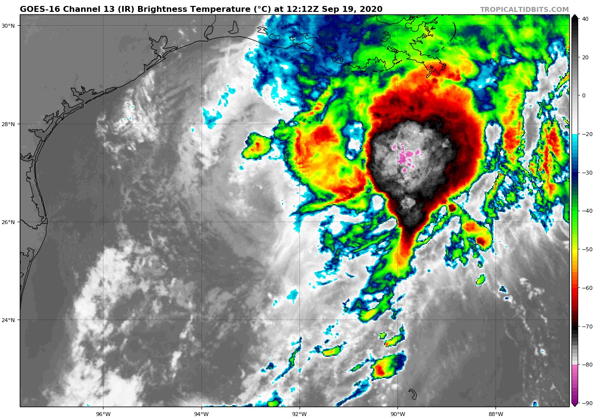
AIR FORCE RESERVE HURRICANE HUNTER AIRCRAFT INVESTIGATING BETA
SUMMARY OF 700 AM CDT…1200 UTC…INFORMATION
———————————————-
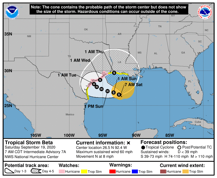
LOCATION…26.5N 92.4W
ABOUT 290 MI…470 KM E OF MOUTH OF THE RIO GRANDE
ABOUT 270 MI…435 KM SW OF THE MOUTH OF THE MISSISSIPPI RIVER
MAXIMUM SUSTAINED WINDS…60 MPH…95 KM/H
PRESENT MOVEMENT…N OR 360 DEGREES AT 8 MPH…13 KM/H
MINIMUM CENTRAL PRESSURE…995 MB…29.38 INCHES
WATCHES AND WARNINGS
——————–
A Storm Surge Watch is in effect for…
* Port Mansfield, TX to Cameron, LA including Baffin Bay, Corpus Christi Bay, Copano Bay, Aransas Bay, San Antonio Bay, Matagorda Bay, Galveston Bay, Sabine Lake, and Calcasieu Lake
A Hurricane Watch is in effect for…
* Port Aransas Texas to High Island Texas
A Tropical Storm Watch is in effect for…
* South of Port Aransas Texas to the Mouth of the Rio Grande
* East of High Island Texas to Morgan City Louisiana
DISCUSSION AND OUTLOOK
———————-
At 700 AM CDT (1200 UTC), the center of Tropical Storm Beta was located near latitude 26.5 North, longitude 92.4 West. Beta is moving toward the north near 8 mph (13 km/h). A slow westward motion is expected to begin late today, with a slow northwestward motion forecast to begin late Sunday and continue through late Monday. On the forecast track, the center of Beta will slowly approach the Texas coast into early next week.
Maximum sustained winds are near 60 mph (95 km/h) with higher gusts. Slow strengthening is forecast, and Beta is expected to become a hurricane on Sunday.
Tropical-storm-force winds extend outward up to 175 miles (280 km) from the center.
The minimum central pressure reported by an Air Force Reserve Hurricane Hunter aircraft is 995 MB (29.38 inches).
HAZARDS AFFECTING LAND
———————-
STORM SURGE: The combination of a dangerous storm surge and the tide will cause normally dry areas near the coast to be flooded by rising waters moving inland from the shoreline. The water could reach the following heights above ground somewhere in the indicated areas if the peak surge occurs at the time of high tide…
* Port Mansfield, TX to Cameron, LA including Baffin Bay, Corpus Christi Bay, Copano Bay, Aransas Bay, San Antonio Bay, Matagorda Bay, Galveston Bay, Sabine Lake, and Calcasieu Lake…2-4 ft
* The mouth of the Rio Grande, TX to Port Mansfield, TX…1-3 ft
* Cameron, LA to Morgan City, LA including Vermilion Bay…1-3 ft
The deepest water will occur along the immediate coast in areas of onshore winds, where the surge will be accompanied by large and destructive waves. Surge-related flooding depends on the relative timing of the surge and the tidal cycle and can vary greatly over short distances. For information specific to your area, please see products issued by your local National Weather Service forecast office.
WIND: Hurricane conditions are possible within the hurricane watch area by late Monday or Monday night, with tropical storm conditions possible by late Sunday. Tropical storm conditions are possible within the tropical storm watch area along the upper Texas and southwestern Louisiana coast as early as tonight. Tropical storm conditions are possible within the tropical storm watch area along the south Texas coast late Sunday.
RAINFALL: There is an increasing risk of significant rainfall and flooding along the Texas and Louisiana coasts from Sunday through at least the middle of next week as Beta is forecast to move slowly near the Texas coast. For additional information, see products from your local National Weather Service office.
SURF: Swells are expected to increase and reach the coast of Texas and the Gulf Coast of Mexico later today, generated by a combination of Beta and a cold front entering the northern Gulf of Mexico. These swells are likely to cause life-threatening surf and rip current conditions. Please consult products from your local weather office.
Category: ALL POSTS, Severe Weather, Tropical
About the Author (Author Profile)
Scott Martin is an operational meteorologist, professional graphic artist, musician, husband, and father. Not only is Scott a member of the National Weather Association, but he is also the Central Alabama Chapter of the NWA president. Scott is also the co-founder of Racecast Weather, which provides forecasts for many racing series across the USA. He also supplies forecasts for the BassMaster Elite Series events including the BassMaster Classic.Subscribe
If you enjoyed this article, subscribe to receive more just like it.


