Teddy Drops Back Down to Strong Category 3 Status; Bermuda Under a Tropical Storm Warning
TROPICAL STORM WARNING IN EFFECT FOR BERMUDA
LARGE SWELLS THAT CAN CAUSE RIP CURRENTS WILL AFFECT MOST WESTERN ATLANTIC COASTS THROUGH THE WEEKEND
SUMMARY OF 800 AM AST…1200 UTC…INFORMATION
———————————————-
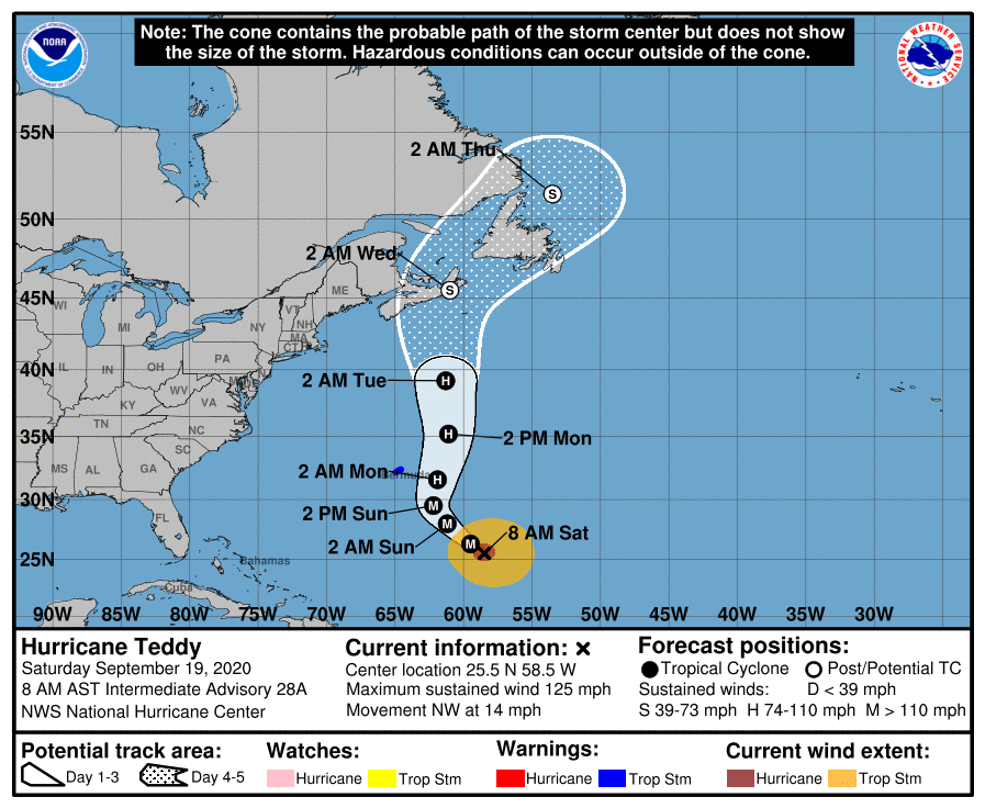
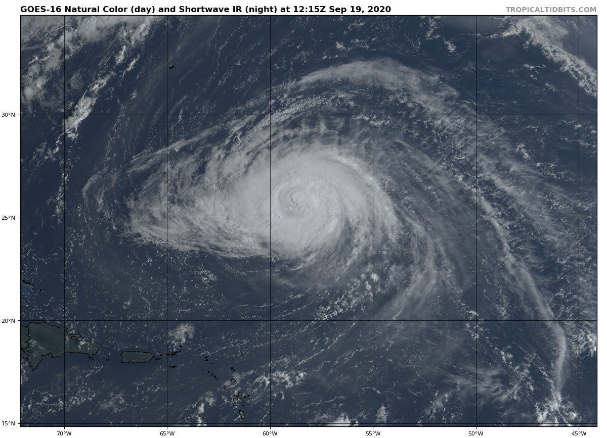
LOCATION…25.5N 58.5W
ABOUT 605 MI…975 KM SE OF BERMUDA
MAXIMUM SUSTAINED WINDS…125 MPH…205 KM/H
PRESENT MOVEMENT…NW OR 325 DEGREES AT 14 MPH…22 KM/H
MINIMUM CENTRAL PRESSURE…952 MB…28.12 INCHES
WATCHES AND WARNINGS
——————–
A Tropical Storm Warning is in effect for…
* Bermuda
DISCUSSION AND OUTLOOK
———————-
At 800 AM AST (1200 UTC), the center of Hurricane Teddy was located near latitude 25.5 North, longitude 58.5 West. Teddy is moving toward the northwest near 14 mph (22 km/h), and this general motion is expected to continue today. A turn toward the north is likely on Sunday, followed by a continued northward motion into early next week. On the forecast track, Teddy will approach Bermuda on Sunday and move near or east of the island late Sunday and early Monday.
Maximum sustained winds are near 125 mph (205 km/h) with higher gusts. Some fluctuations in intensity are likely today. A more pronounced decrease in Teddy’s maximum winds is forecast to begin on Sunday, but the wind field of the hurricane is forecast to increase substantially at the same time.
Hurricane-force winds currently extend outward up to 60 miles (95 km) from the center and tropical-storm-force winds extend outward up to 230 miles (370 km).
The estimated minimum central pressure is 952 MB (28.12 inches).
HAZARDS AFFECTING LAND
———————-
Key messages for Teddy can be found in the Tropical Cyclone Discussion under AWIPS header MIATCDAT5 and WMO header WTNT45 KNHC and on the web at www.hurricanes.gov/text/MIATCDAT5.shtml.
WIND: Tropical storm conditions are expected to affect Bermuda and beginning Sunday afternoon or evening. These conditions may linger through most of the day Monday.
SURF: Large swells generated by Teddy are affecting the Lesser Antilles, the Greater Antilles, the Bahamas, and Bermuda. Swells from Teddy will begin affecting most of the east coast of the United States later today and will reach Atlantic Canada by early Sunday. These swells are likely to cause life-threatening surf and rip current conditions. Please consult products from your local weather office.
Category: ALL POSTS, Severe Weather, Tropical
About the Author (Author Profile)
Scott Martin is an operational meteorologist, professional graphic artist, musician, husband, and father. Not only is Scott a member of the National Weather Association, but he is also the Central Alabama Chapter of the NWA president. Scott is also the co-founder of Racecast Weather, which provides forecasts for many racing series across the USA. He also supplies forecasts for the BassMaster Elite Series events including the BassMaster Classic.Subscribe
If you enjoyed this article, subscribe to receive more just like it.


