Rain in the Extreme Southeastern Parts of Central Alabama Just Past Midday
UPDATE ON CENTRAL ALABAMA’S WEATHER
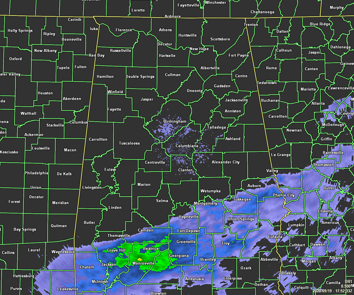
As of 12:52 pm, we have rain currently falling mainly along and south of a line from Hayneville (Lowndes Co.) to Montgomery to roughly Auburn. North of that, skies are generally cloudy but conditions remain dry. Temperatures as of the 12:00 pm roundup were in the upper 60s to the mid-70s across the area. Birmingham, Troy, and Tuscaloosa were the warm spots at 75 degrees. Haleyville was the cool spot at 68 degrees.
Those showers in the extreme southern and southeastern parts of the area may not move farther north during the afternoon and into the early evening hours, staying south of a line from Demopolis to Clanton to Alexander City. Nearly all of the rest of Central Alabama should stay dry, but we can’t rule out a stray isolated shower or two. Skies will remain generally cloudy and highs will top out in the lower to mid-70s across the area. Once we start losing the daylight, shower chances will begin to drop throughout the entire area and we’ll all be dry by the late local news. Skies will be mostly cloudy and lows will be in the upper 50s to the lower 60s.
UPDATE ON THE TROPICS (10:00 am)
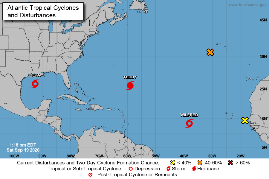
(Yellow X) A tropical wave is located near the west coast of Africa and will move westward over the far eastern Atlantic during the next few days. Development of this system is no longer expected.
* Formation chance through 48 hours…low…near 0 percent.
* Formation chance through 5 days…low…near 0 percent.
(Orange X) Shower activity has increased a little today in association with Post-Tropical Cyclone Paulette, which is moving southward a few hundred miles southwest of the Azores. The cyclone is forecast to continue southward for the next day or so and then stall over marginally warm waters a few hundred miles south of the Azores. The cyclone could subsequently develop tropical or subtropical characteristics by early next week while it moves little. For more information about marine hazards associated with this system, see High Seas Forecasts issued by Meteo France.
* Formation chance through 48 hours…medium…50 percent.
* Formation chance through 5 days…medium…60 percent.
Wilfred: At 1100 AM AST (1500 UTC), the center of Tropical Storm Wilfred was located near latitude 13.4 North, longitude 38.1 West, or about 960 miles west of the Cabo Verde Islands. Wilfred is moving toward the west-northwest near 14 mph, and this general motion is expected to continue for the next few days. Maximum sustained winds are near 40 mph with higher gusts. Little change in intensity is expected for the next day or so, followed by gradual weakening on Monday. Wilfred is expected to become a remnant low by Monday night and dissipate on Tuesday. No threat to land.
Teddy: At 1100 AM AST (1500 UTC), the center of Hurricane Teddy was located near latitude 26.0 North, longitude 59.0 West, or about 560 miles to the southeast of Bermuda. Teddy is moving toward the northwest near 14 mph and this general motion is expected to continue through tonight. A turn toward the north or north-northeast is expected on Sunday, followed by a northward motion into early next week. On the forecast track, Teddy will approach Bermuda on Sunday and the center will pass just east of the island late Sunday and early Monday. Maximum sustained winds are near 120 mph with higher gusts. Teddy is a category 3 hurricane on the Saffir-Simpson Hurricane Wind Scale. Some slow weakening is expected over the next couple of days. A more pronounced decrease in Teddy’s maximum winds is forecast to begin early next week. The wind field of the hurricane is forecast to increase substantially starting on Sunday night. Tropical storm conditions will start occurring late on Sunday. Tropical storm warnings are up for the entire island of Bermuda.
Beta: At 1000 AM CDT (1500 UTC), the center of Tropical Storm Beta was located near latitude 26.6 North, longitude 92.6 West, or about 305 miles east-southeast of Corpus Christi, Texas. Beta is moving toward the northwest near 3 mph. A slow westward motion is expected to begin later today, with a slow northwestward motion forecast to begin late Sunday or Sunday night and continue through late Monday. On the forecast track, the center of Beta will slowly approach the Texas coast into early next week. Maximum sustained winds are near 60 mph with higher gusts. Little change in strength is expected today. After that, slow strengthening is forecast, and Beta is expected to be at or near hurricane strength Sunday night or Monday.
Storm surge and hurricane watches and tropical storm warnings are up for portions of the Texas & Louisiana Gulf Coasts. Storm surge of 1-4 feet will be possible in the watch area. Rough surf and dangerous rip currents are expected to increase today and persist through much of next week. Rainfall of 3-5 inches can be expected with isolated totals approaching 10 inches will be possible. Tropical storm conditions are expected in the tropical storm Warning area by late Sunday or Sunday night. Hurricane conditions are possible within the hurricane watch area by late Monday or Monday night.
Category: Alabama's Weather, ALL POSTS, Tropical
About the Author (Author Profile)
Scott Martin is an operational meteorologist, professional graphic artist, musician, husband, and father. Not only is Scott a member of the National Weather Association, but he is also the Central Alabama Chapter of the NWA president. Scott is also the co-founder of Racecast Weather, which provides forecasts for many racing series across the USA. He also supplies forecasts for the BassMaster Elite Series events including the BassMaster Classic.Subscribe
If you enjoyed this article, subscribe to receive more just like it.


