1:00 PM Updates Are Out on Beta and Teddy… No Drastic Changes with Either System
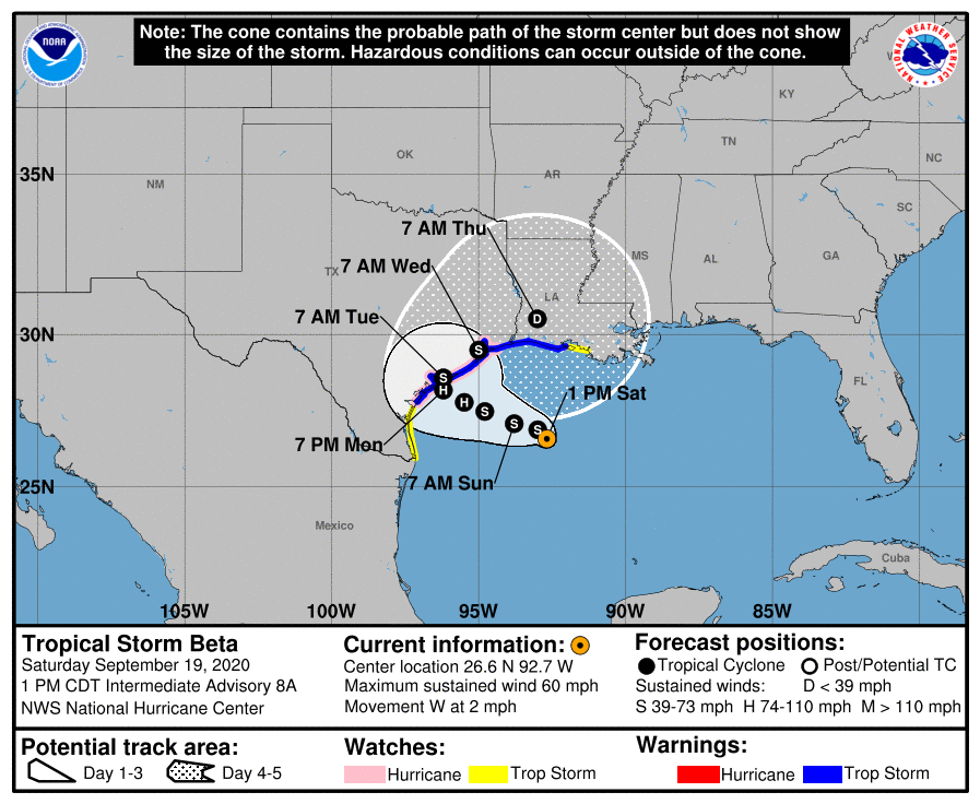
At 100 PM CDT (1800 UTC), the center of Tropical Storm Beta was located near latitude 26.6 North, longitude 92.7 West, or about 305 miles east-southeast of Corpus Christi, Texas. Beta is moving toward the west near 2 mph, and a slow-motion toward the west should continue into Sunday. A slow northwestward motion is forecast to begin late Sunday or Sunday night and continue through late Monday. On the forecast track, the center of Beta will slowly approach the Texas coast into early next week. Maximum sustained winds are near 60 mph with higher gusts. Little change in strength is expected today. After that, slow strengthening is forecast, and Beta is expected to be at or near hurricane strength Sunday night or Monday. Landfall may occur on the Texas coast near Palacios early on Tuesday morning as a strong tropical storm or a minimal hurricane.
The expected slow motion of Beta has the potential to produce a long duration rainfall event along the western Gulf Coast. The potentially prolonged period of rainfall could cause flash, urban, and river flooding, especially where tide levels are above normal. Life-threatening storm surge and hurricane-force winds are possible along portions of the northwestern Gulf Coast, with tropical storm conditions expected by late this weekend. Storm Surge and Hurricane watches and Tropical Storm warnings are in effect, and residents in these areas should ensure they have their hurricane plan in place and follow the advice given by local officials.
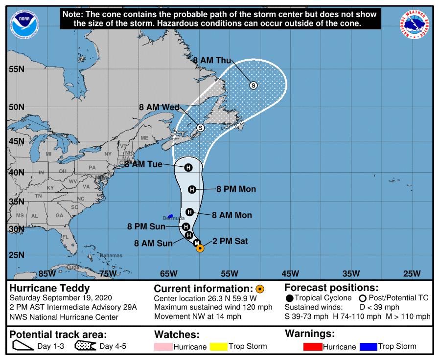
At 200 PM AST (1800 UTC), the center of Hurricane Teddy was located near latitude 26.3 North, longitude 59.9 West, or about 515 miles southeast of Bermuda. Teddy is moving toward the northwest near 14 mph and this general motion is expected to continue through tonight. A turn toward the north or north-northeast is expected on Sunday, followed by a northward motion into early next week. On the forecast track, Teddy will approach Bermuda on Sunday and the center will pass just east of the island late Sunday and early Monday. Maximum sustained winds are near 120 mph with higher gusts. Teddy is a category 3 hurricane on the Saffir-Simpson Hurricane Wind Scale. Some slow weakening is expected over the next couple of days. A more pronounced decrease in Teddy’s maximum winds is forecast to begin early next week. The wind field of the hurricane is forecast to increase substantially starting on Sunday night.
While the center of Teddy is forecast to move east of Bermuda late Sunday or Monday, tropical storm conditions are likely on the island beginning Sunday afternoon or evening. Teddy is expected to transition to a powerful post-tropical cyclone as it moves near or over portions of Atlantic Canada early next week, where there is an increasing risk of direct impacts from wind, rain, and storm surge. Residents there should closely monitor the progress of Teddy and updates to the forecast. Large swells produced by Teddy are expected to affect portions of the Leeward Islands, the Greater Antilles, the Bahamas, Bermuda, the east coast of the United States, and Atlantic Canada during the next few days. These swells could cause life-threatening surf and rip current conditions.
Category: ALL POSTS, Severe Weather, Tropical
About the Author (Author Profile)
Scott Martin is an operational meteorologist, professional graphic artist, musician, husband, and father. Not only is Scott a member of the National Weather Association, but he is also the Central Alabama Chapter of the NWA president. Scott is also the co-founder of Racecast Weather, which provides forecasts for many racing series across the USA. He also supplies forecasts for the BassMaster Elite Series events including the BassMaster Classic.Subscribe
If you enjoyed this article, subscribe to receive more just like it.


