

Beta Drenching the Central Texas Coast with Heavy Rains & Tropical-Storm-Force Winds
BULLETIN
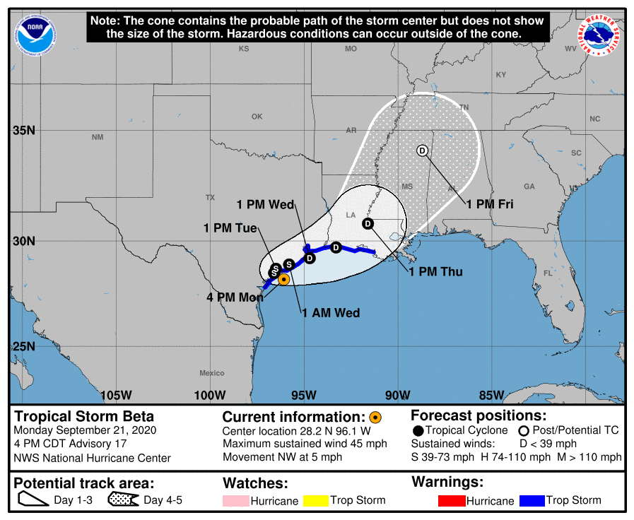
Tropical Storm Beta Advisory Number 17
NWS National Hurricane Center Miami FL AL222020
400 PM CDT Mon Sep 21 2020
…SLOW-MOVING BETA GETTING CLOSER TO THE TEXAS COAST…
…TROPICAL-STORM-FORCE WIND GUSTS AND HEAVY RAINS OCCURRING OVER THE CENTRAL TEXAS COASTAL AREA…
SUMMARY OF 400 PM CDT…2100 UTC…INFORMATION
———————————————-
LOCATION…28.2N 96.1W
ABOUT 25 MI…35 KM SE OF PORT OCONNOR TEXAS
ABOUT 30 MI…45 KM SSW OF MATAGORDA TEXAS
MAXIMUM SUSTAINED WINDS…45 MPH…75 KM/H
PRESENT MOVEMENT…NW OR 310 DEGREES AT 5 MPH…7 KM/H
MINIMUM CENTRAL PRESSURE…999 MB…29.50 INCHES
WATCHES AND WARNINGS
——————–
A Storm Surge Warning is in effect for…
* Port Aransas, Texas to Sabine Pass, Texas including Copano Bay, Aransas Bay, San Antonio Bay, Matagorda Bay, and Galveston Bay.
A Tropical Storm Warning is in effect for…
* Port Aransas Texas to Morgan City Louisiana
DISCUSSION AND OUTLOOK
———————-
At 400 PM CDT (2100 UTC), the center of Tropical Storm Beta was located by NOAA Doppler weather radars and surface observations near latitude 28.2 North, longitude 96.1 West. Beta is moving toward the northwest near 5 mph (7 km/h), and this general motion is forecast to continue today. A decrease in forward speed and a sharp turn to the north and northeast are expected on Tuesday. On the forecast track, the center of Beta will continue to move toward the central coast of Texas today and will likely move inland by tonight. Beta is forecast to remain near or just offshore the coast of southeastern Texas on Tuesday and Wednesday.
Maximum sustained winds are near 45 mph (75 km/h) with higher gusts. Little change in strength is forecast before Beta reaches the Texas coast. Weakening is anticipated once Beta moves inland.
Tropical-storm-force winds extend outward up to 175 miles (280 km) from the center. A Texas TCOON observing site at Port O’Connor, Texas, has recently measured a wind gust to 43 mph (69 km/h).
The estimated minimum central pressure is 999 MB (29.50 inches).
HAZARDS AFFECTING LAND
———————-
STORM SURGE: The combination of a dangerous storm surge and the tide will cause normally dry areas near the coast to be flooded by rising waters moving inland from the shoreline. The water could reach the following heights above ground somewhere in the indicated areas if the peak surge occurs at the time of high tide…
* Port Aransas, TX to Sabine Pass, TX including Copano Bay, Aransas Bay, San Antonio Bay, Matagorda Bay, and Galveston Bay…2-4 ft
* Sabine Pass, TX to Ocean Springs, MS including Sabine Lake, Lake Calcasieu, Vermilion Bay, Lake Borgne, Lake Pontchartrain, and Lake Maurepas…1-3 ft
* Baffin Bay, TX to Port Aransas, TX including Corpus Christi Bay and Baffin Bay… 1-3 ft
* The mouth of the Rio Grande to Baffin Bay, TX…1-2 ft
The deepest water will occur along the immediate coast in areas of onshore winds, where the surge will be accompanied by large and dangerous waves. Surge-related flooding depends on the relative timing of the surge and the tidal cycle and can vary greatly over short distances. For information specific to your area, please see products issued by your local National Weather Service forecast office.
WIND: Tropical storm conditions are expected to begin later this evening in portions of the tropical storm warning area. Tropical storm conditions are possible within the tropical storm watch area later today.
RAINFALL: Through Friday, Beta is expected to produce rainfall accumulations of 5 to 10 inches with isolated totals of 15 inches from the middle Texas coast to southeast Louisiana. Rainfall totals of 3 to 5 inches are expected northward into the ArkLaTex region and east into the Lower Mississippi Valley through the end of the week. Flash and urban flooding are likely, as well as isolated minor river flooding.
TORNADOES: A tornado or two could occur through Tuesday near the middle to upper Texas coast or the southwestern Louisiana coast.
SURF: Swells generated by a combination of Beta and a cold front over the northern Gulf of Mexico will continue along the coasts of Louisiana and Texas during the next couple of days. These swells are likely to cause life-threatening surf and rip current conditions. Please consult products from your local weather office.
Category: ALL POSTS, Partner News Stories
About the Author (Author Profile)
Scott Martin is an operational meteorologist, professional graphic artist, musician, husband, and father. Not only is Scott a member of the National Weather Association, but he is also the Central Alabama Chapter of the NWA president. Scott is also the co-founder of Racecast Weather, which provides forecasts for many racing series across the USA. He also supplies forecasts for the BassMaster Elite Series events including the BassMaster Classic.Subscribe
If you enjoyed this article, subscribe to receive more just like it.


