Teddy Expected to Expand & Intensify North of Bermuda
BULLETIN
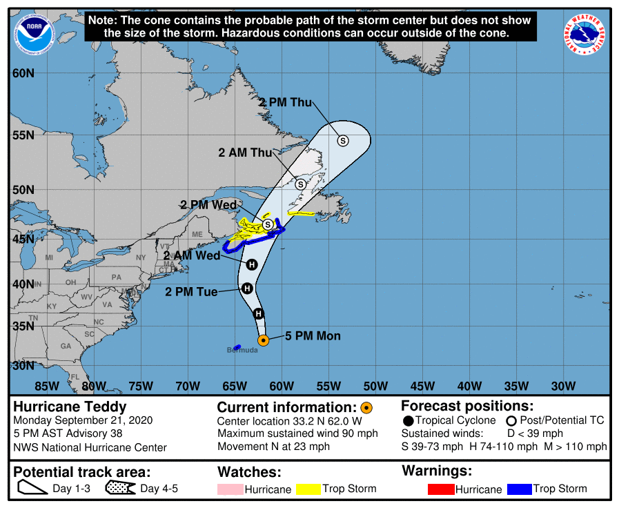
Hurricane Teddy Advisory Number 38
NWS National Hurricane Center Miami FL AL202020
500 PM AST Mon Sep 21 2020
…TEDDY ABOUT TO GET LARGER AND STRONGER NORTH OF BERMUDA…
…LIFE-THREATENING RIP CURRENTS EXPECTED ALONG WESTERN ATLANTIC BEACHES FOR A FEW MORE DAYS…
SUMMARY OF 500 PM AST…2100 UTC…INFORMATION
———————————————-
LOCATION…33.2N 62.0W
ABOUT 175 MI…280 KM ENE OF BERMUDA
ABOUT 790 MI…1275 KM S OF HALIFAX NOVA SCOTIA
MAXIMUM SUSTAINED WINDS…90 MPH…150 KM/H
PRESENT MOVEMENT…N OR 0 DEGREES AT 23 MPH…37 KM/H
MINIMUM CENTRAL PRESSURE…958 MB…28.29 INCHES
WATCHES AND WARNINGS
——————–
A Tropical Storm Warning is in effect for…
* South coast of Nova Scotia from Digby to Meat Cove
A Tropical Storm Watch is in effect for…
* Meat Cove to Tidnish
* North of Digby to Fort Lawrence
* Magdalen Islands
* Port aux Basques to Francois Newfoundland
DISCUSSION AND OUTLOOK
———————-
At 500 PM AST (2100 UTC), the center of Hurricane Teddy was located near latitude 33.2 North, longitude 62.0 West. Teddy is moving toward the north near 23 mph (37 km/h), and this motion is expected tonight followed by a turn to the north-northwest on Tuesday. Teddy should turn to the north-northeast and move over eastern Nova Scotia on Wednesday then over the Gulf of St. Lawrence late Wednesday into Thursday.
Maximum sustained winds are near 90 mph (150 km/h) with higher gusts. Teddy is expected to gain strength overnight, but weaken steadily by Wednesday and become a strong post-tropical cyclone before reaching Nova Scotia.
Teddy is a large hurricane. Hurricane-force winds extend outward up to 80 miles (130 km) from the center and tropical-storm-force winds extend outward up to 275 miles (445 km).
The estimated minimum central pressure is 958 MB (28.29 inches).
HAZARDS AFFECTING LAND
———————-
WIND: Tropical storm conditions are expected to begin in the warning area by Tuesday afternoon. Tropical-storm-conditions could begin in the watch areas late Tuesday or early Wednesday.
SURF: Large swells generated by Teddy are affecting Bermuda, the Lesser Antilles, the Greater Antilles, the Bahamas, the east coast of the United States, and Atlantic Canada. These swells are likely to cause life-threatening surf and rip current conditions. Please consult products from your local weather office.
RAINFALL: From Tuesday through Thursday, Teddy is expected to produce rainfall accumulations of 2 to 4 inches (50 to 100 mm) with isolated totals of 6 inches (150 mm) across sections of Atlantic Canada.
STORM SURGE: A dangerous storm surge is expected to produce significant coastal flooding near and to the east of where the center makes landfall in Nova Scotia. Near the coast, the surge will be accompanied by very large and destructive waves.
Category: ALL POSTS, Severe Weather, Tropical
About the Author (Author Profile)
Scott Martin is an operational meteorologist, professional graphic artist, musician, husband, and father. Not only is Scott a member of the National Weather Association, but he is also the Central Alabama Chapter of the NWA president. Scott is also the co-founder of Racecast Weather, which provides forecasts for many racing series across the USA. He also supplies forecasts for the BassMaster Elite Series events including the BassMaster Classic.Subscribe
If you enjoyed this article, subscribe to receive more just like it.


