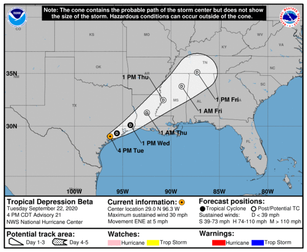
Beta Continues to Bring Heavy Rains & Flooding to the Upper Texas Coast
BULLETIN
Tropical Depression Beta Advisory Number 21
NWS National Hurricane Center Miami FL AL222020
400 PM CDT Tue Sep 22 2020
…SLOW-MOVING BETA PRODUCING HEAVY RAINFALL AND FLOODING OVER PORTIONS OF THE UPPER TEXAS COAST…
…THIS IS THE LAST ADVISORY ISSUED BY THE NATIONAL HURRICANE CENTER…
SUMMARY OF 400 PM CDT…2100 UTC…INFORMATION
———————————————-
LOCATION…29.0N 96.3W
ABOUT 40 MI…65 KM N OF PORT OCONNOR TEXAS
ABOUT 35 MI…55 KM NNW OF MATAGORDA TEXAS
MAXIMUM SUSTAINED WINDS…30 MPH…45 KM/H
PRESENT MOVEMENT…ENE OR 65 DEGREES AT 5 MPH…7 KM/H
MINIMUM CENTRAL PRESSURE…1008 MB…29.77 INCHES
WATCHES AND WARNINGS
——————–
There are no coastal watches or warnings in effect.
DISCUSSION AND OUTLOOK
———————-
At 400 PM CDT (2100 UTC), the center of Tropical Depression Beta was located by surface observations, satellites, and NOAA Doppler weather radars near latitude 29.0 North, longitude 96.3 West. The depression is moving toward the east-northeast near 5 mph (7 km/h) and this general motion is expected to continue through Friday. On the forecast track, the center of Beta will move inland over southeastern Texas through Wednesday and then over Louisiana and Mississippi Wednesday night through Friday.
Data from surface observations and NOAA Doppler weather radars indicate that maximum sustained winds have decreased to near 30 mph (45 km/h) with higher gusts. Gradual weakening is forecast through Friday, and Beta is expected to become a remnant low-pressure system by late Wednesday.
The estimated minimum central pressure based on nearby surface observations is 1008 MB (29.77 inches).
HAZARDS AFFECTING LAND
———————-
RAINFALL: For the middle and upper Texas coast, additional rainfall of 4 to 8 inches with isolated storm totals up to 20 inches is expected. Significant flash and urban flooding is occurring and will continue today. Minor to isolated moderate river flooding is likely.
Rainfall totals of 13 to 14 inches have been measured across portions of the Houston metropolitan area thus far.
Rainfall totals of 2 to 5 inches are expected east into the Lower Mississippi Valley and portions of the Tennessee Valley through the end of the week. Flash and urban flooding are possible, as well as isolated minor river flooding on smaller rivers.
TORNADOES: A tornado or two cannot be ruled out this evening along the upper Texas and southwestern Louisiana coasts.
SURF: Swells generated by a combination of Beta and a cold front over the northern Gulf of Mexico will continue along the coasts of Louisiana and Texas during the next couple of days. These swells are likely to cause life-threatening surf and rip current conditions.
This is the last NHC advisory on Beta. Future information on this system, including the rainfall threat, can be found in Public Advisories issued by the Weather Prediction Center beginning at 10 PM CDT, under AWIPS header TCPAT2, WMO header WTNT32 KWNH, and on the web at http://www.wpc.ncep.noaa.gov
Category: ALL POSTS, Severe Weather, Tropical


