Teddy Is Ginormous, Paulette Is On Her Way Out… Again, & Another Area to Watch
GINORMOUS TEDDY TO BRING DESTRUCTIVE WAVES, HEAVY RAIN, AND STRONG WINDS TO PORTIONS OF NOVA SCOTIA TODAY THROUGH WEDNESDAY
TROPICAL STORM WARNING ISSUED FOR PARTS OF NEWFOUNDLAND
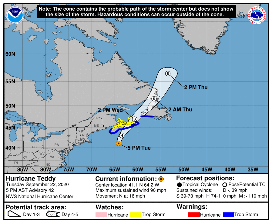
At 500 PM AST (2100 UTC), the center of Hurricane Teddy was located near latitude 41.1 North, longitude 64.2 West. Teddy is moving toward the north near 16 mph (26 km/h), and a turn toward the north-northeast is expected by early Wednesday. On the forecast track, the center will move over eastern Nova Scotia on Wednesday, and then near or over Newfoundland by Wednesday night, and be east of Labrador on Thursday. Maximum sustained winds are near 90 mph (150 km/h) with higher gusts. Although some weakening is likely tonight and Wednesday, Teddy should be a strong post-tropical cyclone when it moves near and over Nova Scotia.
Teddy is an extremely large hurricane. Hurricane-force winds extend outward up to 125 miles (205 km) from the center and tropical-storm-force winds extend outward up to 540 miles (870 km). Buoy 44150, located about 90 n mi north of the center, recently reported a significant wave height of 42 ft (13 m). The estimated minimum central pressure is 958 MB (28.29 inches).
Tropical Storm Watches and Warnings are in effect for portions of Nova Scotia, Newfoundland, Prince Edward Island, and the Magdalen Islands, and heavy rainfall across Atlantic Canada is expected through Thursday.
Teddy is expected to transition to a powerful post-tropical cyclone as it moves near or over portions of Atlantic Canada late today through Thursday. The most significant hazard expected from Teddy is large destructive waves forecast along the southern coast of Nova Scotia through Wednesday. Very large swells produced by Teddy are expected to affect portions of Bermuda, the Leeward Islands, the Greater Antilles, the Bahamas, the east coast of the United States, and Atlantic Canada during the next few days. These swells are expected to cause life-threatening surf and rip current conditions.
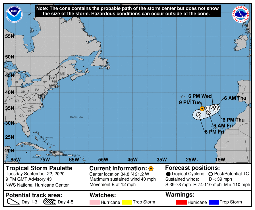
PAULETTE EXPECTED TO BECOME POST-TROPICAL LATER TONIGHT OR WEDNESDAY MORNING– AGAIN
At 900 PM GMT (2100 UTC), the center of Tropical Storm Paulette was located near latitude 34.8 North, longitude 21.2 West. Paulette is moving toward the east near 12 mph (19 km/h). An eastward to east-northeastward motion is forecast through Wednesday. A decrease in the forward motion along with turns to the southeast then south is expected Wednesday night through Thursday. A southwestward motion is forecast to begin by late this week. Maximum sustained winds are near 40 mph (65 km/h) with higher gusts. Slow weakening is forecast, and Paulette is expected to become a remnant low by Wednesday morning.
Showers and thunderstorms extending from the southeastern Bahamas westward through Cuba and into the southeastern Gulf of Mexico are associated with a cold front. This system is forecast to move little for the next day or so, then move back northward on Thursday through Saturday. While the development of this system over the southeastern Gulf of Mexico late this week is very unlikely, locally heavy rainfall is possible over portions of Cuba through Wednesday and over the Florida Keys and south Florida on Thursday and Friday.
* Formation chance through 48 hours…low…near 0 percent.
* Formation chance through 5 days…low…10 percent.
Category: ALL POSTS, Severe Weather, Tropical
About the Author (Author Profile)
Scott Martin is an operational meteorologist, professional graphic artist, musician, husband, and father. Not only is Scott a member of the National Weather Association, but he is also the Central Alabama Chapter of the NWA president. Scott is also the co-founder of Racecast Weather, which provides forecasts for many racing series across the USA. He also supplies forecasts for the BassMaster Elite Series events including the BassMaster Classic.Subscribe
If you enjoyed this article, subscribe to receive more just like it.


