Tropical Storm Gamma Is Named
Based on Air Force Reconnaissance reports, Tropical Depression 25 has become Tropical Gamma.
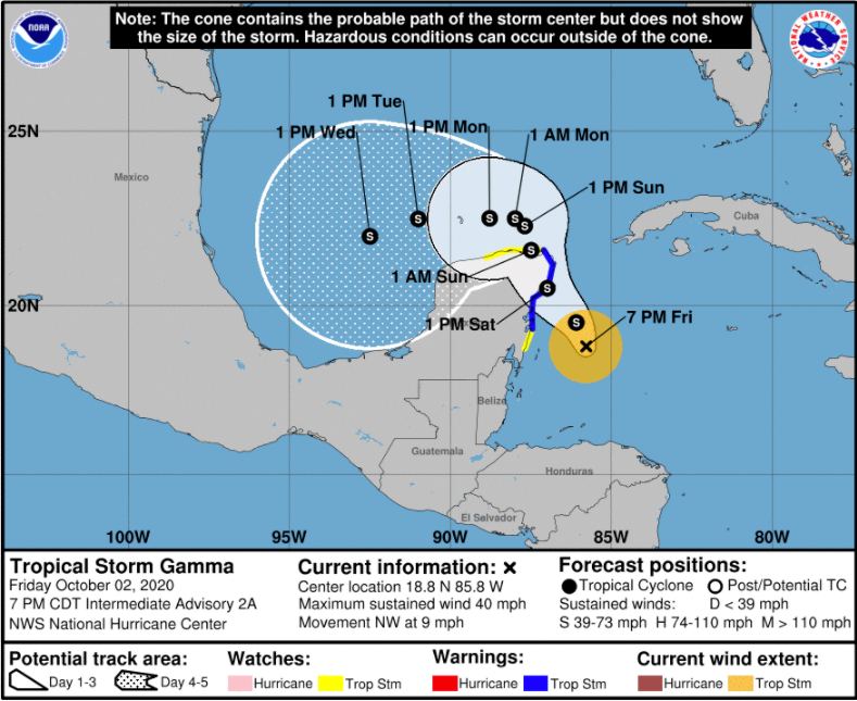
The system is moving northwest and the center will reach the northeastern Yucatan Peninsula tomorrow afternoon as a 45 mph tropical storm.
It should move into the southern Gulf of Mexico late Sunday night and turn west and eventually southwest.
We are keeping our eye on a second system south of the Dominican Republican that is also expected to become a tropical depression or tropical storm in the western Caribbean by Monday. This system looks likely to move into the Gulf of Mexico as well. There are signs that it could move slowly toward the northern Gulf Coast over the next week as a weakening system, perhaps a depression.
BULLETIN
Tropical Storm Gamma Intermediate Advisory Number 2A
NWS National Hurricane Center Miami FL AL252020
700 PM CDT Fri Oct 02 2020
…DEPRESSION BECOMES TROPICAL STORM GAMMA OVER THE NORTHWESTERN
CARIBBEAN SEA…
SUMMARY OF 700 PM CDT…0000 UTC…INFORMATION
———————————————-
LOCATION…18.8N 85.8W
ABOUT 135 MI…220 KM SSE OF COZUMEL MEXICO
MAXIMUM SUSTAINED WINDS…40 MPH…65 KM/H
PRESENT MOVEMENT…NW OR 315 DEGREES AT 9 MPH…15 KM/H
MINIMUM CENTRAL PRESSURE…1000 MB…29.53 INCHES
WATCHES AND WARNINGS
——————–
CHANGES WITH THIS ADVISORY:
None.
SUMMARY OF WATCHES AND WARNINGS IN EFFECT:
A Tropical Storm Warning is in effect for…
* Punta Herrero to Cabo Catoche Mexico
A Tropical Storm Watch is in effect for…
* South of Punta Herrero to Puerto Costa Maya Mexico
* West of Cabo Catoche to Dzilam Mexico
A Tropical Storm Warning means that tropical storm conditions are
expected somewhere within the warning area within 36 hours.
A Tropical Storm Watch means that tropical storm conditions are
possible within the watch area, generally within 48 hours.
For storm information specific to your area, please monitor
products issued by your national meteorological service.
DISCUSSION AND OUTLOOK
———————-
At 700 PM CDT (0000 UTC), the center of Tropical Storm Gamma was
located near latitude 18.8 North, longitude 85.8 West. Gamma is
moving toward the northwest near 9 mph (15 km/h), and a gradual turn
toward the north-northwest with a decrease in forward speed is
expected over the next couple of days. On the forecast track, the
center of the tropical cyclone should be near the northeastern
Yucatan Peninsula on Saturday.
Maximum sustained winds are near 40 mph (65 km/h) with higher
gusts. Slow strengthening is forecast during the next few days.
The estimated minimum central pressure based on data from the Air
Force Hurricane Hunters is 1000 mb (29.53 inches).
HAZARDS AFFECTING LAND
———————-
Key messages for Tropical Storm Gamma can be found in the Tropical
Cyclone Discussion under AWIPS header MIATCDAT5, WMO header WTNT45
KNHC, and on the web at www.hurricanes.gov/text/MIATCDAT5.shtml.
RAINFALL: Gamma is expected to produce rainfall of 4 to 8
inches with isolated maximum amounts of 12 inches in portions of the
Yucatan Peninsula and far western Cuba. A separate area of
significant rain is expected to develop well away from the center in
the Mexican states of Campeche, Tabasco, and northern Chiapas with
rainfall of 8 to 12 inches and isolated maximum amounts of 20
inches. This rainfall may produce life-threatening flash floods and
mudslides.
Rainfall of 1 to 3 inches with maximum amounts of 5 inches is
expected in the Bay Islands of Honduras and over the Cayman Islands.
WIND: Tropical storm conditions are expected within the Tropical
Storm Warning area by Saturday morning, and are possible within the
Tropical Storm Watch area on Saturday and Sunday.
NEXT ADVISORY
————-
Next complete advisory at 1000 PM CDT.
$$
Forecaster Cangialosi
About the Author (Author Profile)
Bill Murray is the President of The Weather Factory. He is the site's official weather historian and a weekend forecaster. He also anchors the site's severe weather coverage. Bill Murray is the proud holder of National Weather Association Digital Seal #0001 @wxhistorianSubscribe
If you enjoyed this article, subscribe to receive more just like it.


