

Weather Xtreme: Another Beautiful Sunday
On this date in 1994, a worst-case scenario was facing weather forecasters as Hurricane Opal went from a category 2 hurricane with top winds of 100 mph at noon on October 3rd as the O.J. Simpson verdict was being read, to a 150 mph category 5 monster with a central pressure of 916 millibars by 5 a.m. on the 4th. The storm had rapidly intensified that morning, dropping from 951 to 916 millibars in just 9 hours. At the time, Opal was 250 nautical miles south-southwest of Pensacola, Florida. Not only had the storm’s winds increased, but so had its forward speed, and preparations were frantic. Fortunately, Opal could not maintain peak intensity as the inner eyewall collapsed within a few hours. The maximum sustained winds were 115 mph near the center of the storm at landfall just east of Pensacola on the evening of the 4th. Although winds were diminishing at the time of landfall, extensive damage due to a storm surge of 15 feet and breaking waves occurred over most of the coastal areas of the Florida panhandle. Massive power outages were recorded well into Alabama as the storm moved quickly through the state during the night.
FORTUNATELY NOTHING LIKE THAT TODAY: Another beautiful morning is in progress across North and Central Alabama. With partly cloudy skies, temperatures are in the 40s across the northern half of the state, with lower 50s over South Central Alabama. This good looking morning will lead to another nice day across the state, despite the approach of an upper-level trough and cold front. Highs by afternoon will be in the middle 70s in the North, with upper 70s over the rest of Central Alabama. The front should reach I-59 by sunset, but you won’t notice any real difference in weather on the other side of it, just a few wind gusts overnight. Lows by Monday morning will be in the upper 40s North and lower 50s across Central Alabama.
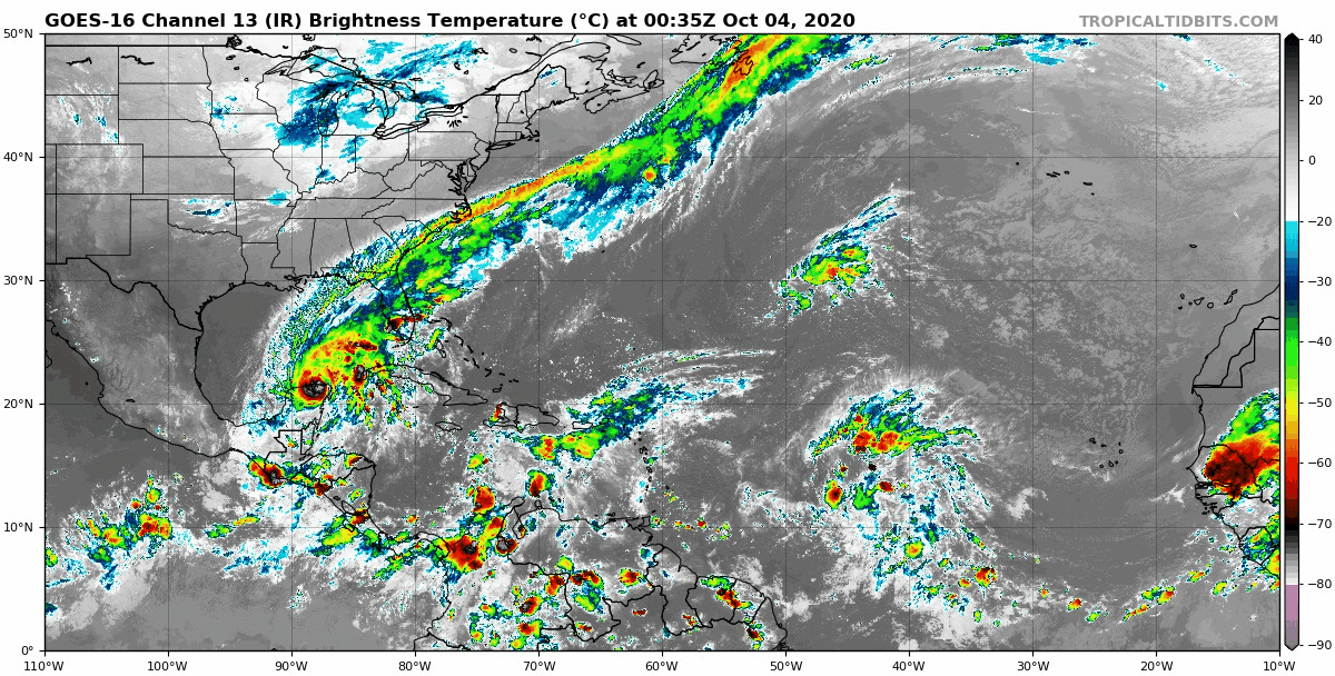
EYE ON THE TROPICS: Tropical Storm Gamma nearly reached hurricane status yesterday before making landfall over the northeastern Yucatan peninsula Saturday. The storm will emerge into the southern Gulf of Mexico today and turn to the west as high pressure develops to the north of the system. The tropical storm will make a slow journey just offshore of the northern coast of the Yucatan over the next couple of days, moving into the southwestern Gulf, or Bay of Campeche. There are some indications that the system will not amount to much in the future, and may even dissipate, as it encounters fairly strong shear.
WATCHING 92L: A tropical wave entering the western Caribbean is the next system to watch. It will become a tropical depression or tropical storm over the next couple of days as it moves toward the Gulf of Mexico. It appears that conditions will remain favorable for intensification as it enters the Gulf and it should become a hurricane. Beyond that, we don’t have a good handle on where it will go eventually or how strong it might be. There is a tremendous spread in the models’ solutions on both. Some don’t turn it into much. Some carry it toward the northern Gulf Coast, perhaps toward the eastern Florida Panhandle, or the Florida Big Bend. Some also move it toward the Mobile and Pensacola areas. It is just too early to make any predictions about eventual track or intensity.
OUR FORECAST: My forecast this morning will be based on the GFS, which is more aggressive with Gulf moisture getting up into Alabama this week. There is quite a bit of uncertainty involved in that happening, and the recent forecasts of dry conditions all week may end up prevailing, but I think the GFS may be right here, so I will go with its premise.
MONDAY: A large ridge of high pressure will cover much of the eastern United States. This will be what is steering Gamma slowly westward in the southern Gulf. Alabama will be high and dry with mostly sunny skies and mild high temperatures in the lower 70s over the North, middle and upper 70s over Central Alabama, with readings with 80F over South Central Alabama.
WARMING THROUGH MIDWEEK: The upper-level ridge across much of the U.S. will actually increase in amplitude as we go through the week. The resulting higher pressure will allow temperatures to climb into the lower 80s Tuesday, and middle 80s Wednesday, and Thursday. Morning lows will be in the 40s North and 50s South Tuesday but will warm into the 50s by Wednesday and Thursday mornings. By Wednesday afternoon, the Gulf system will be in the Central Gulf. Showers will be affecting the Florida Peninsula and moving into the eastern Panhandle, but most of Alabama should be dry. Rain and storms will spread across the Panhandle Wednesday night and into Coastal and South Alabama Thursday morning.
WEEKEND WEATHER: The system should weaken and turn westward on Friday, moving toward the Louisiana coast by early Saturday. Moisture will spread northward across Alabama, covering the southern half of the state Friday night. Rain may overspread Central Alabama Saturday, reaching into North Alabama. Rainfall amounts will not be generous over Central Alabama, between one half and one inch. Much lesser amounts will occur to the north. South Alabama will see around two inches.
VOODOO TERRITORY: High pressure remains in control of much of the nation’s weather toward the end of the period around October 18th-19th. Mostly dry conditions will prevail, with a few passing fronts bringing periods of light showers at times.
BEACHCAST: Beautiful weather is expected along the beaches of Alabama and Northwest Florida through Wednesday. Rain will begin to appear over eastern sections of the Panhandle Wednesday night, spreading across the rest of the Panhandle and into coastal Alabama on Thursday. Showers and storms will continue on Friday and Saturday. Highs will be in the 80s, lows in the 60s all week. Water temperatures are in the lower 70s. Rip currents may eventually become a problem by midweek depending on the intensity of any tropical systems that venture into the Central Gulf.
Click here to see the Beach Forecast Center page.
DANCING WITH THE STATS: Record pace of the North Atlantic Hurricane Season continues with the earliest 24th named storm ever. There have been lots of storms, but several of them have been short-lived. Still, according to Phil Klotzbach, the 2020 season has generated 80 named storm days to this point. Only five years in the satellite era (since 1960) have generated more named storm days through October 3rd: 1995, 2004, 2005, 2012, and 2017.
WEATHERBRAINS: This week, the panel will entertain respected Texas meteorologist Lon Curtis. He will have some great stories to share. Check out the show at www.WeatherBrains.com. You can also subscribe on iTunes. You can watch the show live at live.bigbrainsmedia.com or on James’ YouTube Channel You will be able to see the show on the James Spann 24×7 weather channel on cable or directly over the air on the dot 2 feed.
ON THIS DATE IN 2019: Birmingham recorded its eighth consecutive daily record high with a reading of 98F. Follow my weather history tweets on Twitter. I am @wxhistorian at Twitter.com.
Category: Alabama's Weather, ALL POSTS, Tropical
About the Author (Author Profile)
Bill Murray is the President of The Weather Factory. He is the site's official weather historian and a weekend forecaster. He also anchors the site's severe weather coverage. Bill Murray is the proud holder of National Weather Association Digital Seal #0001 @wxhistorianSubscribe
If you enjoyed this article, subscribe to receive more just like it.


