

A Look at the Tropics: 92L Could Affect U.S. Gulf Coast Late in the Week, Gamma Will Remain South
GAMMA
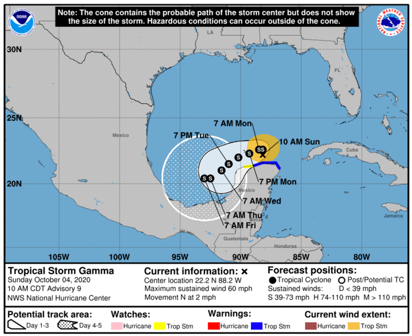
Gamma is over the southern Gulf of Mexico this morning, just north of the Yucatan Peninsula. It has re-strengthened and has top winds of 60 mph. It has slowed its forward progress and it moving north at 2 mph.
It is expected to turn to the west today and will begin a slow westward meandering just off the north coast of the Yucatan for the next couple of days. It will eventually wander into the Bay of Campeche over the southwestern Gulf of Mexico through Friday, weakening as it goes die to unfavorable wind shear conditions. It is not a threat to the United States.

92L
The disturbance over the Central Caribbean continues to become better organized and will become a tropical depression in the next day or so according to the National Hurricane Center. It is expected to move toward the southern Gulf of Mexico by early Tuesday. There is a great deal of spread in the inteni=sity models by then, but it could be anywhere from a strong tropical storm to a category one hurricane. The HMON, one of the hurricane models, even forecasts it to be a category two hurricane by then.
Here are the various intensity models:

There will be a great deal of consternation though when the storm is over the Gulf, because it might even become a major hurricane for a time at midweek before weakening as it draws closer to the coast.
If it does, it appears it will be named Delta, the next name on the list. No other disturbances in the Atlantic pose a threat to be named first.
There is a great deal of uncertainty about the track of course at this point. The GFS ensembles are pointing to a landfall likely on the southern coast of Louisiana between Lake Charles and Grand Isle Friday night as an approximately 980 millibar hurricane, or probably equivalent to a category one or low end two.
This course would bring lots of rain, storms, and windy conditions to Alabama next weekend.
The good news is that sea surface temperatures are cooling now, and it would be running into cooler water as it approached the coast and it should be weakening.
The other global and hurricane models are kind of in line with this thinking this morning. The HMON is an outlier to the east, showing the northeasterly turn a little earlier and bringing the storm more toward the Alabama/Northwest Florida coast. That is one possibility we will have to watch but by no means a forecast.
And you have to remember, we are dealing with a system that is 5-6 days away that hasn’t even formed yet. So any talk now is simply speculation. But it is now a clear possibility that we may deal with a hurricane in the Gulf this week, possibly threatening the northern Gulf Coast, and that bears watching. All residents and interests along the Gulf Coast should pay attention to the latest information and be ready in case preparations are needed.
Category: Alabama's Weather, ALL POSTS, Tropical
About the Author (Author Profile)
Bill Murray is the President of The Weather Factory. He is the site's official weather historian and a weekend forecaster. He also anchors the site's severe weather coverage. Bill Murray is the proud holder of National Weather Association Digital Seal #0001 @wxhistorianSubscribe
If you enjoyed this article, subscribe to receive more just like it.


