Delta Strengthening Again
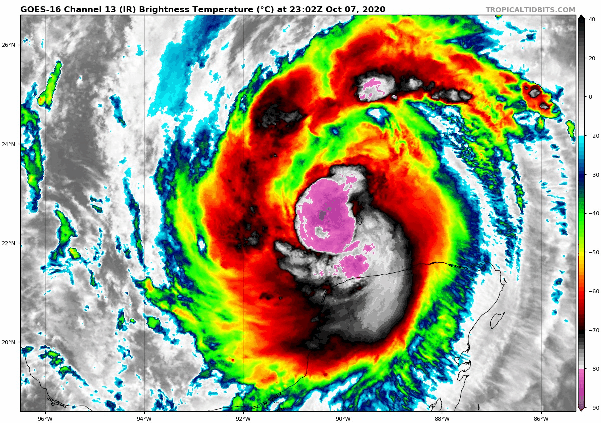
Top winds in Delta are back up to 90 mph as the well-organized storm moves away from the Yucatan Peninsula. It could be a major hurricane again by this time tomorrow.
Convection is increasing around the center. It will continue to move over warm sea surface temperatures. Although the oceanic heat content is not as great as it was in the Caribbean, it is still warm enough to support intensification. Wind shear is light for now and will remain so until Friday morning when it will begin to increase. By Friday afternoon, thee shear will be strong, so that, combined with the cooler water temperatures near the coast will allow for weakening before landfall.
The models are in good agreement that landfall will occur Friday afternoon on the Louisiana coast east of Lake Charles and west of Grand Isle, most likely near or just west of Vermillion Bay.
The forecast cone, which indicates where the center should come inland, extends from Port Arthur, Texas to near Morgan City now, so the New Orleans area, as well as the Missississippi and Alabama coasts, should be safe from a direct landfall. But the impacts from Delta will extend well beyond the cone, with tropical storm force winds extending 160 miles to the east and 125 miles to the west of the center where it lands. Hurricane force winds will extend about 35 miles to the east and 30 miles west of the center at landfall.
Even on the forecast track, tropical storm force winds will be possible from Grand Isle and the western part of Lake Ponchartrain around Hammond all the way back to eastern parts of Houston. Any deviations to the east or west will slide those impacts east to places like New Orleans, or even Bay St. Louis, and into the Houston area.
7-11 feet of surge is expected near and east of the center at landfall, with 7 feet even back into Cameron LA, which Hurricane Laura devastated in August. 4-6 feet of surge is expected as far east as Ocean Springs MS. 3-4 feet will occur along the rest of the Mississippi coast across the Alabama coast, including Mobile Bay.
Rainfall of 6-10 inches will spread inland along the track, with widespread 2-4 inch amounts across much of Louisiana, eastern Arkansas, southeastern Missouri, southern Illinois, southern Indiana, western and MIddle Tennessee, western Kentucky, much of Mississippi, and into northwestern Alabama.
The hurricane will weaken rapidly after landfall. It will be in the process of turning when it reaches land and it will pass west of Vicksburg after midnight Friday night and be just southwest of Oxford, Mississippi by early Saturday afternoon. By then, winds will have decreased to 35 mph. No decision yet on whether the Alabama/Ole Miss game will be played as scheduled or moved to a different date. Auburn hosts Arkansas and skies will cloudy with thunderstorm possible during the game. Winds will average 10-16 mph with occasional gusts to 25 mph.
Here is the 7 p.m. advisory:
BULLETIN
Hurricane Delta Intermediate Advisory Number 13A
NWS National Hurricane Center Miami FL AL262020
700 PM CDT Wed Oct 07 2020
…DELTA STRENGTHENING WHILE MOVING OVER THE SOUTH-CENTRAL GULF OF
MEXICO…
…LIFE-THREATENING STORM SURGE AND DAMAGING WINDS INCREASINGLY
LIKELY ALONG PORTIONS OF THE NORTHERN GULF COAST BEGINNING
FRIDAY…
SUMMARY OF 700 PM CDT…0000 UTC…INFORMATION
———————————————-
LOCATION…22.3N 90.2W
ABOUT 550 MI…890 KM SSE OF CAMERON LOUISIANA
MAXIMUM SUSTAINED WINDS…90 MPH…150 KM/H
PRESENT MOVEMENT…NW OR 305 DEGREES AT 17 MPH…28 KM/H
MINIMUM CENTRAL PRESSURE…973 MB…28.73 INCHES
WATCHES AND WARNINGS
——————–
CHANGES WITH THIS ADVISORY:
The government of Mexico has changed the Hurricane Warning from
Rio Lagartos to Dzilam, Mexico to a Tropical Storm Warning, and
discontinued all warnings for the remainder of the Yucatan
Peninsula.
SUMMARY OF WATCHES AND WARNINGS IN EFFECT:
A Storm Surge Watch is in effect for…
* High Island Texas to the Alabama/Florida border including
Calcasieu Lake, Vermilion Bay, Lake Pontchartrain, Lake Maurepas,
Lake Borgne and Mobile Bay
A Hurricane Watch is in effect for…
* High Island Texas to Grand Isle Louisiana
A Tropical Storm Warning is in effect for…
* Rio Lagartos to Dzilam Mexico
A Tropical Storm Watch is in effect for…
* San Luis Pass to west of High Island Texas
* East of Grand Isle Louisiana to Bay St. Louis Mississippi,
including New Orleans
* Lake Pontchartrain and Lake Maurepas
A Storm Surge Watch means there is a possibility of life-
threatening inundation, from rising water moving inland from the
coastline, in the indicated locations during the next 48 hours.
For a depiction of areas at risk, please see the National Weather
Service Storm Surge Watch/Warning Graphic, available at
hurricanes.gov.
A Hurricane Watch means that hurricane conditions are possible
within the watch area. A watch is typically issued 48 hours
before the anticipated first occurrence of tropical-storm-force
winds, conditions that make outside preparations difficult or
dangerous.
A Tropical Storm Warning means that tropical storm conditions are
expected somewhere within the warning area.
A Tropical Storm Watch means that tropical storm conditions are
possible within the watch area, generally within 48 hours.
For storm information specific to your area, please monitor
products issued by your national meteorological service.
DISCUSSION AND OUTLOOK
———————-
At 700 PM CDT (0000 UTC), the center of Hurricane Delta was located
by an Air Force Hurricane Hunter aircraft near latitude 22.3 North,
longitude 90.2 West. Delta is moving toward the northwest near 17
mph (28 km/h). A northwestward motion with a reduction in forward
speed is expected through early Thursday. A north-northwestward
motion is expected by late Thursday, and a faster northward to
north-northeastward motion is forecast on Friday and Friday night.
On the forecast track, the center of Delta will move over the
southern and central Gulf of Mexico through Thursday, and approach
the northern Gulf coast within the hurricane watch area on Friday.
Delta is forecast to move inland within the hurricane watch area by
late Friday or Friday night.
Maximum sustained winds have increased to near 90 mph (150 km/h)
with higher gusts. Further strengthening is forecast while the
hurricane moves over the southern and central Gulf of Mexico through
Thursday, and Delta is expected to become a major hurricane again.
Some weakening is forecast as Delta approaches the northern Gulf
coast on Friday.
Hurricane-force winds extend outward up to 35 miles (55 km) from
the center and tropical-storm-force winds extend outward up to 125
miles (205 km). During the past few hours, a Mexican weather
station on Isla Perez, off the north coast of the Yucatan
Peninsula, measured a sustained wind of 65 mph (105 km/h) and a
gust to 90 mph (145 km/h).
The estimated minimum central pressure is 973 mb (28.73 inches).
HAZARDS AFFECTING LAND
———————-
Key messages for Delta can be found in the Tropical Cyclone
Discussion under AWIPS header MIATCDAT1, WMO header WTNT41
KNHC, and on the web at www.hurricanes.gov/text/MIATCDAT1.shtml.
STORM SURGE: The combination of a dangerous storm surge and the
tide will cause normally dry areas near the coast to be flooded by
rising waters moving inland from the shoreline. The water could
reach the following heights above ground somewhere in the indicated
areas if the peak surge occurs at the time of high tide…
Pecan Island, LA to Port Fourchon, LA including Vermilion
Bay…7-11 ft
Cameron, LA to Pecan Island, LA…4-7 ft
Port Fourchon, LA to Ocean Springs, MS including Lake
Borgne…4-6 ft
Lake Pontchartrain and Lake Maurepas…3-5 ft
Ocean Springs, MS to AL/FL border including Mobile Bay…2-4 ft
High Island, TX to Cameron, LA including Calcasieu Lake…2-4 ft
Sabine Lake…1-3 ft
Port O’Connor, TX to High Island, TX including Galveston Bay…1-3
ft
The deepest water will occur along the immediate coast near and to
the east of the landfall location, where the surge will be
accompanied by large and dangerous waves. Surge-related flooding
depends on the relative timing of the surge and the tidal cycle,
and can vary greatly over short distances. For information
specific to your area, please see products issued by your local
National Weather Service forecast office.
WIND: Tropical storm conditions are possible within the watch areas
along the Gulf coast by late Thursday night or early Friday with
hurricane conditions possible within the hurricane watch area by
Friday.
RAINFALL: Through early Thursday, Delta is expected to produce 4 to
6 inches of rain, with isolated maximum totals of 10 inches, across
portions of the northern Yucatan Peninsula. This rainfall may result
in areas of significant flash flooding.
Friday through Saturday, Delta is expected to produce 4 to 8 inches
of rain, with isolated maximum totals of 12 inches across portions
of the central Gulf Coast north into portions of the Lower to Middle
Mississippi Valley. These rainfall amounts will lead to flash,
urban, small stream and minor to isolated moderate river flooding.
As Delta moves farther inland, 1 to 3 inches of rain, with locally
higher amounts, is expected in the Ohio Valley and Mid Atlantic this
weekend.
TORNADOES: The risk of a few tornadoes will increase late Thursday
night into Friday over portions of southern Louisiana, southern
Mississippi, and southwest Alabama.
SURF: Swells from Delta will begin to affect portions of the
northern and western Gulf coast on Thursday. These swells are likely
to cause life-threatening surf and rip current conditions. Please
consult products from your local weather office.
NEXT ADVISORY
————-
Next complete advisory at 1000 PM CDT.
$$
Forecaster Pasch
About the Author (Author Profile)
Bill Murray is the President of The Weather Factory. He is the site's official weather historian and a weekend forecaster. He also anchors the site's severe weather coverage. Bill Murray is the proud holder of National Weather Association Digital Seal #0001 @wxhistorianSubscribe
If you enjoyed this article, subscribe to receive more just like it.


