Storm Surge and Hurricane Warnings Issued for a Portion of the Northern Gulf Coast
SUMMARY OF 1000 PM CDT…0300 UTC…INFORMATION
———————————————–
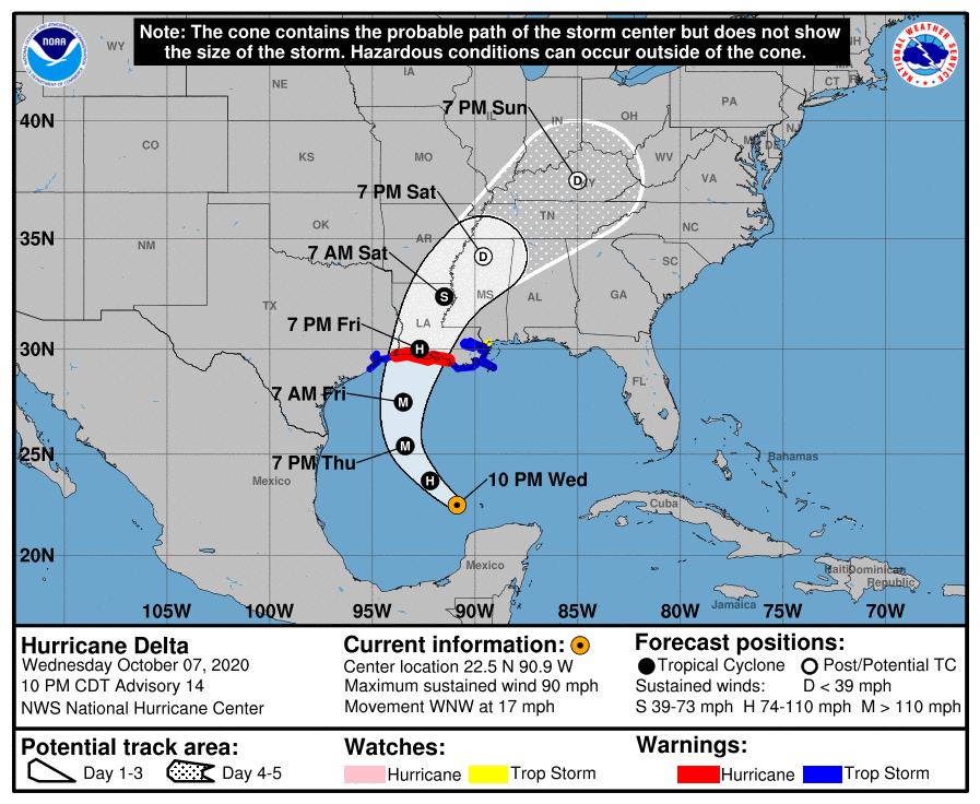
LOCATION…22.5N 90.9W
ABOUT 525 MI…845 KM SSE OF CAMERON LOUISIANA
MAXIMUM SUSTAINED WINDS…90 MPH…150 KM/H
PRESENT MOVEMENT…WNW OR 300 DEGREES AT 17 MPH…28 KM/H
MINIMUM CENTRAL PRESSURE…972 MB…28.71 INCHES
WATCHES AND WARNINGS
——————–
A Storm Surge Warning is in effect for…
* Sabine Pass to Ocean Springs, Mississippi including Calcasieu Lake, Vermilion Bay, Lake Pontchartrain, Lake Maurepas, and Lake Borgne
A Storm Surge Watch is in effect for…
* High Island, TX to Sabine Pass
* East of Ocean Springs, Mississippi to the Mississippi/Alabama border
A Hurricane Warning is in effect for…
* East of Sabine Pass to Morgan City, Louisiana
A Tropical Storm Warning is in effect for…
* San Luis Pass, Texas to Sabine Pass
* East of Morgan City, Louisiana to the mouth of the Pearl River, including New Orleans
* Lake Pontchartrain and Lake Maurepas
A Tropical Storm Watch is in effect for…
* East of the mouth of the Pearl River to Bay St. Louis Mississippi
DISCUSSION AND OUTLOOK
———————-
At 1000 PM CDT (0300 UTC), the center of Hurricane Delta was located near latitude 22.5 North, longitude 90.9 West. Delta is moving toward the west-northwest near 17 mph (28 km/h). A generally northwestward motion with a reduction in forward speed is expected through early Thursday. A north-northwestward motion is expected by late Thursday, and a faster northward to north-northeastward motion is forecast on Friday and Friday night. On the forecast track, the center of Delta will move over the southern and central Gulf of Mexico through Thursday and approach the northern Gulf coast within the hurricane warning area on Friday. Delta is forecast to move inland within the hurricane warning area by late Friday or Friday night.
Maximum sustained winds are near 90 mph (150 km/h) with higher gusts. Strengthening is forecast while the hurricane moves over the southern and central Gulf of Mexico through Thursday, and Delta is expected to become a major hurricane again. Some weakening is forecast as Delta approaches the northern Gulf coast on Friday.
Hurricane-force winds extend outward up to 35 miles (55 km) from the center and tropical-storm-force winds extend outward up to 140 miles (220 km).
The estimated minimum central pressure is 972 MB (28.71 inches).
HAZARDS AFFECTING LAND
———————-
STORM SURGE: The combination of a dangerous storm surge and the tide will cause normally dry areas near the coast to be flooded by rising waters moving inland from the shoreline. The water could reach the following heights above ground somewhere in the indicated areas if the peak surge occurs at the time of high tide…
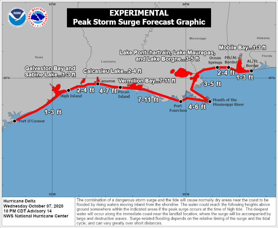
* Pecan Island to Port Fourchon, LA including Vermilion Bay…7-11 ft
* Cameron, LA to Pecan Island, LA…4-7 ft
* Port Fourchon, LA to the Mouth of the Mississippi River…4-6 ft
* The mouth of the Mississippi River to Ocean Springs, MS…3-5 ft
* Lake Borgne, Lake Pontchartrain, and Lake Maurepas…3-5 ft
* Ocean Springs, MS to MS/AL border…2-4 ft
* High Island, TX to Cameron, LA including Calcasieu Lake…2-4 ft
* MS/AL border to the AL/FL border including Mobile Bay…1-3 ft
* Sabine Lake…1-3 ft
* Port O’Connor, TX to High Island, TX including Galveston Bay…1-3 ft
The deepest water will occur along the immediate coast near and to the east of the landfall location, where the surge will be accompanied by large and dangerous waves. Surge-related flooding depends on the relative timing of the surge and the tidal cycle, and can vary greatly over short distances. For information specific to your area, please see products issued by your local National Weather Service forecast office.
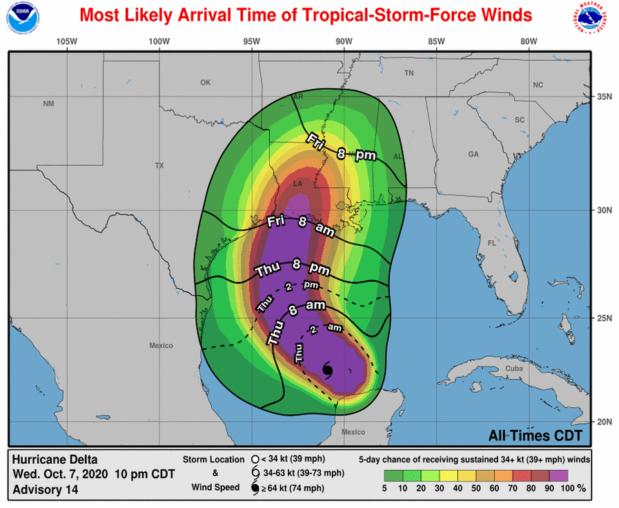
WIND: Hurricane conditions are expected within the hurricane warning area by Friday evening, with tropical storm conditions expected within this area earlier on Friday. Tropical storm conditions are expected within the tropical storm warning areas on Friday.
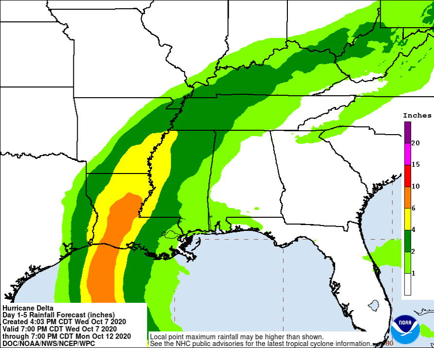
RAINFALL: Delta is expected to produce an additional 1 to 3 inches of rain over the far northwestern Yucatan Peninsula through early Thursday. The additional rainfall may still result in areas of significant flash flooding.
Friday through Saturday, Delta is expected to produce 4 to 8 inches of rain, with isolated maximum totals of 12 inches across portions of the central Gulf Coast north into portions of the Lower to Middle Mississippi Valley. These rainfall amounts will lead to flash, urban, small stream, and minor to isolated moderate river flooding. As Delta moves farther inland, 1 to 3 inches of rain, with locally higher amounts, is expected in the Ohio Valley and Mid Atlantic this weekend.
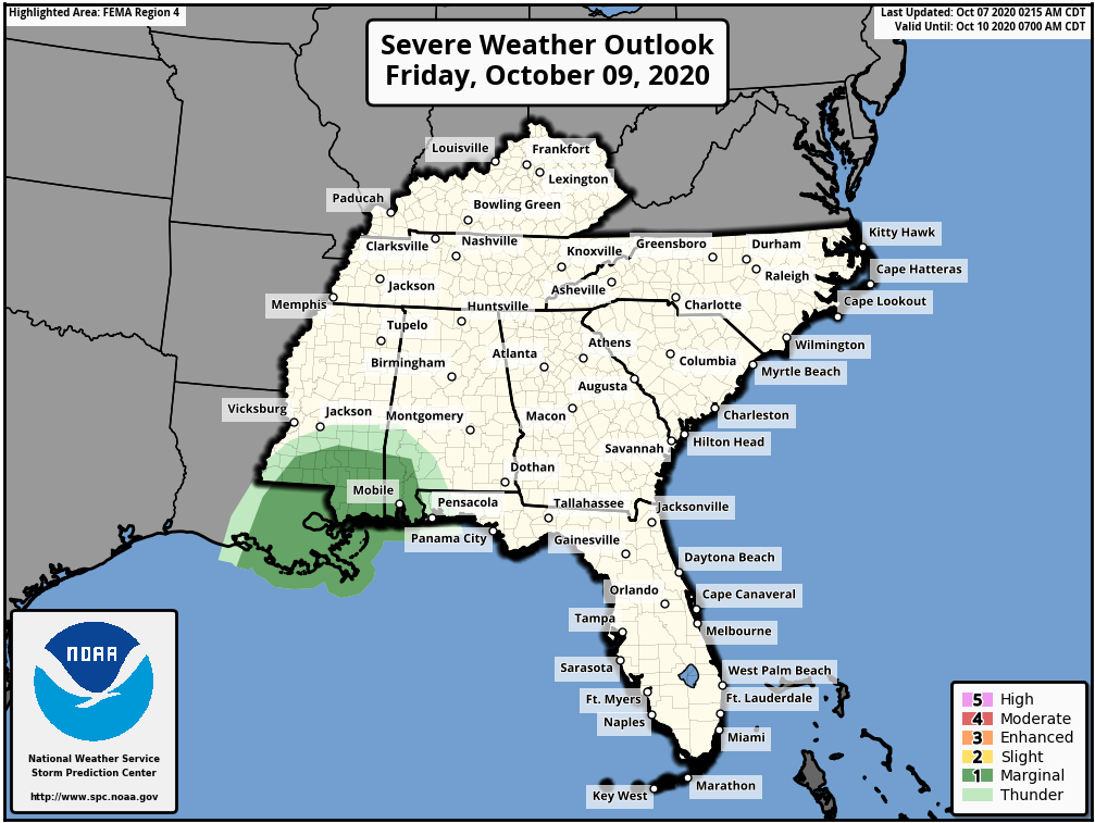
TORNADOES: The risk of a few tornadoes will increase late Thursday night into Friday over portions of southern Louisiana, southern Mississippi, and southwest Alabama.
SURF: Swells from Delta will begin to affect portions of the northern and western Gulf coast on Thursday. These swells are likely to cause life-threatening surf and rip current conditions.
Category: ALL POSTS, Severe Weather, Tropical
About the Author (Author Profile)
Scott Martin is an operational meteorologist, professional graphic artist, musician, husband, and father. Not only is Scott a member of the National Weather Association, but he is also the Central Alabama Chapter of the NWA president. Scott is also the co-founder of Racecast Weather, which provides forecasts for many racing series across the USA. He also supplies forecasts for the BassMaster Elite Series events including the BassMaster Classic.Subscribe
If you enjoyed this article, subscribe to receive more just like it.


