Delta Continues to Re-Intensify; Aircraft Investigating As of 7:00 am
SUMMARY OF 700 AM CDT…1200 UTC…INFORMATION
———————————————-
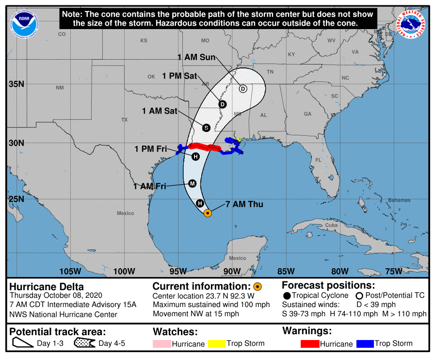
LOCATION…23.7N 92.3W
ABOUT 425 MI…685 KM S OF CAMERON LOUISIANA
MAXIMUM SUSTAINED WINDS…100 MPH…155 KM/H
PRESENT MOVEMENT…NW OR 305 DEGREES AT 15 MPH…24 KM/H
MINIMUM CENTRAL PRESSURE…970 MB…28.64 INCHES
WATCHES AND WARNINGS
——————–
A Storm Surge Warning is in effect for…
* Sabine Pass to Ocean Springs, Mississippi including Calcasieu Lake, Vermilion Bay, Lake Pontchartrain, Lake Maurepas, and Lake Borgne
A Storm Surge Watch is in effect for…
* High Island, TX to Sabine Pass
A Hurricane Warning is in effect for…
* East of Sabine Pass to Morgan City, Louisiana
A Tropical Storm Warning is in effect for…
* San Luis Pass, Texas to Sabine Pass
* East of Morgan City, Louisiana to the mouth of the Pearl River, including New Orleans
* Lake Pontchartrain and Lake Maurepas
A Tropical Storm Watch is in effect for…
* East of the mouth of the Pearl River to Bay St. Louis Mississippi
DISCUSSION AND OUTLOOK
———————-
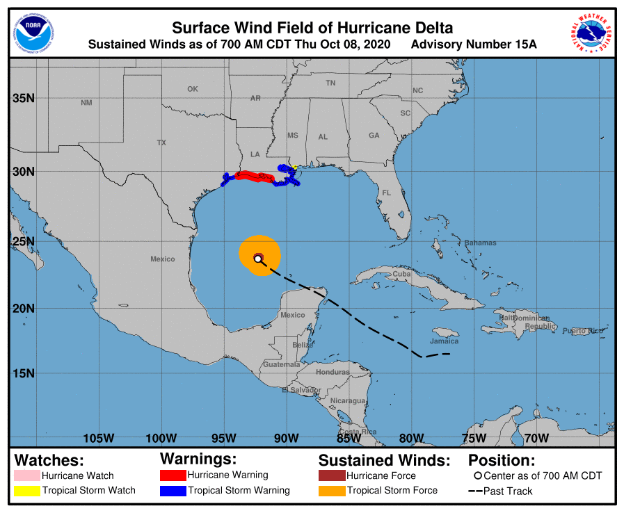
At 700 AM CDT (1200 UTC), the center of Hurricane Delta was located by NOAA and Air Force Reserve Hurricane Hunter aircraft near latitude 23.7 North, longitude 92.3 West. Delta is moving toward the northwest near 15 mph (24 km/h), and this motion with a reduction in forward speed is expected today. A turn to the north is forecast to occur by late tonight, followed by a north-northeastward motion by Friday night. On the forecast track, the center of Delta will move over the central Gulf of Mexico today and move inland within the hurricane warning area Friday afternoon or Friday night.
Reports from the Hurricane Hunter aircraft indicate that maximum sustained winds are near 100 mph (155 km/h) with higher gusts. Strengthening is forecast, and Delta is expected to become a major hurricane again by tonight. Some weakening is forecast when Delta approaches the northern Gulf coast on Friday.
Hurricane-force winds extend outward up to 35 miles (55 km) from the center and tropical-storm-force winds extend outward up to 125 miles (205 km).
The minimum central pressure just reported by the Hurricane Hunter aircraft is 970 MB (28.64 inches).
HAZARDS AFFECTING LAND
———————-
STORM SURGE: The combination of a dangerous storm surge and the tide will cause normally dry areas near the coast to be flooded by rising waters moving inland from the shoreline.
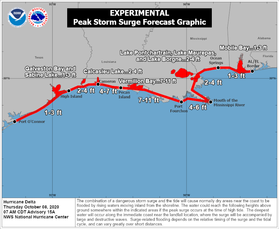
The water could reach the following heights above ground somewhere in the indicated areas if the peak surge occurs at the time of high tide…
* Pecan Island, LA to Port Fourchon, LA including Vermilion Bay…7-11 ft
* Cameron, LA to Pecan Island, LA…4-7 ft
* Port Fourchon, LA to the Mouth of the Mississippi River…4-6 ft
* The mouth of the Mississippi River to Ocean Springs, MS…2-4 ft
* Lake Borgne, Lake Pontchartrain, and Lake Maurepas…2-4 ft
* High Island, TX to Cameron, LA including Calcasieu Lake…2-4 ft
* Ocean Springs, MS to the AL/FL border including Mobile Bay…1-3 ft
* Sabine Lake…1-3 ft
* Port O’Connor, TX to High Island, TX including Galveston Bay…1-3 ft
The deepest water will occur along the immediate coast near and to the east of the landfall location, where the surge will be accompanied by large and dangerous waves. Surge-related flooding depends on the relative timing of the surge and the tidal cycle and can vary greatly over short distances.
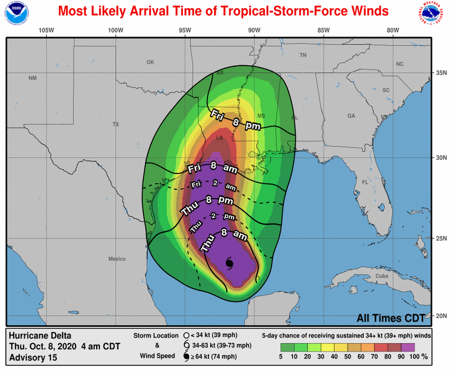
WIND: Hurricane conditions are expected within the hurricane warning area by Friday afternoon or evening, with tropical storm conditions expected within this area by early Friday. Tropical storm conditions are expected within the tropical storm warning areas on Friday.
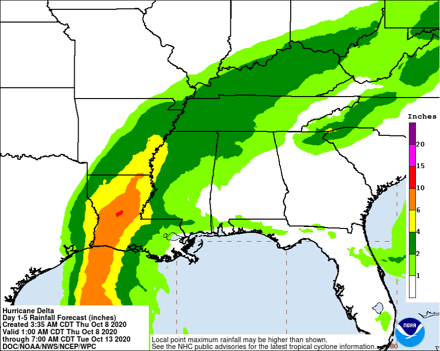
RAINFALL: Friday through Saturday, Delta is expected to produce 5 to 10 inches of rain, with isolated maximum totals of 15 inches, for southwest into south-central Louisiana. These rainfall amounts will lead to significant flash, urban, small stream flooding, along with minor to isolated moderate river flooding.
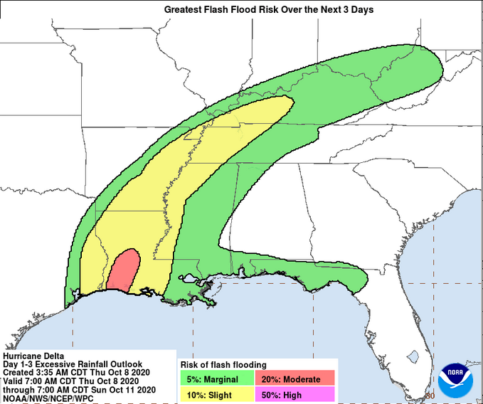
For extreme east Texas into northern Louisiana, southern Arkansas, and western Mississippi, Delta is expected to produce 3 to 6 inches of rain, with isolated maximum totals of 10 inches. These rainfall amounts will lead to flash, urban, small stream, and isolated minor river flooding.
As Delta moves farther inland, 1 to 3 inches of rain, with locally higher amounts, are expected in the Ohio Valley and Mid Atlantic this weekend.
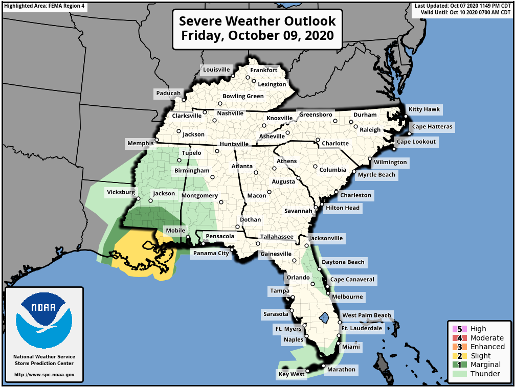
TORNADOES: A few tornadoes are possible late tonight through Friday over southern parts of Louisiana and Mississippi
SURF: Swells from Delta will begin to affect portions of the northern and western Gulf coast later today. These swells are likely to cause life-threatening surf and rip current conditions.
Category: ALL POSTS, Severe Weather, Tropical
About the Author (Author Profile)
Scott Martin is an operational meteorologist, professional graphic artist, musician, husband, and father. Not only is Scott a member of the National Weather Association, but he is also the Central Alabama Chapter of the NWA president. Scott is also the co-founder of Racecast Weather, which provides forecasts for many racing series across the USA. He also supplies forecasts for the BassMaster Elite Series events including the BassMaster Classic.Subscribe
If you enjoyed this article, subscribe to receive more just like it.


