10 a.m.: Delta Has Strengthened to 105 mph
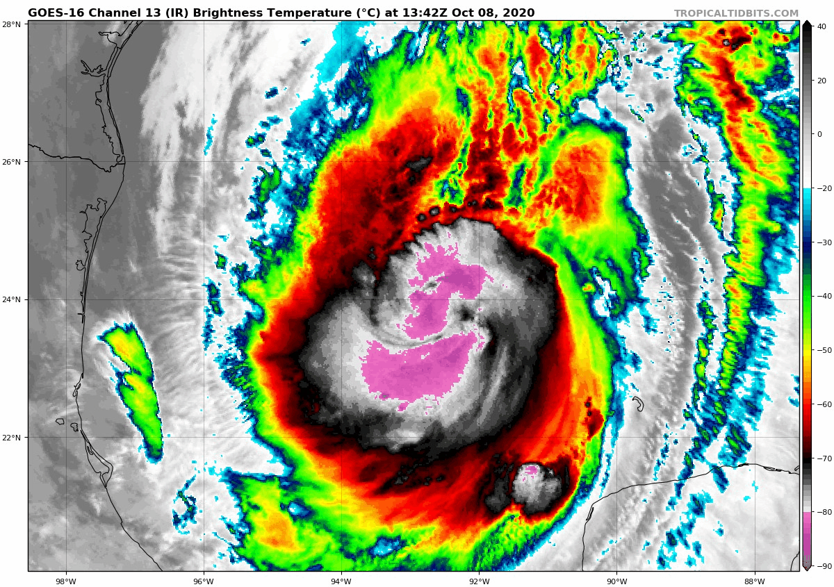
The 10 a.m. advisory is in and Delta is slightly stronger with top winds of 105 mph. An eye has appeared on infra-red satellite imagery and this would indicate the storm is better organized and likely to strengthen in coming hours. The eyewall is some 40 miles in diameter as evidenced by microwave satellite imagery before it appeared on infrared.
Intensity should peak around 115 mph later today, and there should be some weakening in the hours before landfall as the hurricane moves over cooler waters and encounters more shear.
Still, Delta will be a very dangerous hurricane on final approach, possibly still a major hurricane, but certainly one with winds in excess of 100 mph and with a storm surge of 7-11 feet near and east of the center at landfall with 1-3 feet all the way east to the Alabama coast.
It is moving northwest at a little slower speed and is expected to gradually turn more to the north and then north northeast over the next 24 hours.
The forecast cone is narrowing as the window to landfall closes. The cone now encompasses the coast from High Island, Texas (east of Houston) to the western side of Vermillion Bay near New Iberia.
Model tracks are all very consistent with the NHC forecast.
Landfall looks like it will come around 7 p.m. Friday in that cone, most likely just east of Cameron, Louisiana which was hit so hard by Hurricane Laura in August.
More damaging winds will spread into central Louisiana, causing more power outages, just after lines have been restored after Laura. Delta is likely to bring hurricane force gusts as far inland as Alexandria, LA.
The storm will move across northern Mississippi Saturday. Conditions should be improving at game time in Oxford for the Alabama-Ole Miss game, with rain still likely, but winds should be diminishing to less than 20 mph with gusts to 35 mph. No word yet on whether the game will be played as scheduled. The LSU – Missouri game has already been moved from Baton Rouge to Columbia. The Auburn – Arkansas game in Jordan-Hare will be played in gusty winds to about 30 mph with a chance of storms. Severe weather should not be a threat.
BULLETIN
Hurricane Delta Advisory Number 16
NWS National Hurricane Center Miami FL AL262020
1000 AM CDT Thu Oct 08 2020
…NOAA AND AIR FORCE RESERVE HURRICANE HUNTERS REPORT DELTA HAS
STRENGTHENED…
…HURRICANE CONDITIONS AND LIFE-THREATENING STORM SURGE EXPECTED
TO BEGIN ALONG PORTIONS OF THE NORTHERN GULF COAST ON FRIDAY…
SUMMARY OF 1000 AM CDT…1500 UTC…INFORMATION
———————————————–
LOCATION…24.0N 92.7W
ABOUT 400 MI…645 KM S OF CAMERON LOUISIANA
MAXIMUM SUSTAINED WINDS…105 MPH…165 KM/H
PRESENT MOVEMENT…NW OR 310 DEGREES AT 14 MPH…22 KM/H
MINIMUM CENTRAL PRESSURE…968 MB…28.59 INCHES
WATCHES AND WARNINGS
——————–
CHANGES WITH THIS ADVISORY:
A Storm Surge Warning is now in effect for the Texas coast from
High Island to Sabine Pass.
A Hurricane Warning is now in effect for the Texas coast from High
Island to Sabine Pass.
SUMMARY OF WATCHES AND WARNINGS IN EFFECT:
A Storm Surge Warning is in effect for…
* High Island Texas to Ocean Springs Mississippi including
Calcasieu Lake, Vermilion Bay, Lake Pontchartrain, Lake Maurepas,
and Lake Borgne
A Hurricane Warning is in effect for…
* High Island Texas to Morgan City Louisiana
A Tropical Storm Warning is in effect for…
* West of High Island to San Luis Pass Texas
* East of Morgan City Louisiana to the mouth of the Pearl River,
including New Orleans
* Lake Pontchartrain and Lake Maurepas
A Tropical Storm Watch is in effect for…
* East of the mouth of the Pearl River to Bay St. Louis Mississippi
A Storm Surge Warning means there is a danger of life-threatening
inundation, from rising water moving inland from the coastline,
during the next 36 hours in the indicated locations. For a
depiction of areas at risk, please see the National Weather
Service Storm Surge Watch/Warning Graphic, available at
hurricanes.gov. This is a life-threatening situation. Persons
located within these areas should take all necessary actions to
protect life and property from rising water and the potential for
other dangerous conditions. Promptly follow evacuation and other
instructions from local officials.
A Hurricane Warning means that hurricane conditions are expected
somewhere within the warning area. A warning is typically issued
36 hours before the anticipated first occurrence of
tropical-storm-force winds, conditions that make outside
preparations difficult or dangerous. Preparations to protect life
and property should be rushed to completion.
A Tropical Storm Warning means that tropical storm conditions are
expected somewhere within the warning area.
A Tropical Storm Watch means that tropical storm conditions are
possible within the watch area.
For storm information specific to your area, including possible
inland watches and warnings, please monitor products issued by your
local National Weather Service forecast office.
DISCUSSION AND OUTLOOK
———————-
At 1000 AM CDT (1500 UTC), the center of Hurricane Delta was located
near latitude 24.0 North, longitude 92.7 West. Delta is moving
toward the northwest near 14 mph (22 km/h), and this motion with a
reduction in forward speed is expected today. A turn toward the
north is forecast to occur by late tonight, followed by a north-
northeastward motion by Friday afternoon or Friday night. On the
forecast track, the center of Delta will move over the central Gulf
of Mexico today, over the northwestern Gulf of Mexico on Friday,
and then move inland within the hurricane warning area Friday
afternoon or Friday night.
Reports from NOAA and Air Force Reserve Hurricane Hunter aircraft
indicate that maximum sustained winds have increased to near 105
mph (165 km/h) with higher gusts. Additional strengthening is
forecast, and Delta is expected to become a major hurricane again
by tonight. Some weakening is possible as Delta approaches the
northern Gulf coast on Friday, with rapid weakening expected after
the center moves inland.
Hurricane-force winds extend outward up to 35 miles (55 km) from the
center and tropical-storm-force winds extend outward up to 125 miles
(205 km).
The latest minimum central pressure reported by the Hurricane
Hunter aircraft is 968 mb (28.59 inches).
HAZARDS AFFECTING LAND
———————-
Key messages for Delta can be found in the Tropical Cyclone
Discussion under AWIPS header MIATCDAT1, WMO header WTNT41
KNHC, and on the web at www.hurricanes.gov/text/MIATCDAT1.shtml.
STORM SURGE: The combination of a dangerous storm surge and the
tide will cause normally dry areas near the coast to be flooded by
rising waters moving inland from the shoreline. The water could
reach the following heights above ground somewhere in the indicated
areas if the peak surge occurs at the time of high tide…
Rockefeller Wildlife Refuge, LA to Port Fourchon, LA including
Vermilion Bay…7-11 ft
Holly Beach, LA to Rockefeller Wildlife Refuge, LA…4-7 ft
Port Fourchon, LA to the Mouth of the Mississippi River…4-6 ft
Sabine Pass to Holly Beach, LA…3-5 ft
Calcasieu Lake…3-5 ft
High Island, TX to Sabine Pass…2-4 ft
Mouth of the Mississippi River to Ocean Springs, MS…2-4 ft
Lake Borgne, Lake Pontchartrain, and Lake Maurepas…2-4 ft
Ocean Springs, MS to the AL/FL border including Mobile Bay…1-3 ft
Sabine Lake…1-3 ft
Port O’Connor, TX to High Island, TX including Galveston Bay…
1-3 ft
The deepest water will occur along the immediate coast near and to
the east of the landfall location, where the surge will be
accompanied by large and dangerous waves. Surge-related flooding
depends on the relative timing of the surge and the tidal cycle,
and can vary greatly over short distances. For information
specific to your area, please see products issued by your local
National Weather Service forecast office.
WIND: Hurricane conditions are expected within the hurricane
warning area by Friday afternoon or evening, with tropical storm
conditions expected within this area by early Friday. Tropical
storm conditions are expected within the tropical storm warning
areas on Friday, and are possible in the tropical storm watch area
Friday night.
RAINFALL: Friday through Saturday, Delta is expected to produce 5
to 10 inches of rain, with isolated maximum totals of 15 inches,
from southwest into south-central Louisiana. These rainfall amounts
will lead to significant flash, urban, small stream flooding, along
with minor to isolated moderate river flooding.
For extreme east Texas into northern Louisiana, southern Arkansas
and western Mississippi, Delta is expected to produce 3 to 6 inches
of rain, with isolated maximum totals of 10 inches. These rainfall
amounts will lead to flash, urban, small stream and isolated minor
river flooding.
As Delta moves farther inland, 1 to 3 inches of rain, with locally
higher amounts, are expected in the Ohio Valley and Mid Atlantic
this weekend.
TORNADOES: A few tornadoes are possible late tonight through Friday
over southern parts of Louisiana and Mississippi
SURF: Swells from Delta will begin to affect portions of the
northern and western Gulf coast later today. These swells are likely
to cause life-threatening surf and rip current conditions. Please
consult products from your local weather office.
NEXT ADVISORY
————-
Next intermediate advisory at 100 PM CDT.
Next complete advisory at 400 PM CDT.
$$
Forecaster Beven
About the Author (Author Profile)
Bill Murray is the President of The Weather Factory. He is the site's official weather historian and a weekend forecaster. He also anchors the site's severe weather coverage. Bill Murray is the proud holder of National Weather Association Digital Seal #0001 @wxhistorianSubscribe
If you enjoyed this article, subscribe to receive more just like it.


