Delta Weakens a Little as of 10:00 am, Still a Very Dangerous Category 3 Hurricane
SUMMARY OF 1000 AM CDT…1500 UTC…INFORMATION
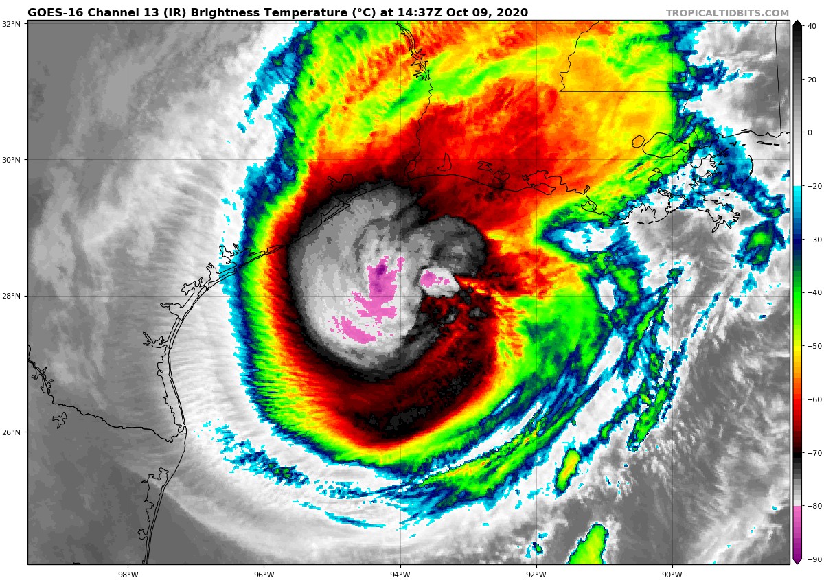
LOCATION…28.0N 93.8W
ABOUT 130 MI…205 KM SSW OF CAMERON LOUISIANA
MAXIMUM SUSTAINED WINDS…115 MPH…185 KM/H
PRESENT MOVEMENT…N OR 0 DEGREES AT 13 MPH…20 KM/H
MINIMUM CENTRAL PRESSURE…962 MB…28.41 INCHES
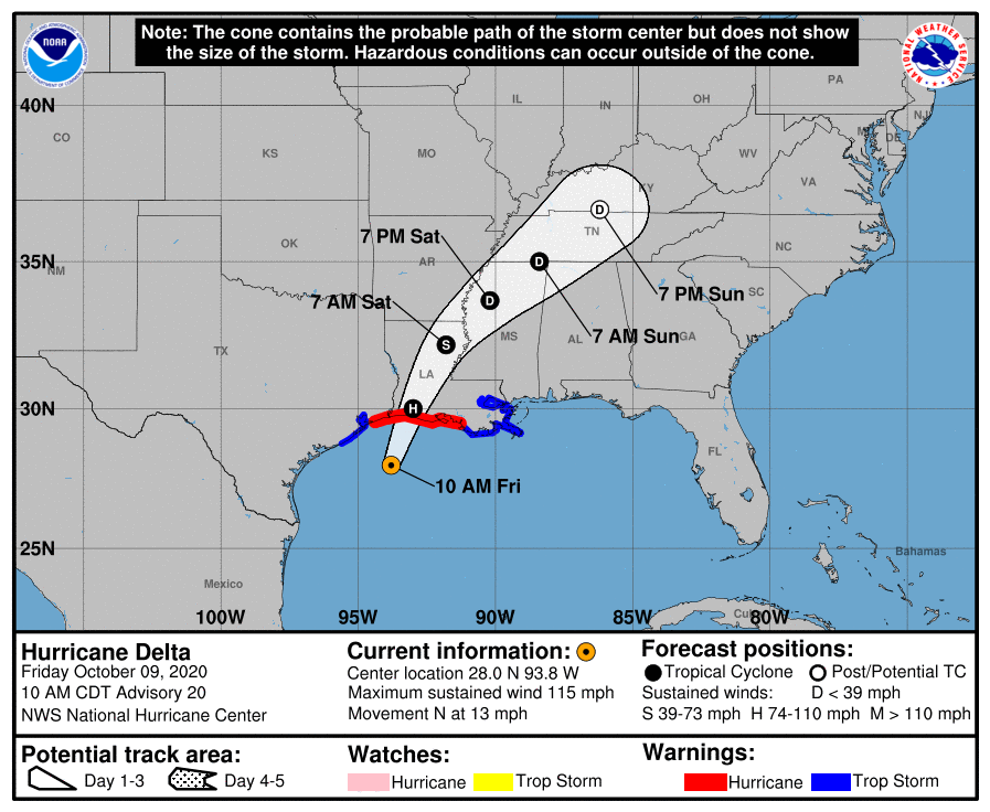
WATCHES AND WARNINGS
A Storm Surge Warning is in effect for…
* High Island Texas to the Mouth of the Pearl River including Calcasieu Lake, Vermilion Bay, and Lake Borgne
A Hurricane Warning is in effect for…
* High Island Texas to Morgan City Louisiana
A Tropical Storm Warning is in effect for…
* West of High Island to Sargent Texas
* East of Morgan City Louisiana to the mouth of the Pearl River, including New Orleans
* Lake Pontchartrain and Lake Maurepas
DISCUSSION AND OUTLOOK
At 1000 AM CDT (1500 UTC), the center of Hurricane Delta was located near latitude 28.0 North, longitude 93.8 West. Delta is moving toward the north near 13 mph (20 km/h). A turn toward the north-northeast is expected this afternoon, followed by a northeastward motion during the day Saturday. On the forecast track, the center of Delta should make landfall along the coast of southwestern Louisiana later this afternoon or this evening and then move across central and northeastern Louisiana tonight and Saturday morning.
Maximum sustained winds are near 115 mph (185 km/h) with higher gusts. Delta is a category 3 hurricane on the Saffir-Simpson Hurricane Wind Scale. Slow weakening is expected before landfall, with rapid weakening expected after the center moves inland.
Hurricane-force winds extend outward up to 40 miles (65 km) from the center and tropical-storm-force winds extend outward up to 160 miles (260 km). NOAA buoy 42019 located west of the center of Delta recently reported sustained winds of 49 mph (79 km/h) and a wind gust of 60 mph (97 km/h).
The latest minimum central pressure reported by a NOAA Hurricane Hunter aircraft is 962 MB (28.41 inches).
HAZARDS AFFECTING LAND
STORM SURGE: The combination of a dangerous storm surge and the tide will cause normally dry areas near the coast to be flooded by rising waters moving inland from the shoreline. The water could reach the following heights above ground somewhere in the indicated areas if the peak surge occurs at the time of high tide…
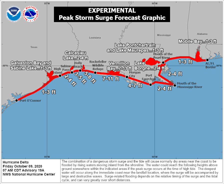
Rockefeller Wildlife Refuge, LA to Morgan City, LA including Vermilion Bay…7-11 ft
Holly Beach, LA to Rockefeller Wildlife Refuge, LA…5-8 ft
Sabine Pass to Holly Beach, LA…3-5 ft
Morgan City, LA to Port Fourchon, LA…4-7 ft
Calcasieu Lake…2-4 ft
High Island, TX to Sabine Pass…2-4 ft
Port Fourchon, LA to the Mouth of the Pearl River…2-4 ft
Lake Borgne…2-4 ft
Lake Pontchartrain and Lake Maurepas…1-3 ft
The mouth of the Pearl River, LA to the AL/FL border including Mobile Bay…1-3 ft
Sabine Lake…1-3 ft
Port O’Connor, TX to High Island, TX including Galveston Bay…1-3 ft
It is important to note that small changes in the track, structure, or intensity of Delta could have large impacts on where the highest storm surge occurs. Users are urged to stay tuned for possible changes and updates.
The deepest water will occur along the immediate coast near and to the east of the landfall location, where the surge will be accompanied by large and dangerous waves. Surge-related flooding depends on the relative timing of the surge and the tidal cycle and can vary greatly over short distances.
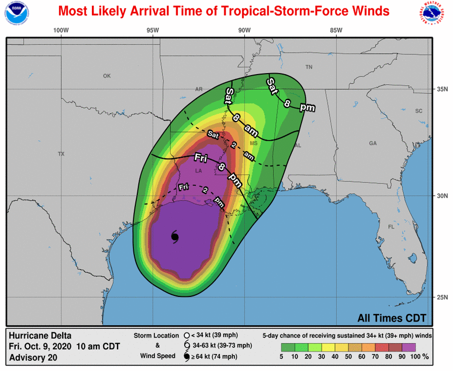
WIND: Hurricane conditions are expected within the hurricane warning area by this afternoon, with tropical storm conditions beginning within this area in the next few hours. Tropical storm conditions are expected within the tropical storm warning areas during the next several hours.
RAINFALL: Today through Saturday, Delta is expected to produce 5 to 10 inches of rain, with isolated maximum totals of 15 inches, from southwest into central Louisiana. These rainfall amounts will lead to significant flash, urban, small stream flooding, along with minor to major river flooding.
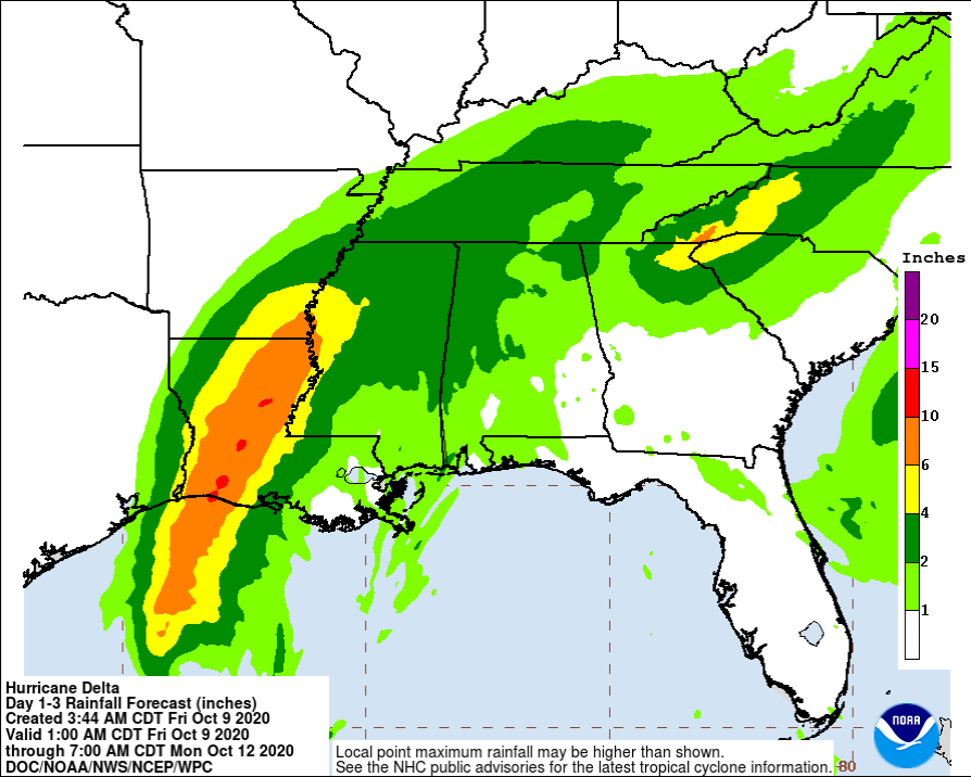
For extreme east Texas into northern Louisiana, southern Arkansas, and western Mississippi, Delta is expected to produce 3 to 6 inches of rain, with isolated maximum totals of 10 inches. These rainfall amounts will lead to flash, urban, small stream, and isolated minor river flooding.
As the remnants of Delta move further inland, 1 to 3 inches of rain, with locally higher amounts, are expected in the Tennessee Valley and Mid Atlantic this weekend. There is a potential for 3 to 6 inches in the Southern Appalachians, which could lead to isolated flash, urban, and small stream flooding.
TORNADOES: A few tornadoes are possible today and tonight over southern portions of Louisiana and Mississippi.
SURF: Swells from Delta are affecting portions of the northern and western Gulf coast. These swells are likely to cause life-threatening surf and rip current conditions.
Category: ALL POSTS, Severe Weather, Tropical
About the Author (Author Profile)
Scott Martin is an operational meteorologist, professional graphic artist, musician, husband, and father. Not only is Scott a member of the National Weather Association, but he is also the Central Alabama Chapter of the NWA president. Scott is also the co-founder of Racecast Weather, which provides forecasts for many racing series across the USA. He also supplies forecasts for the BassMaster Elite Series events including the BassMaster Classic.Subscribe
If you enjoyed this article, subscribe to receive more just like it.


