Weather Xtreme Video: Wet, Breezy, & the Potential for a Tornado or Two Today
TODAY: The center of Tropical Storm Delta will be moving through Mississippi before making a right turn and moving through the northwestern parts of Alabama this evening and into tonight. While Delta as a tropical system will continue to weaken throughout the day, a combination of rising instability across Central Alabama and elevated helicity moving in with Delta will put us in a risk for the potential of a few tornadoes today.
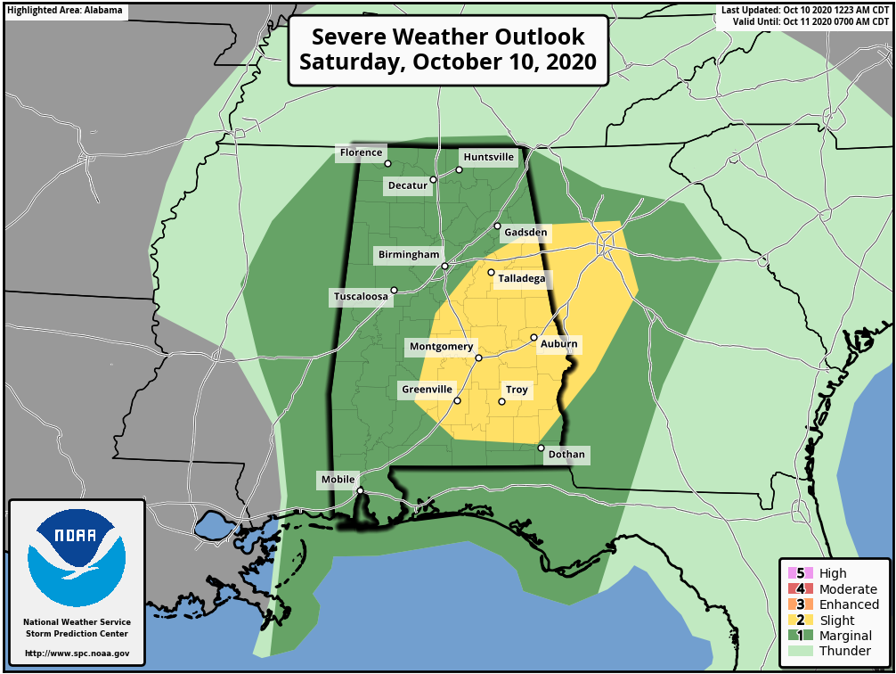
SPC has all of the southeastern and much of the eastern parts of Central Alabama in a Slight Risk for severe storms throughout the day today, while the rest of the area is under a Marginal Risk. The main window for the threat of tornadoes will be from 9:00 am through 11:00 pm tonight from west to east. Any tornadoes that do form will be quick, spin-ups that may be hard to detect just as you would expect to have with tropical systems. While most of them will be smaller EF-0s to EF-1s, there is a non-zero threat of a stronger tornado.
Other than that, we can expect today to be cloudy at times with occasional rain and a few thunderstorms, continuing through tonight and through the overnight hours. Highs will be in the mid-70s to the lower 80s. Since we have been dry for a little while, flooding should not be an issue, but some locations along and north of the I-59 corridor could see as much as 2.00-3.00 inches of rain, while south of that will see 1.00-2.00 inches through Sunday night. Be sure you have a way to get severe weather warnings in a trustworthy fashion if they are needed to be issued and go over your severe weather safety plan.
_____
SUNDAY: Much of the rain should come to an end late in the day on Sunday, but a few lingering showers may be possible through the evening. Skies will be cloudy otherwise and highs will be in the mid-70s to the lower 80s on both days.
_____
THE WORKWEEK AHEAD: Once we get the remnants of Delta out of the area, the weather will feature dry days with plenty of sunshine with warm temperatures to start, but a cold front sweeps through Central Alabama late on Monday which will drop our highs back into the mild category. Monday’s highs will be in the mid to upper 80s, falling back into the upper 70s to the mid-80s for Tuesday, then the mid-70s to the lower 80s for Wednesday. High pressure will move into the western portions of the Carolinas on Thursday which will send some cooler air in our direction, but it may take a full day for those highs to drop a little. Thursday will be in the mid-70s to right around 80 degrees, then falling back into the upper 60s to the upper 70s on Friday.
_____
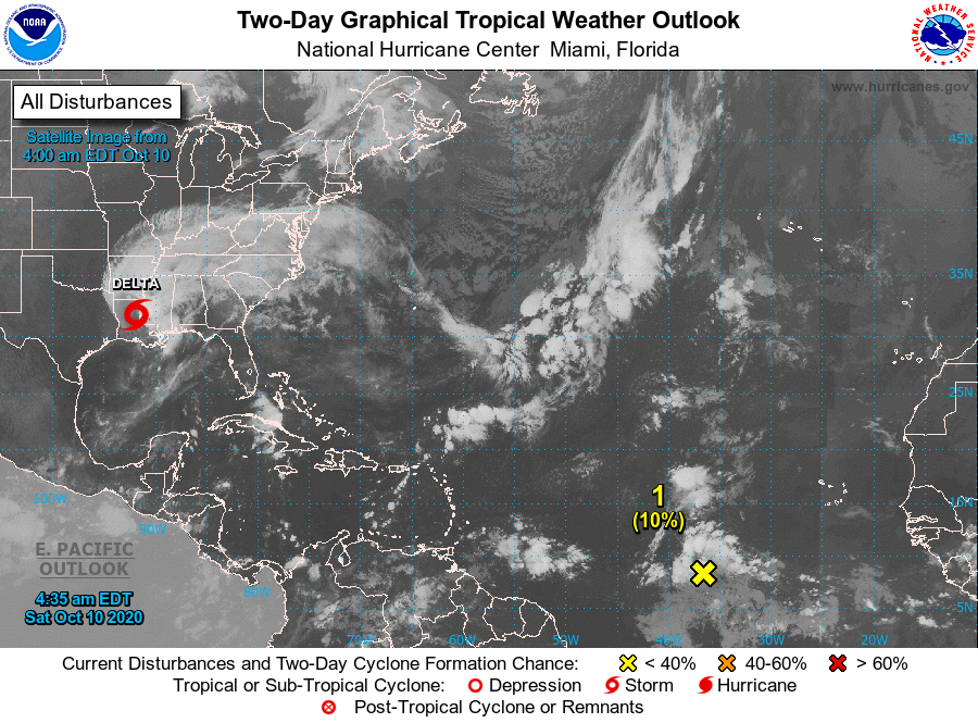
THE TROPICS: As of 4:00 am, Delta was located around 45 miles to the south-southeast of Monroe, Louisiana, with maximum sustained winds at 45 mph. Movement was still to the north-northeast at 16 mph with a turn to the northeast expected later today. On the forecast track, the center of Delta should move across northeastern Louisiana this morning and then across northern Mississippi and into the Tennessee Valley later today and Sunday. Delta will continue to weaken and will transition down to a tropical depression later today.
We also have a westward-moving tropical wave that is producing disorganized showers and thunderstorms over the central tropical Atlantic. Slow development of this system could be possible later this weekend or early next week while the wave continues moving westward at 15 to 20 mph. Upper-level winds are forecast to become unfavorable for further development by the middle of next week.
* Formation chance through 48 hours…low…10 percent.
* Formation chance through 5 days…low…20 percent.
Category: Alabama's Weather, ALL POSTS, Severe Weather, Tropical, Weather Xtreme Videos
About the Author (Author Profile)
Scott Martin is an operational meteorologist, professional graphic artist, musician, husband, and father. Not only is Scott a member of the National Weather Association, but he is also the Central Alabama Chapter of the NWA president. Scott is also the co-founder of Racecast Weather, which provides forecasts for many racing series across the USA. He also supplies forecasts for the BassMaster Elite Series events including the BassMaster Classic.Subscribe
If you enjoyed this article, subscribe to receive more just like it.


