Strong Storms Affecting Lauderdale & Colbert Counties
…SIGNIFICANT WEATHER ADVISORY FOR NORTHWESTERN LAUDERDALE AND
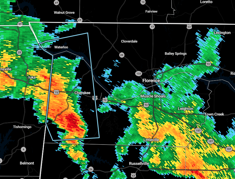
WESTERN COLBERT COUNTIES UNTIL 615 PM CDT…
At 527 PM CDT, Doppler radar was tracking a strong thunderstorm 7
miles southwest of Cherokee, or 9 miles east of Tishomingo State
Park, moving north at 20 mph.
Winds gusts of 40 to 50 mph will be possible with this storm.
Locations impacted include…
Cherokee, Waterloo, Malone, Mynot, Mt Hester, Margerum, Maud,
Allsboro, Riverton and Wright.
PRECAUTIONARY/PREPAREDNESS ACTIONS…
Strong gusty winds will be capable of knocking down small tree limbs
along with other small unsecured items. Seek safe shelter until this
storm has passed.
Category: Alabama's Weather, ALL POSTS, Severe Weather
About the Author (Author Profile)
Scott Martin is an operational meteorologist, professional graphic artist, musician, husband, and father. Not only is Scott a member of the National Weather Association, but he is also the Central Alabama Chapter of the NWA president. Scott is also the co-founder of Racecast Weather, which provides forecasts for many racing series across the USA. He also supplies forecasts for the BassMaster Elite Series events including the BassMaster Classic.Subscribe
If you enjoyed this article, subscribe to receive more just like it.


