Zeta Expected to Bring Hurricane Conditions to Portions of the Northern Gulf of Mexico Coast on Wednesday
SUMMARY OF 1000 AM CDT…1500 UTC…INFORMATION
———————————————–
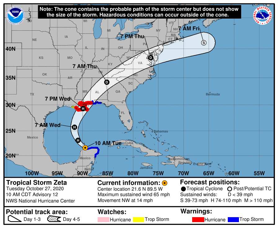
LOCATION…21.6N 89.5W
ABOUT 25 MI…40 KM NNE OF PROGRESO MEXICO
ABOUT 520 MI…835 KM S OF THE MOUTH OF THE MISSISSIPPI RIVER
MAXIMUM SUSTAINED WINDS…65 MPH…100 KM/H
PRESENT MOVEMENT…NW OR 305 DEGREES AT 14 MPH…22 KM/H
MINIMUM CENTRAL PRESSURE…985 MB…29.09 INCHES
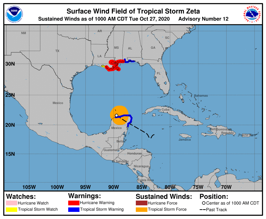
WATCHES AND WARNINGS
——————–
A Storm Surge Warning is in effect for…
* Intracoastal City Louisiana to Navarre Florida
* Lake Borgne, Lake Pontchartrain, Vermilion Bay, Pensacola Bay, and Mobile Bay
A Hurricane Warning is in effect for…
* Morgan City Louisiana to the Mississippi/Alabama border
* Lake Pontchartrain, Lake Maurepas, and Metropolitan New Orleans
A Tropical Storm Warning is in effect for…
* Punta Allen to Progreso Mexico
* Cozumel
* Mississippi/Alabama border to Okaloosa/Walton County Line Florida
A Tropical Storm Watch is in effect for…
* West of Morgan City to Intracoastal City Louisiana
DISCUSSION AND OUTLOOK
———————-
At 1000 AM CDT (1500 UTC), the center of Tropical Storm Zeta was located just offshore of the northern coast of the Yucatan Peninsula near latitude 21.6 North, longitude 89.5 West. Zeta is moving toward the northwest near 14 mph (22 km/h), and this general motion is forecast to continue today. Zeta should turn toward the north tonight, and a faster northward to north-northeastward motion is expected on Wednesday. On the forecast track, the center of Zeta will move over the southern Gulf of Mexico later today and over the central Gulf of Mexico tonight. Zeta is forecast to approach the northern Gulf Coast on Wednesday, make landfall within the hurricane warning area late Wednesday or Wednesday night, and move inland across the southeastern United States early Thursday.
Maximum sustained winds are near 65 mph (100 km/h) with higher gusts. Zeta is forecast to re-strengthen while it moves over the southern Gulf of Mexico, and become a hurricane again later today. Zeta is forecast to be at or near hurricane strength when it reaches the northern Gulf Coast late Wednesday.
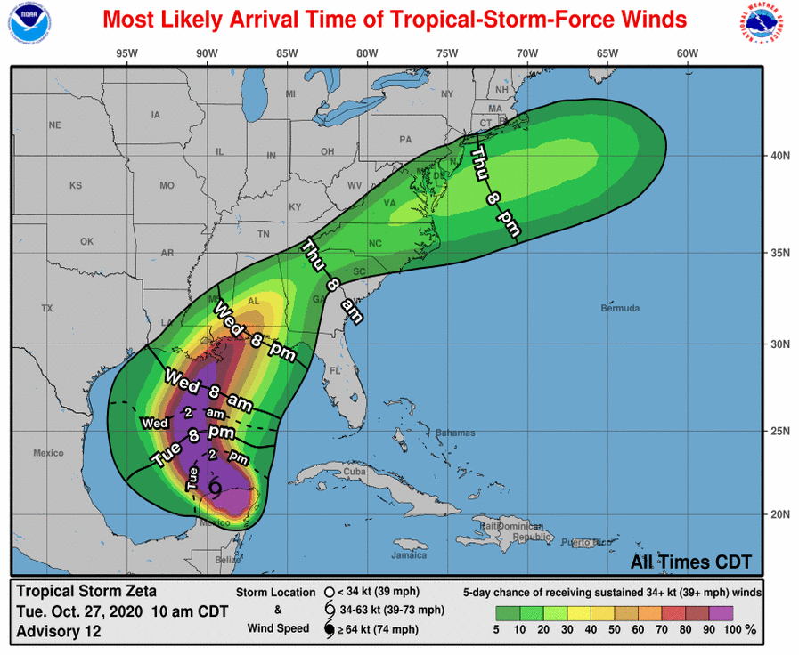
Tropical-storm-force winds extend outward up to 140 miles (220 km) from the center.
The estimated minimum central pressure is 985 MB (29.09 inches).
HAZARDS AFFECTING LAND
———————-
STORM SURGE: Along the northern Gulf Coast, the combination of a dangerous storm surge and the tide will cause normally dry areas near the coast to be flooded by rising waters moving inland from the shoreline. The water could reach the following heights above ground somewhere in the indicated areas if the peak surge occurs at the time of high tide…
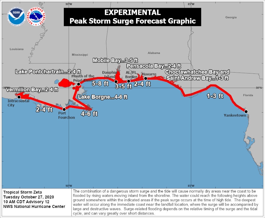
The mouth of the Pearl River to Dauphin Island AL…5-8 ft
Port Fourchon LA to the Mouth of the Pearl River including Lake Borgne…4-6 ft
Dauphin Island AL to AL/FL border including Mobile Bay…3-5 ft
Intracoastal City LA to Port Fourchon LA including Vermilion Bay…2-4 ft
AL/FL border to Navarre FL including Pensacola Bay…2-4 ft
Lake Pontchartrain…2-4 ft
Navarre FL to Yankeetown FL including Choctawhatchee Bay and Saint Andrew Bay…1-3 ft
The deepest water will occur along the immediate coast near and to the right of the landfall location, where the surge will be accompanied by large and dangerous waves. Surge-related flooding depends on the relative timing of the surge and the tidal cycle and can vary greatly over short distances. For information specific to your area, please see products issued by your local National Weather Service forecast office.
Water levels along the coast of the Yucatan Peninsula of Mexico will gradually subside today as Zeta moves away from the area.
WIND: Tropical storm conditions will continue within the warning area in Mexico for the next few hours.
Hurricane conditions are expected within the Hurricane Warning area on the northern Gulf Coast late Wednesday, with tropical storm conditions beginning Wednesday afternoon. Tropical storm conditions are expected within the Tropical Storm Warning area on the northern Gulf Coast by late Wednesday, and tropical storm conditions are possible within the Tropical Storm Watch area late Wednesday.
Damaging winds, especially in gusts, will spread well inland across portions of southeast Mississippi and southern Alabama Wednesday night.
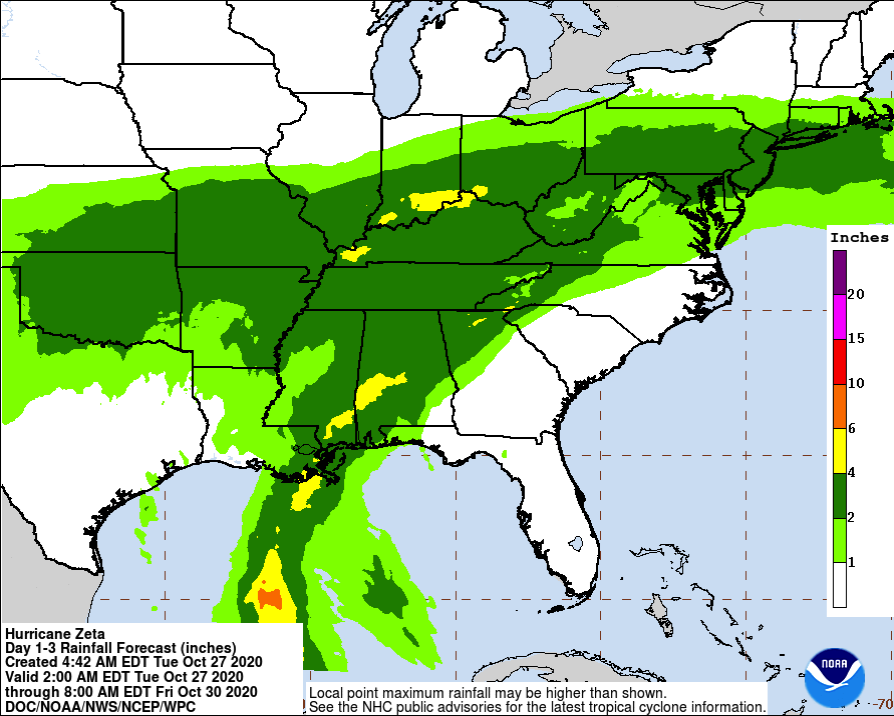
RAINFALL: Rainfall totals of 4 to 8 inches with local amounts of 12 inches are possible through today across the Yucatan Peninsula of Mexico and the Cayman Islands. An additional 1 to 3 inches of rain will be possible across western Cuba through Tuesday.
An initial area of heavy rains will begin to impact the central Gulf Coast tonight, with the core of heavy rains spreading north into the Ohio Valley and Mid-Atlantic through Thursday, near and in advance of Zeta. Rainfall totals of 2 to 4 inches with isolated amounts of 6 inches are expected across these areas, resulting in flash, urban, small stream, and minor river flooding.
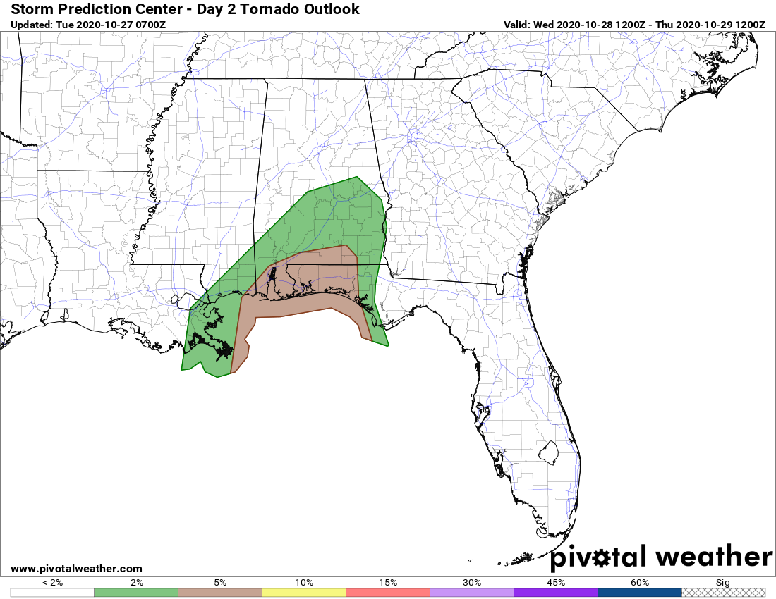
TORNADOES: A few tornadoes are possible Wednesday and Wednesday night over southeastern Mississippi, southern Alabama, and the western Panhandle of Florida.
Category: ALL POSTS, Severe Weather, Tropical
About the Author (Author Profile)
Scott Martin is an operational meteorologist, professional graphic artist, musician, husband, and father. Not only is Scott a member of the National Weather Association, but he is also the Central Alabama Chapter of the NWA president. Scott is also the co-founder of Racecast Weather, which provides forecasts for many racing series across the USA. He also supplies forecasts for the BassMaster Elite Series events including the BassMaster Classic.Subscribe
If you enjoyed this article, subscribe to receive more just like it.


