Cloudy with a Single Shower Out There at Midday; Potential Impacts from Zeta in Central Alabama
WEATHER FOR THE REST OF TUESDAY
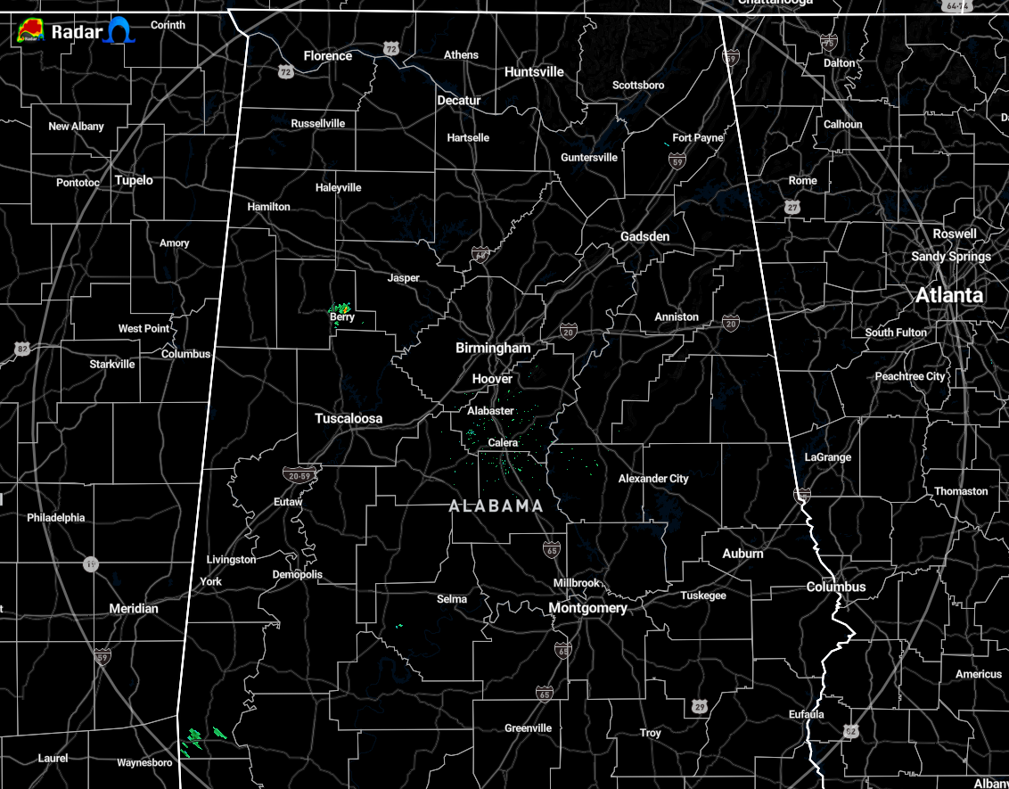
Radar is currently showing a light shower over and just north of Berry in Fayette County, while the rest of Central Alabama looks to be dry as of 11:20 am. The rest of the area is under a large cloud deck with only a few breaks to allow a small amount of sunshine to reach the surface. Temperatures across the area are ranging from as low as 64 degrees in Haleyville to as warm as 77 degrees in Montgomery and Troy. Birmingham was sitting at 71 degrees.
Shower and thunderstorm chances will start to increase across Central Alabama from southwest to northeast as the tropical moisture associated with Zeta will start to quickly move northward toward the Northern Gulf Coast. The highest rain chances will be over the southwestern and extreme southern locations during the daylight hours, with a small chance for showers over the eastern and northeastern parts. However, rain will be likely for everyone in Central Alabama starting tonight and through the overnight hours. When it’s not raining, the skies will be mainly cloudy. Afternoon highs will be in the mid-70s to the lower 80s with overnight lows in the mid-60s to the lower 70s.
ZETA IMPACTS FOR LOCATIONS NOT IN TROPICAL STORM WATCH
WIND: Maximum sustained winds are expected to be 10-25 MPH with gusts up to 30 MPH north of the I-59 corridor, 25-45 MPH with gust exceeding 50 MPH south of I-59 down to the I-85 corridor, and 20-40 MPH with gusts up to 50 MPH along and south of I-85. A Wind Advisory will more than likely be issued later today for a good part of Central Alabama.
RAINFALL: Amounts will reach as high as 2-4 inches north of the Tropical Storm Watch locations while the southeastern locations not in the watch will receive 2 inches or less.
TORNADOES: A brief spin-up tornado or two will be possible along and south of a line from roughly Demopolis to Clanton to Lafayette. However, with the system moving through during the late-night and overnight hours, the lack of instability will keep the odds of any tornado formation rather low.

TROPICAL STORM WATCH: THREATS & IMPACTS
COUNTIES UNDER TROPICAL STORM WATCH: Autauga, Chilton, Coosa, Dallas, Elmore, Lowndes, Marengo, Montgomery, Perry counties in Central Alabama until further notice.
WIND: Maximum sustained winds of 35-45 MPH with gusts to 55 MPH starting on Wednesday evening and lasting through early Thursday morning.
Potential significant impacts include…
• Some damage to roofing and siding materials, along with damage to porches, awnings, carports, and sheds. A few buildings experiencing window, door, and garage door failures. Mobile homes damaged, especially if unanchored. Unsecured lightweight objects become dangerous projectiles.
• Several large trees snapped or uprooted, but with greater numbers in places where trees are shallow-rooted. Several fences and roadway signs may be blown over.
• Some roads impassable from large debris, and more within urban or heavily wooded places. A few bridges, causeways, and access routes impassable.
• Scattered power and communications outages, but more prevalent in areas with above-ground lines.
Plan, prepare, & act…
• Plan for dangerous wind of equivalent strong tropical storm force.
• Remaining efforts to protect life and property should be completed as soon as possible. Prepare for significant wind damage.
• Move to safe shelter before the wind becomes hazardous.
RAINFALL: Peak rainfall amounts may reach as high as 3-6 inches, with locally higher amounts through Thursday evening.
Potential significant impacts include…
• Moderate rainfall flooding may prompt several evacuations and rescues.
• Rivers and tributaries may quickly become swollen with swifter currents and overspill their banks in a few places, especially in usually vulnerable spots. Small streams, creeks, canals, arroyos, and ditches overflow.
• Flood waters can enter some structures or weaken foundations. Several places may experience expanded areas of rapid inundation at underpasses, low-lying spots, and poor drainage areas. Some streets and parking lots take on moving water as storm drains and retention ponds overflow. Driving conditions become hazardous. Some road and bridge closures.
Plan, prepare, & act…
• Emergency plans should include the potential for moderate flooding from heavy rain. Evacuations and rescues are possible.
• Consider protective actions if you are in an area vulnerable to flooding.
• Heed any flood watches and warnings. Failure to take action may result in serious injury or loss of life.
TORNADOES: The situation is somewhat favorable for a couple of brief spin-up tornadoes during a window from 7:00 pm Wednesday to 7:00 am Thursday.
Potential limited impacts include…
• The occurrence of isolated tornadoes can hinder the execution of emergency plans during tropical events.
• A few places may experience tornado damage, along with power and communications disruptions.
• Locations could realize roofs peeled off buildings, chimneys toppled, mobile homes pushed off foundations or overturned, large tree tops and branches snapped off, shallow-rooted trees knocked over, moving vehicles blown off roads, and boats pulled from moorings.
Plan, prepare, & act…
• Emergency plans should include the potential for a few tornadoes.
• If your shelter is particularly vulnerable to tornadoes, prepare to relocate to a safe shelter before hazardous weather arrives.
• If a tornado warning is issued, be ready to shelter quickly.
Category: Alabama's Weather, ALL POSTS, Severe Weather, Tropical
About the Author (Author Profile)
Scott Martin is an operational meteorologist, professional graphic artist, musician, husband, and father. Not only is Scott a member of the National Weather Association, but he is also the Central Alabama Chapter of the NWA president. Scott is also the co-founder of Racecast Weather, which provides forecasts for many racing series across the USA. He also supplies forecasts for the BassMaster Elite Series events including the BassMaster Classic.Subscribe
If you enjoyed this article, subscribe to receive more just like it.


