Detailed Wind Threat Forecast for Alabama
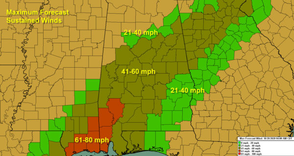
A swath of 40-60 mph winds will spread across Central Alabama tonight as the center of Zeta traverses the state between 10 p.m. and 4 a.m.
These winds will cause extensive tree and power line damage. There will be widespread power outages.
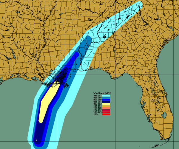
Here is the wind forecast based on the official 4 a.m. NHC forecast:
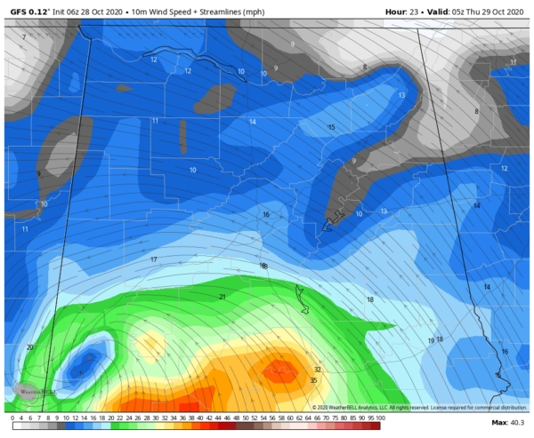
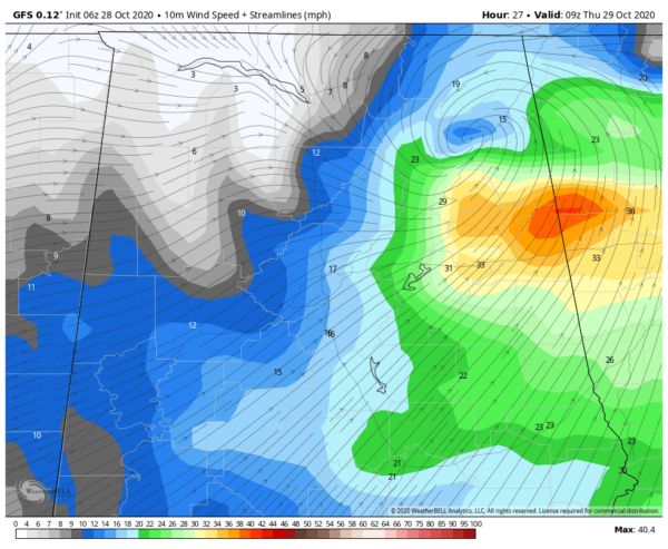
Here is a wind map of sustained winds using the GFS at midnight:
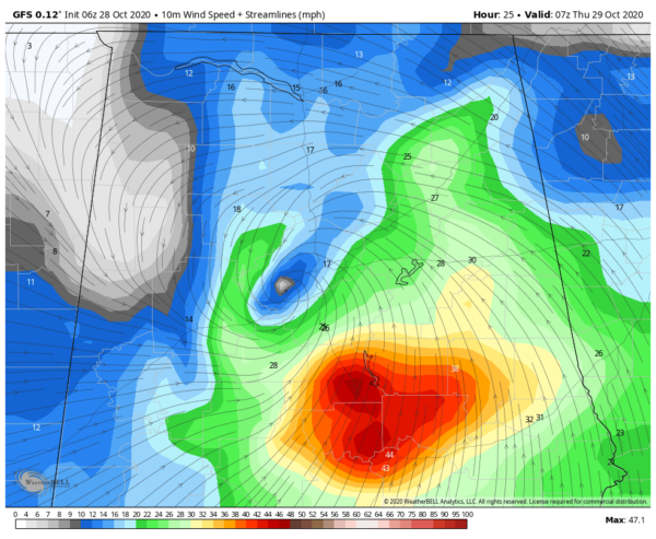
By 2 a.m.:
By 4 a.m. the circulation is getting ready to exit the state:
Here are peak winds expected county by county and timing:
Washington County (Chatom)…Sustained 65 mph, with gusts to 79 mph
Tropical storm force between 6:30 p.m. and 11:30 p.m.
Peak winds 9-10:30 p.m.
Mobile County (Mobile)…Sustained 61 mph, with gusts to 79 mph
Tropical storm force between 5 p.m. and 10:30 p.m.
Peak winds 8-9 p.m.
Clarke County (Grove Hill)…Sustained 61 mph, with gusts to 74 mph
Tropical storm force between 7:30 p.m. – midnight
Peak winds 10:30 p.m.
Marengo County (Demopolis)…Sustained 60 mph, with gusts to 73 mph
Tropical storm force between 9 p.m. and 1 a.m.
Peak winds 11:30 p.m.
Perry County (Marion)…Sustained 58 mph, with gusts to 70 mph
Tropical storm force between 10:30 p.m. and 1:30 a.m.
Peak winds 1 a.m.
Wilcox County (Camden)…Sustained 58 mph, with gusts to 70 mph
Tropical storm force between 9 p.m. and 1 a.m.
Peak winds: midnight
Dallas County (Selma)…Sustained 57 mph, with gusts to 68 mph
Tropical storm force between 10 p.m. and 1:30 a.m.
Peak winds 12:30 a.m.
Choctaw County (Butler)…Sustained 56 mph, with gusts to 68 mph
Tropical storm force between 8:30 p.m. and 11:30 p.m.
Peak winds 10:30 p.m.
Bibb County (Brent)…Sustained 56 mph, with gusts to 68 mph
Tropical storm force between 11:30 p.m. and 2 a.m.
Peak winds 1:30 a.m.
Hale County (Greensboro)…Sustained 56 mph, with gusts to 66 mph
Tropical storm force between 10:30 p.m. and 1 a.m.
Peak winds 12:30 a.m.
Monroe County (Monroeville)…Sustained 55 mph, with gusts to 66 mph
Tropical storm force between 10 p.m. and 12:30 a.m.
Peak winds 11 p.m.
Monroe County (Monroeville)…Sustained 55 mph, with gusts to 66 mph
Tropical storm force between 10 p.m. and 12:30 a.m.
Peak winds 11 p.m.
Baldwin County (Fairhope)…Sustained 54 mph, with gusts to 65 mph
Tropical storm force between 6 p.m. and 10:30 p.m.
Peak winds 9 p.m.
Shelby County (Columbiana)…Sustained 53 mph, with gusts to 64 mph
Tropical storm force between 12:30 a.m. and 2:30 a.m.
Peak winds 2 a.m.
Talladega County (Talladega)…Sustained 52 mph, with gusts to 63 mph
Tropical storm force between 1 a.m. and 3 a.m.
Peak winds 2:30 a.m.
Autauga County (Prattville)…Sustained 51 mph, with gusts to 61 mph
Tropical storm force between 11 p.m. and 2 a.m.
Peak winds 1 a.m.
Chilton County (Clanton)…Sustained 51 mph, with gusts to 62 mph
Tropical storm force between 11:30 p.m. and 2:30 a.m.
Peak winds 1 a.m.
Cleburne County (Heflin)…Sustained 50 mph, with gusts to 61 mph
Tropical storm force between 2:30 a.m. and 4 a.m.
Peak winds 3:30 a.m.
Clay County (Ashland)…Sustained 49 mph, with gusts to 59 mph
Tropical storm force between 1:30 a.m. and 3:30 a.m.
Peak winds 3 a.m.
Lowndes County (Hayneville)…Sustained 49 mph, with gusts to 59 mph
Tropical storm force between 10:30 p.m. and 1:30 a.m.
Peak winds 12:30 a.m.
Escambia County (Brewton)…Sustained 49 mph, with gusts to 59 mph
Tropical storm force between 8 p.m. and 12:30 p.m.
Peak winds 10:30 p.m.
Calhoun County (Anniston)…Sustained 49 mph, with gusts to 60 mph
Tropical storm force between 2 a.m. and 3:30 a.m.
Peak winds 3 a.m.
Coosa County (Rockford)…Sustained 48 mph, with gusts to 59 mph
Tropical storm force between 12:30 a.m. and 3 a.m.
Peak winds 2 a.m.
Conecuh County (Evergeen)…Sustained 48 mph, with gusts to 59 mph
Tropical storm force between 8:30 p.m. and 12;30 a.m.
Peak winds 10:30 p.m.
St. Clair County (Pell City)…Sustained 47 mph, with gusts to 57 mph
Tropical storm force between 1:30 a.m. and 2:30 a.m.
Peak winds 2:30 a.m.
Butler County (Greenville)…Sustained 46 mph, with gusts to 56 mph
Tropical storm force between 10 p.m. and 1 a.m.
Peak winds 11:30 p.m.
Tallapoosa County (Dadeville)…Sustained 46 mph, with gusts to 55 mph
Tropical storm force between 1:30 a.m. and 3 a.m.
Peak winds 2:30 a.m.
Randolph County (Wedowee)…Sustained 46 mph, with gusts to 56 mph
Tropical storm force between 2 a.m. and 3:30 a.m.
Peak winds 3 a.m.
Elmore County (Rockford)…Sustained 45 mph, with gusts to 55 mph
Tropical storm force between 12:30 a.m. and 2:30 a.m.
Peak winds 2 a.m.
Jefferson County (Hoover)…Sustained 44 mph, with gusts to 53 mph
Tropical storm force between 1 a.m. and 2 a.m.
Peak winds 1:30 a.m.
Cherokee County (Piedmont)…Sustained 43 mph, with gusts to 52 mph
Tropical storm force between 3 a.m. and 4 a.m.
Peak winds 3:30 a.m.
Chambers County (Lafayette)…Sustained 43 mph, with gusts to 52 mph
Tropical storm force between 3 a.m. and 4 a.m.
Peak winds 3:30 a.m.
Montgomery County (Montgomery)…Sustained 43 mph, with gusts to 52 mph
Tropical storm force between 11:30 p.m. and 2 a.m.
Peak winds 1 a.m.
Sumter County (Livingston)…Sustained 41 mph, with gusts to 50 mph
Tropical storm force between 10:30 p.m. and 11:30 p.m.
Peak winds 11 p.m.
Greene County (Eutaw)…Sustained 41 mph, with gusts to 50 mph
Tropical storm force between 11 p.m. to midnight
Peak winds 11:30 p.m.
Tuscaloosa County (Tuscaloosa)…Sustained 41 mph, with gusts to 50 mph
Tropical storm force between 12:30 a.m. and 1:30 a.m.
Peak winds 1 a.m.
Crenshaw County (Luverne)…Sustained 41 mph, with gusts to 49 mph
Tropical storm force between 11 p.m. and 1 a.m.
Peak winds midnight
Etowah County (Gadsden)…Sustained 40 mph, with gusts to 49 mph
Tropical storm force between 2 a.m. and 3 a.m.
Peak winds 2:30 a.m.
Macon County (Tuskegee)…Sustained 40 mph, with gusts to 49 mph
Tropical storm force between 1:30 a.m. and 2:30 a.m.
Peak winds 2 a.m.
Lee County (Auburn)…Sustained 40 mph, with gusts to 48 mph
Tropical storm force briefly around 2:30 a.m.
Covington County (Andalusia)…Sustained 39 mph, with gusts to 48 mph
Tropical storm force briefly around 11:30 p.m.
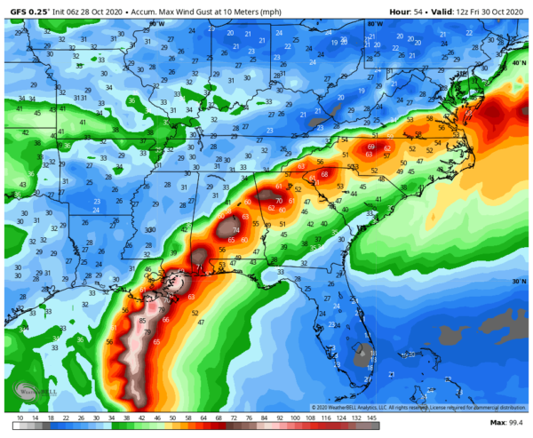
Everyone else should be below tropical storm force as far as sustained winds go. Winds will gust to above 40 mph across a wide rea though. Here are accumulated wind gusts off the GFS:
Category: Alabama's Weather, ALL POSTS, Tropical

