Potential High Impact Wind Event For Alabama Tonight
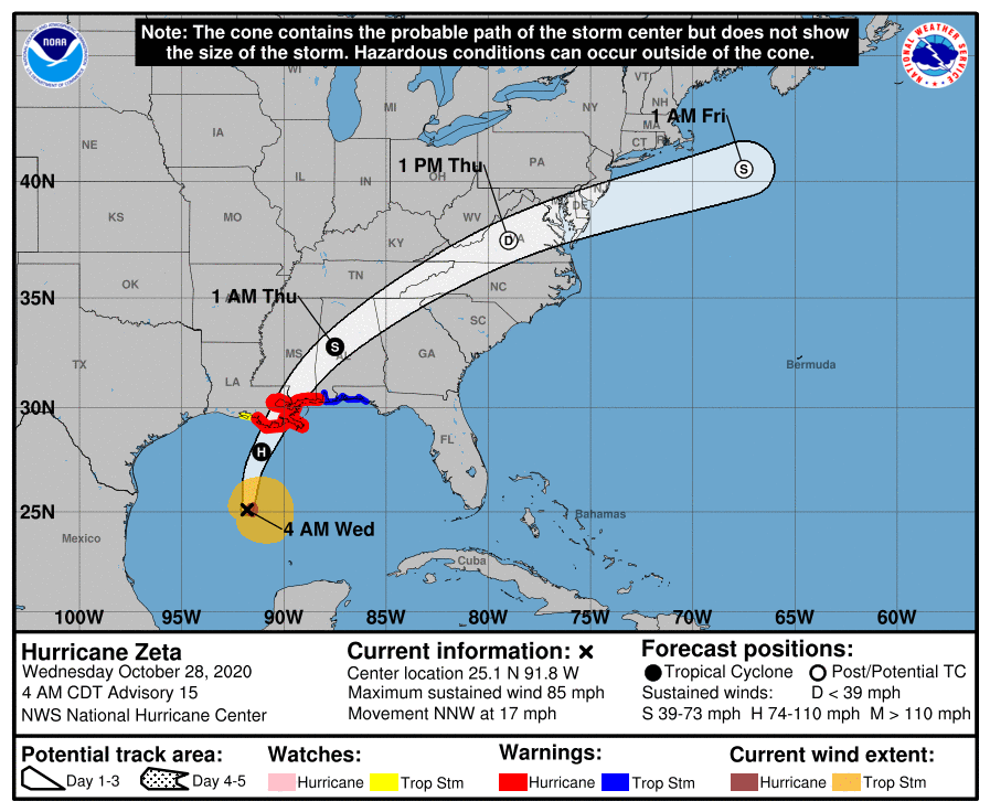
ZETA APPROACHING: Zeta is a hurricane again early this morning in the Gulf of Mexico with winds of 85 mph. It will move into Southeast Louisiana late this afternoon, and race rapidly through Alabama tonight.
We will deal with periods of rain today with temperatures in the 70s; the main wind and rain associated directly with Zeta will come tonight, and there is potential for a high impact wind event for much of the state.
GULF COAST: Zeta is expected to bring a storm surge of 6-9 feet for Dauphin Island, 4-6 feet for Mobile Bay, and 3-5 feet for Fort Morgan, Gulf Shores, and Orange Beach. Winds over Mobile and Baldwin counties could gust to 70 mph in spots this evening; a tropical storm warning is in effect. A few isolated tornadoes or waterspouts are possible this afternoon and early tonight.
INLAND ALABAMA: A tropical storm watch covers much of Central and Northeast Alabama, where the core of Zeta will be moving through late tonight. That watch will be upgraded to a tropical storm warning a little later this morning. Remember, tropical storm force winds are 39-73 mph.
Due to the rapid movement of the system, Zeta won’t have much time to weaken over inland Alabama. And, that fast forward motion will also add to the wind potential of the system. Accordingly, this now looks like it has potential to be a high impact wind event for inland parts of Alabama late tonight; sustained winds of 25-45, with gusts to 65 mph in a few places south of I-59. This will bring the potential for significant tree and power line damage to much of the state late tonight.
*The core of the highest wind for Central and Northeast Alabama will come from midnight to 6am. And, the higher winds will be along and south of I-59.
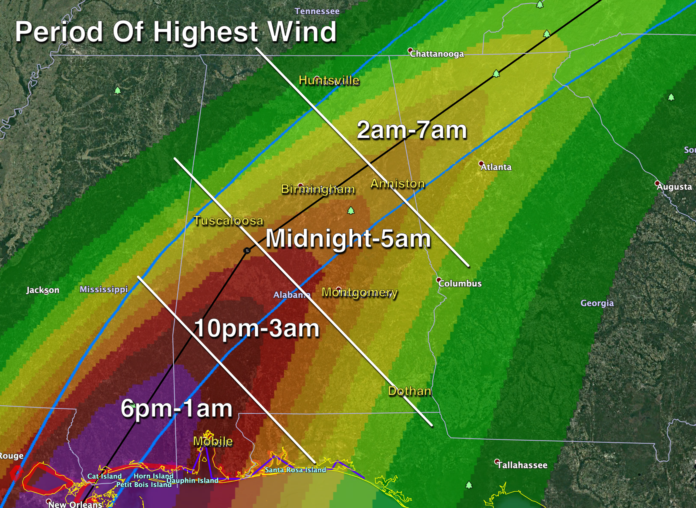
*For any one spot, the highest winds will last about 2-3 hours.
*The greatest concern will come from falling trees late tonight and during the pre-dawn hours tomorrow. If you live in a mobile home surrounded by pine trees, I would consider spending the night in a different place tonight.
*Plan now for power outages.
*A few isolated brief tornadoes are possible overnight as well; the highest risk will come over the southern half of the state.
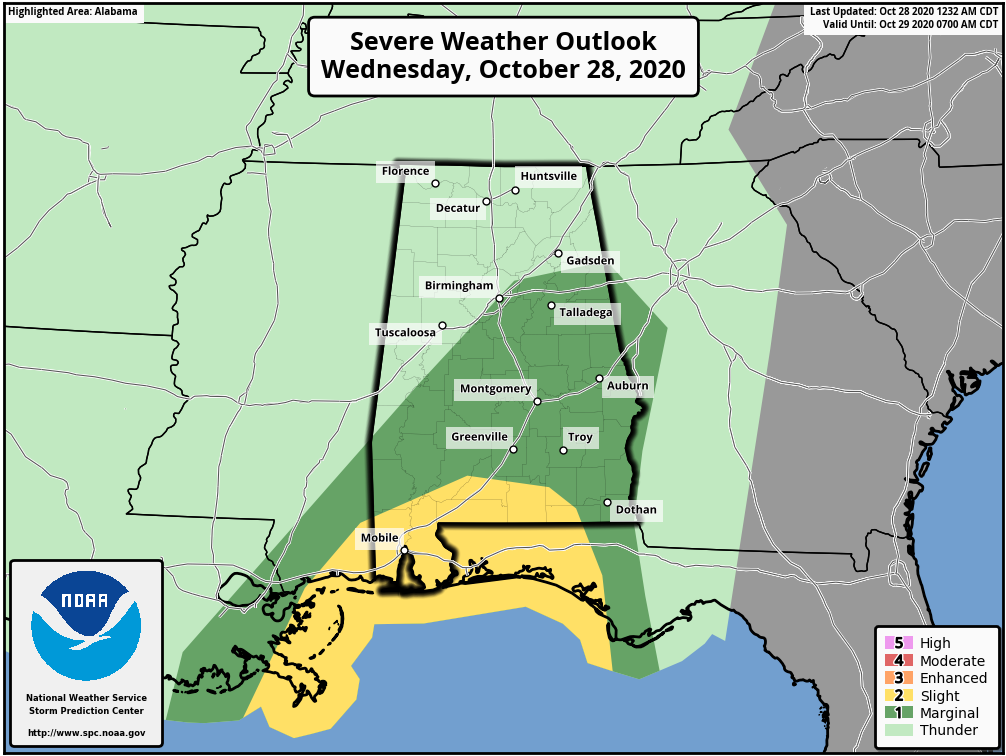
*Rain amounts over the next 24 hours will be in the 1-3 inch range; a flash flood watch is in effect for much of Central and Southwest Alabama.
*The wind and the rain will subside early tomorrow morning, and the sky becomes partly sunny during the day tomorrow.
Since this is considerable forecast change (in terms of the wind situation) from 24-36 hours ago, be sure your friends and neighbors know about the threat late tonight.
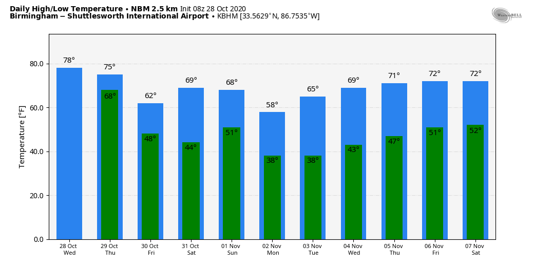
FRIDAY AND THE WEEKEND: We are forecasting fine fall weather Friday through the weekend with mostly sunny pleasant days and fair cool nights. The high Friday will be in the mid 60s, followed by highs between 68 and 72 over the weekend. Lows will be mostly in the 40s.
NEXT WEEK: Colder air arrives Monday, we start the day in the mid to upper 30s, followed by a high only in the upper 50s. Some North Alabama communities could see a freeze early Tuesday morning, with lots of frost elsewhere. The high Tuesday will be in the 60s, and the latter half of the week still looks rain-free with pleasant temperatures. See the Weather Xtreme video for maps, graphics, and more details.
ON THIS DATE IN 1999: A Super Typhoon, known as Cyclone 05B reached the equivalent of the Category 5 hurricane on this day. This storm is the strongest tropical cyclone ever record in the North Indian Ocean. Cyclone 05B hit the Indian State of Odisha near the city of Bhubaneswar on October 29. An estimated 10,000 individuals would die from this cyclone, and 1.67 million people were left homeless.
BEACH FORECAST: Click here to see the AlabamaWx Beach Forecast Center page.
WEATHER BRAINS: Don’t forget you can listen to our weekly 90 minute show anytime on your favorite podcast app. This is the show all about weather featuring many familiar voices, including our meteorologists here at ABC 33/40.
CONNECT: You can find me on all of the major social networks…
Facebook
Twitter
Instagram
Pinterest
Snapchat: spannwx
Look for the next Weather Xtreme video here by 4:00 this afternoon… enjoy the day!
Category: Alabama's Weather, ALL POSTS, Weather Xtreme Videos
About the Author (Author Profile)
James Spann is one of the most recognized and trusted television meteorologists in the industry. He holds the AMS CCM designation and television seals from the AMS and NWA. He is a past winner of the Broadcast Meteorologist of the Year from both professional organizations.Subscribe
If you enjoyed this article, subscribe to receive more just like it.


