Weather Xtreme: No Frightening Weather for Halloween… or Through the Next Seven Days
THE CENTRAL ALABAMA WEEKEND
SATURDAY: At the surface, we’ll have high pressure located just off to our northeast that will keep us dry and cool throughout Central Alabama. Skies will be mostly sunny throughout much of the day, but some clouds do move in late. Highs will top out in the mid-60s to the lower 70s. Don’t forget to set those clocks back an hour before heading to bed.
SUNDAY: We’ll start off with some cloud cover, but those clouds will move out quickly and we’ll have sunny skies by the late morning. It will be a very nice day with highs reaching the lower 60s to the lower 70s. A cold front will move through during the day that will bring a reinforcing shot of cooler air, but you’ll notice it pass by as winds will become a little breezy and cooler out of the north.
THE WORK WEEK AHEAD
MONDAY: High pressure builds into our west to start the work week and we’ll be very cool with sunny skies. Morning lows will be chilly ranging from the lower 30s to the lower 40s, so some locations may see some frost or a brief light freeze. Highs will only make it into the mid-50s to the lower 60s.
TUESDAY: Election Day 2020 will be another very nice but cool day across Central Alabama. After another chilly start, daytime highs will make it into the 60s across the area.
WEDNESDAY: High pressure build back in control off to our east which will keep our weather nice and quiet on Wednesday and through the end of the workweek. Highs will be in the upper 60s to the lower 70s with plenty of sunshine.
THURSDAY: We do notice a tropical system moving across the Caribbean Sea and some moisture will try to work into the southeast, but that high will keep everything to our south and southeast. We’ll be dry and mild with partly cloudy skies. Highs will be in the upper 60s to the mid-70s.
FRIDAY: We’ll continue to have some clouds at times on Friday, but the air looks to remain dry enough to keep any rain from forming across Central Alabama. Highs will be in the lower to mid-70s. We do note that the tropical system does begin to ever so slightly move northward. No threat to Central Alabama at this point, but we’ll have to keep an eye out on it.
THE TROPICS
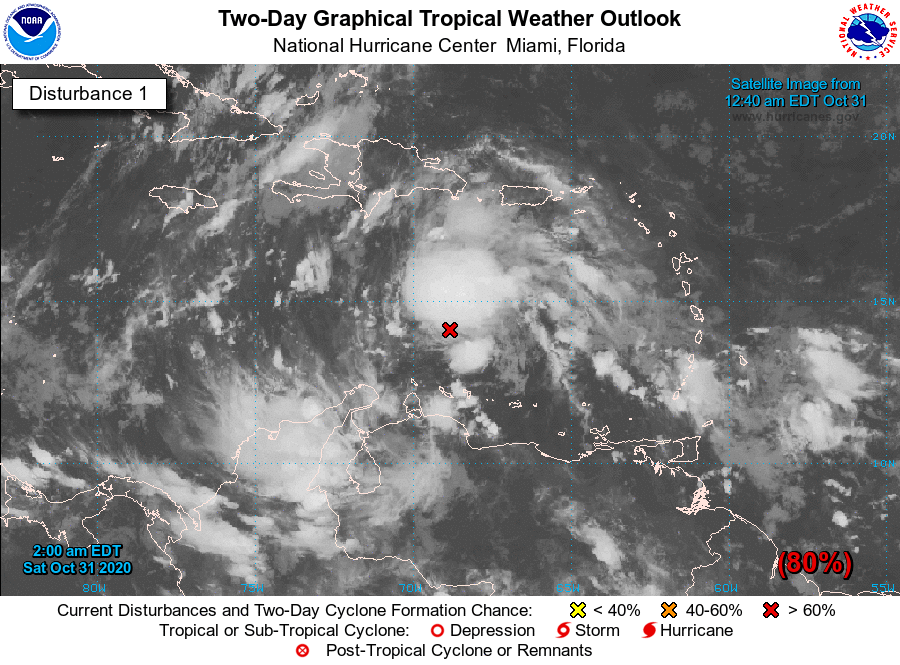
INVEST 96L: The disturbance over the Caribbean Sea, designated as Invest 96L, looks very impressive and organized as of 2:00 am and the environment continues to be supportive for further development. A tropical depression should form within the next 24 hours and will bring wind and rain to portions of the ABC islands and Jamaica through the weekend. Nearly all ensemble members have 96L moving west through the weekend and into the early parts of the workweek, then the members just go haywire. We do note that a few take the system northward into the Gulf of Mexico. Intensity guidance does have it strengthening into at least a tropical storm, which would be Eta. A few do have it making it into a hurricane. It’s too early in the game to be certain, but we’ll get a better idea once it becomes a depression and become even better organized.
Remember, the Atlantic Hurricane Season does not end until November 30th… still, one month to go.
ON THIS DATE IN WEATHER HISTORY
1846 – Eighty-seven pioneers were trapped by early snows in the Sierra Nevada Mountains that piled five feet deep, with 30 to 40 foot drifts. Just 47 persons survived the “Donner Pass Tragedy”.
BEACH FORECAST CENTER
Get the latest weather and rip current forecasts for the beaches from Dauphin Island, AL, to Panama City Beach, FL, on our Beach Forecast Center page. There, you can select the forecast of the region that you are interested in.
ADVERTISE ON THE BLOG!
We had another fantastic year in 2019 with just over 17 million page views! That brings our total for the last two years close to 37 million page views! At this point, we are already close to eclipsing the 2019 total. Don’t miss out! We can customize a creative, flexible, and affordable package that will suit your organization’s needs. Contact Bill Murray at (205) 687-0782.
E-FORECAST
Get the Alabama Wx Weather Blog’s Seven-Day Forecast delivered directly to your inbox by email twice daily. It is the most detailed weather forecast available in Central Alabama. Subscribe here… It’s free!
CONNECT WITH THE BLOG ON SOCIAL MEDIA
You can find the AlabamaWx Weather Blog on the major social media networks:
Facebook
Twitter
Instagram
WEATHERBRAINS
There are several ways to watch or listen to the podcast that is all about the weather. Watch live starting at 8:00 pm CT on Monday nights at live.bigbrainsmedia.com, James Spann’s Youtube Channel, or on one of ABC 3340’s digital weather channels (17.2, 40.2, 68.3). Listen to the recorded audio podcast at WeatherBrains.com or on your favorite podcast platform (Apple Podcasts, Stitcher, Spotify, etc.), or watch the recorded video on James Spann’s Youtube channel.
Category: Alabama's Weather, ALL POSTS, Tropical, Weather Xtreme Videos, Winter Weather
About the Author (Author Profile)
Scott Martin is an operational meteorologist, professional graphic artist, musician, husband, and father. Not only is Scott a member of the National Weather Association, but he is also the Central Alabama Chapter of the NWA president. Scott is also the co-founder of Racecast Weather, which provides forecasts for many racing series across the USA. He also supplies forecasts for the BassMaster Elite Series events including the BassMaster Classic.Subscribe
If you enjoyed this article, subscribe to receive more just like it.


