Sunday Weather Xtreme: Eta Uncertainty, Warm Week Ahead
TROPICAL STORM ETA will be turning to the northwest today after emerging off the north coast of Cuba. It will be over warm water which should allow it to maintain strong tropical storm intensity, around 70 mph until it reaches the Florida Keys late tonight. The storm will then emerge into the southeastern Gulf of Mexico on Monday where it will slow down and turn gradually to the northeast, eventually crossing the Florida Peninsula.
IMPACT ON THE GULF COAST: There are multiple alternatives that may occur with Eta, all of which have some differences in the impact on the beautiful beaches of Alabama and Northwest Florida. Option 1 turns the storm to the northeast over the Florida Panhandle near I-4. This would produce little impact except for higher rip current risks later in the week for beaches from Panama City eastward, along with a few showers, and some gusty winds over eastern sections. Option 2 brings a dissipating system to the northern Gulf Coast between Mobile and Panama City, which would lead to gusty winds and showers along the coast.
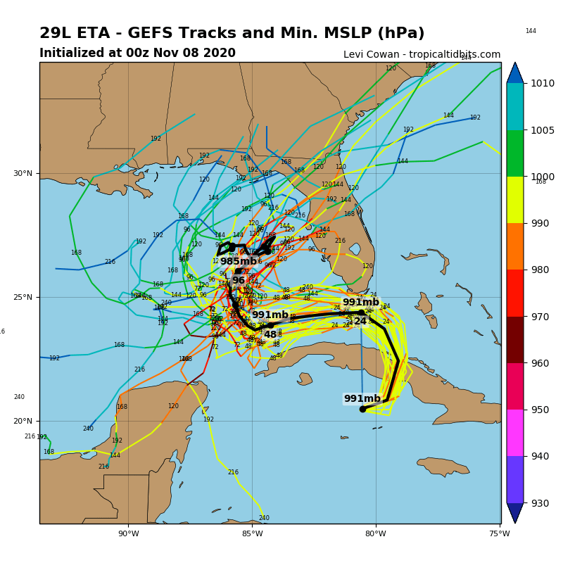
A BIG HEAPING PLATE OF SPAGHETTI: Here are the GFS ensemble member tracks for Eta. Confusing? To say the least.
CENTRAL ALABAMA IMPACT: Option 1 will just give us some gusty winds and clouds along with a few showers over southeastern sections. Option 2 could give us heavier rain and some gusty winds. But the weather will not be tremendously impactful, which is good news.
THE WEEK AHEAD: Clouds will hang touch into Monday, but it should remain dry. Tuesday will feature a few showers as moisture levels rise and lift increases ahead of an approaching front. Veterans Day will feature a few more showers and an isolated storm as the front makes further progress into the area. Thursday will be mostly dry as the front edge well south of I-59. Then Friday will feature more showers and storms as the circulation of Eta spreads moisture up and over the front, which will be retreating to the northwest ahead of the circulation.
WEEKEND OUTLOOK: Saturday will start out nice, with increasing clouds late in the day ahead of another front. This one will bring showers and storms late Saturday night into Sunday. That should lead to an extended period of nice and cooler weather into the following week.
VOODOO TERRITORY: Another weakening front will move through around Thursday the 19th with some showers and storms. The week of Thanksgiving should start off cool and dry.
BEACHCAST: Everything kind of depends on the future intensity and track of Eta. For now, it looks like showers Tuesday and Wednesday, with heavier rain Thursday and Friday along the beautiful beaches of Alabama and Northwest Florida. The rip current risk is presently high along the beaches of Alabama and Northwest Florida, and it will increase again later this week. Winds will be increasingly gusty by late Monday night into Tuesday and continuing for much of the rest of the week. Water temperatures are in the upper 60s.
Click here to see the Beach Forecast Center page.
ADVERTISE WITH US: Deliver your message to a highly engaged audience by advertising on the AlabamaWX.com website. The site enjoyed over 20 MILLION pageviews in the past 12 months. Don’t miss out! We can customize a creative, flexible and affordable package that will suit your organization’s needs. Contact me, Bill Murray, at (205) 687-0782 and let’s talk.
WEATHERBRAINS: This week, the panel will entertain National Weather Service Executive Officer Jamie Morrow. It will be a fun and entertaining show. Check out the show at www.WeatherBrains.com. You can also subscribe on iTunes. You can watch the show live at live.bigbrainsmedia.com or on James’ YouTube Channel You will be able to see the show on the James Spann 24×7 weather channel on cable or directly over the air on the dot 2 feed.
ON THIS DATE IN 1914: It finally rained on this date in Bagdad, California, breaking an incredible rain-free streak of 767 days, the U.S. record! Follow my weather history tweets on Twitter. I am @wxhistorian at Twitter.com.
Category: Alabama's Weather, ALL POSTS, Tropical
About the Author (Author Profile)
Bill Murray is the President of The Weather Factory. He is the site's official weather historian and a weekend forecaster. He also anchors the site's severe weather coverage. Bill Murray is the proud holder of National Weather Association Digital Seal #0001 @wxhistorianSubscribe
If you enjoyed this article, subscribe to receive more just like it.


