Sunday Weather Xtreme: Rain, Some Storms Today, Much Colder Starting Tomorrow
FOR YOUR SUNDAY: Today is getting off to a mostly cloudy start across the area with just a little sunshine remaining over northeastern sections. Temperatures that are in the 40s and lower 50s will warm into the upper 50s north to middle 60s over Central Alabama by afternoon. Rain showers will spread into southwestern Alabama this morning and spread northeastward across the state during the day. II will be breezy during the day, with southeasterly winds gusting to 15 mph at times into the early afternoon.
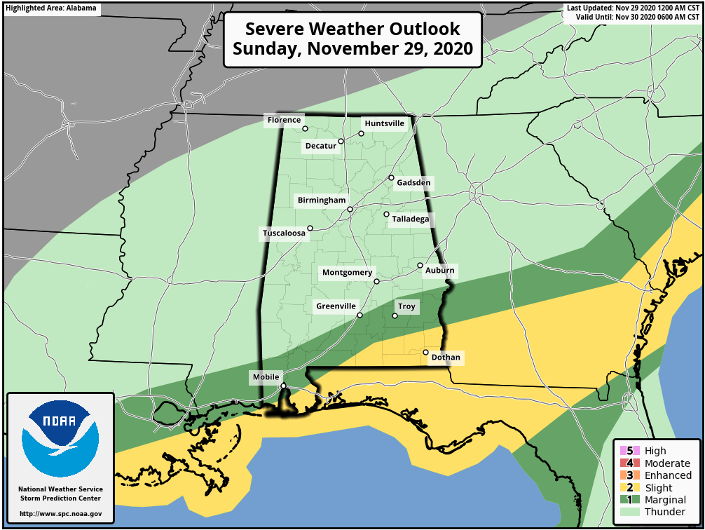
By late afternoon, intensifying low pressure will be approaching the Alabama border and winds will become ever gustier, reaching 25 mph at times through the evening. Convection will increase in the warm sector of the low into Southwest and South-Central Alabama by late afternoon into the evening, but instability will be limited to non-existent except near and south of the marine warm front which probably won’t make it very far into South Alabama. There will be sufficient bulk shear for organized storms if decent instability can develop.
The rain and storms will spread northeastward across the state through the evening hours. The precipitation should be out of the state during the predawn hours. As the low passes, winds will shift to the northwest and will continue to gust to 25 mph through the overnight hours. By dawn, readings will be in the upper 30s over North Alabama, with 40s elsewhere.
A RAW MONDAY: Monday will be the most miserable day that we have had in some time. For most areas, the temperature at midnight will be the high temperature for the day with slowly falling readings throughout the morning and afternoon. Throw in mostly cloudy skies, a gusty northwest wind, and a few spits and sputters of sprinkles or snowflakes and you have the makings of a not so nice day. Readings will be in the 30s across the northern half of the state by 3 p.m.
WIDESPREAD FREEZE MONDAY NIGHT: This will set the stage for a cold night Monday night. Skies will clear during the overnight hours and winds should gradually lie down as well. By early morning, lows will range from between 21-24F over North Alabama, to between 23-27F over Central Alabama, to upper 20s to the South. This should result in a widespread killing freeze.
TUESDAY/WEDNESDAY: Tuesday and Wednesday will feature partly cloudy skies with chilly temperatures. Many areas won’t get out of the 30s on Tuesday and 40s on Wednesday. Tuesday night lows will be in the lower and middle 20ss again.
NEXT WEATHER MAKER: By Thursday, a new low-pressure center will be near Houston once again, with southerly winds pumping warmth and moisture up into Alabama. Clouds will be on the increase Thursday and showers will arrive late Thursday afternoon and Thursday night. Rain will increase into Friday as a slow-moving front pushed into the state from the west. It will take all day and all-night Friday and Friday night to push the precipitation out of the state as a big, cold, lumbering upper-level low meanders across the state on Saturday.
WEEKEND: Expect some leftover clouds over northeastern sections on Saturday, with clearing skies elsewhere. Sunday should be sunny and cool with highs in the lower 50s.
VOODOO COUNTRY: A couple of fast-moving systems bring rain on Saturday the 12th and Monday the 14th.
BEACHCAST: Wet tonight into early Monday along the beautiful beaches of Alabama and Northwest Florida. It will be dry until Thursday when the next weather maker will affect the Gulf coast as well. It will turn much cooler early in the week, with highs in the 50s Tuesday and 60s remainder of the week. Lows will be near freezing Tuesday and Wednesday mornings but moderating for the remainder of the week. There will be a high rip current risk through Monday. Water temperatures are in the lower 70s.
Click here to see the Beach Forecast Center page.
DANCING WITH THE STATS: Record high at Brownsville, Texas yesterday with 88F.
NEWS AND NOTES: Beginning Thursday, December 3rd, the Columbus Air Force Base (KGWX) WSR-88D radar will go offline for the next phase of the WSR-88D Service Life Extension Program (SLEP). The radar will be down for approximately seven days.
ADVERTISE WITH US: Deliver your message to a highly engaged audience by advertising on the AlabamaWX.com website. The site enjoyed 20 MILLION page views in the past 12 months. Don’t miss out! We can customize a creative, flexible, and affordable package that will suit your organization’s needs. Contact me, Bill Murray, at (205) 687-0782, and let’s talk.
WEATHERBRAINS: This week, the panel will entertain Barb Mayes Boustead, a Civil Servant Federal Scientist and Meteorological Instructor for NOAA’s National Weather Service, Barb Mayes Boustead. She’s pretty fascinating. Check out the show at www.WeatherBrains.com. You can also subscribe on iTunes. You can watch the show live at live.bigbrainsmedia.com or on James’ YouTube Channel You will be able to see the show on the James Spann 24×7 weather channel on cable or directly over the air on the dot 2 feed.
ON THIS DATE IN 2013: A magnitude 7.2 earthquake off the coast of the island of Hawaii produced a tsunami that killed 2 campers and injured another 19 at Halape Park. The earthquake caused rocks to be loosened from a hillside above the park, and this caused the campers to move to a coconut grove closer to the ocean. The first tsunami-generated wave was only 1.5 meters high, but the second was 7.9 meters and swept many of the campers away. By the time local authorities sounded the tsunami warning sirens, the wave had already struck. As in most cases of locally generated tsunamis, the best warning signal is the earthquake itself. Follow my weather history tweets on Twitter. I am @wxhistorian at Twitter.com.
Category: Alabama's Weather, ALL POSTS
About the Author (Author Profile)
Bill Murray is the President of The Weather Factory. He is the site's official weather historian and a weekend forecaster. He also anchors the site's severe weather coverage. Bill Murray is the proud holder of National Weather Association Digital Seal #0001 @wxhistorianSubscribe
If you enjoyed this article, subscribe to receive more just like it.


