Saturday’s Weather Xtreme: Staying Dry Through Tuesday; Rain & Storms Move In On Hump Day
A Rather Nice After-Christmas Weekend
High pressure will rule the weather over the Southeastern US on Saturday which will give up maximum sunshine and afternoon highs reaching the upper 40s to the lower 50s across Central Alabama. Increasing high pressure moves to our east a little on Sunday which will only change our weather by making afternoon highs much warmer. We’ll make it into the mid to upper 50s across the area.
A Quiet Start to the Week, But Not That Bright
A weak cold front will move across the area on Monday which will bring clouds to the area, but at this point, the models are keeping moisture out of the mix, and we’ll stay dry throughout the day. Highs will be in the lower 50s to the mid-60s across the area from north to south.
The cold front makes into south Alabama on Tuesday but there will not be much change in the weather. Skies will stay mostly cloudy and afternoon highs will be in the lower 50s to the lower 60s.
A Soaker Moves In For Wednesday & Thursday
A strong low will be moving across the Great Lakes region and into Canada throughout the day on Wednesday that will be dragging another cold front into and across Central Alabama. This time, there will be plenty of moisture associated with this front, and there will be just enough instability for some thunder. A little early to call for the potential of severe storms, but with the better dynamics being so far away, that potential looks very, very small. Activity looks to move in starting in the late afternoon hours and continue for the remainder of the day. Highs before the front moves in will be in the upper 50s to the mid-60s.
Rain and storms will continue through the morning and into the early afternoon hours on Thursday, but those will begin to move out of the area by the mid to late afternoon through the evening hours. Cold air will move back in behind the front and rain, but temperatures will not be as cold as we have seen on Christmas night. We could see a few flurries on the backside of the system, but they will probably end up being less than what we saw on Christmas Eve. Highs will be in the mid-40s to the upper 50s.
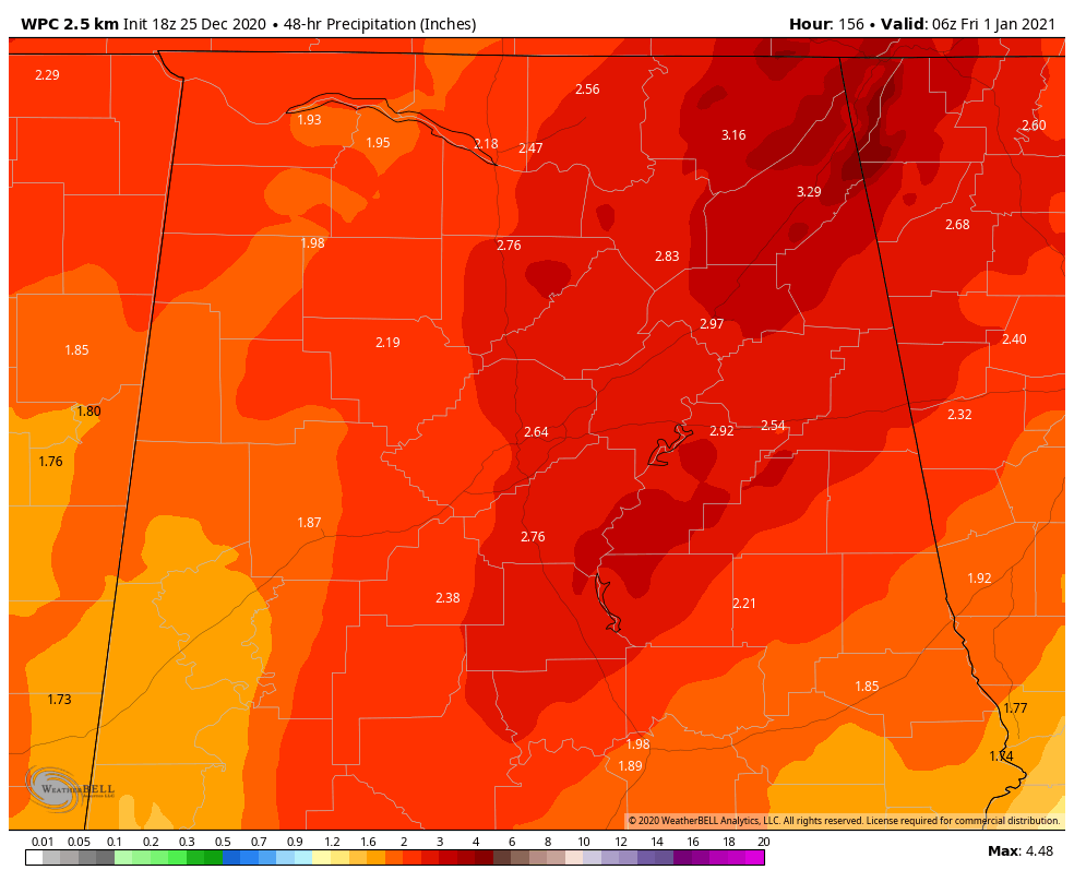
48-hour rainfall totals that are being projected from the WPC show a good soaker for the area as the potential of 2-3 inches of rainfall could fall on Wednesday and Thursday.
Nice But Cool For New Year’s Day
Clouds will continue to decrease across the area on Friday with skies becoming mostly sunny early on. Temperatures will start off in the upper 20s to the mid-30s, but will eventually climb into the mid-40s to the lower 50s for afternoon highs.
Today In Weather History
1776: George Washington crossed the ice clogged Delaware River. He marched on Trenton in the midst of snow and sleet thus surprising and capturing many of the British garrison.
1778: The “Hessian Storm”, a severe blizzard, blasted the Northeast from Pennsylvania to New England. Snow drifts were reported as high as 16 feet in Rhode Island. The storm was named for troops occupying Rhode Island during the Revolutionary War.
Beach Forecast Center
Get the latest weather and rip current forecasts for the beaches from Dauphin Island, AL, to Panama City Beach, FL, on our Beach Forecast Center page. There, you can select the forecast of the region that you are interested in.
Advertise On The Blog!
We had another fantastic year in 2019 with just over 17 million page views! That brings our total for the last two years close to 37 million page views! At this point, we are already close to eclipsing the 2019 total. Don’t miss out! We can customize a creative, flexible, and affordable package that will suit your organization’s needs. Contact Bill Murray at (205) 687-0782.
E-Forecast
Get the Alabama Wx Weather Blog’s Seven-Day Forecast delivered directly to your inbox by email twice daily. It is the most detailed weather forecast available in Central Alabama. Subscribe here… It’s free!
Connect With The Blog On Social Media
You can find the AlabamaWx Weather Blog on the major social media networks:
Facebook
Twitter
WeatherBrains
There are several ways to watch or listen to the podcast that is all about the weather. Watch live starting at 8:00 pm CT on Monday nights at live.bigbrainsmedia.com, James Spann’s YouTube Channel, or on one of ABC 3340’s digital weather channels (17.2, 40.2, 68.3). Listen to the recorded audio podcast at WeatherBrains.com or on your favorite podcast platform (Apple Podcasts, Stitcher, Spotify, etc.), or watch the recorded video on James Spann’s YouTube channel.
Category: Alabama's Weather, ALL POSTS, Weather Xtreme Videos
About the Author (Author Profile)
Scott Martin is an operational meteorologist, professional graphic artist, musician, husband, and father. Not only is Scott a member of the National Weather Association, but he is also the Central Alabama Chapter of the NWA president. Scott is also the co-founder of Racecast Weather, which provides forecasts for many racing series across the USA. He also supplies forecasts for the BassMaster Elite Series events including the BassMaster Classic.Subscribe
If you enjoyed this article, subscribe to receive more just like it.


