Midday Nowcast: Rain North, Clouds Elsewhere
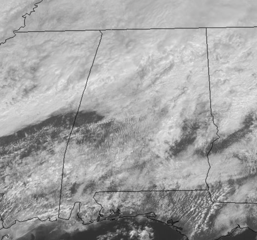
A meandering front across the state allowed for it to be a wet and stormy morning across North/Central Alabama, but as we get ready to enter the afternoon hours, things are winding down for most of us, but still some scattered showers will remain the forecast the rest of today.
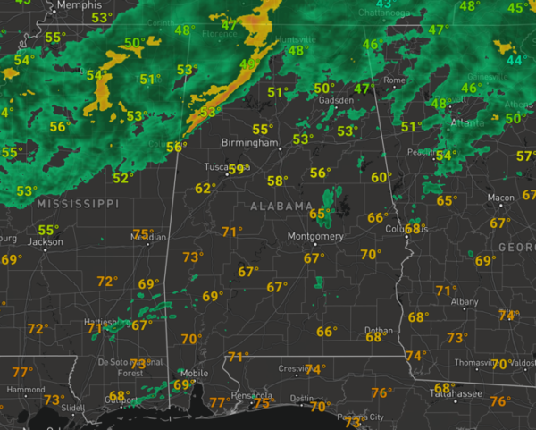
Heavy pockets of rain will continue across North Alabama. It remains mostly cloudy across the state with cool 50s for North Alabama, while 60s and 70s are common across Central and South Alabama.
WARM WEEKEND WEATHER: The front will hold in place over the Tennessee Valley of the state, where periods of rain are expected all weekend. For the rest of the state, it is shaping up to be the warmest weekend of 2021 so far as a warm, moist air mass surges north out of the Gulf. Both Saturday and Sunday will feature more clouds than sun, with the chance for scattered showers at times. Highs this weekend will range from the mid 70s to mid 80s from north to south, and there could even be some record highs set across South Alabama this weekend.
HELLO MARCH: We start meteorological spring off on a wet and stormy note across the state as the front sinks south into Central Alabama. Monday and Tuesday look to feature periods of rain and thunderstorms both days. The European model continues to hint that strong storms are a possibility by Tuesday evening, but it continues to be too early to determine if there will be a significant severe weather threat, and is something we will watch through the weekend. We are expecting heavy rain at times, with rain totals in the 2-4 inch range possible. Then, dry air begins to return Wednesday, and for now we expect dry weather Thursday and Friday. Highs through the week will be mostly in the 60s. Also, don’t forget that March is the first month in the heart of our spring severe weather season, so all systems will have to be monitored for the potential for severe weather. Now, it s a great time go over and review your severe weather plan and make sure you and your family are ready to act when severe weather threatens.
BEACH FORECAST CENTER: Get the latest weather and rip current forecasts for the beaches from Fort Morgan to Panama City on our Beach Forecast Center page. There, you can select the forecast of the region that you are interested in visiting.
WORLD TEMPERATURE EXTREMES: Over the last 24 hours, the highest observation outside the U.S. was 104.7F at Bhubaneswar, India. The lowest observation was -68.3F at Vostok, Antarctica.
CONTIGUOUS TEMPERATURE EXTREMES: Over the last 24 hours, the highest observation was 93F at Zapata, TX. The lowest observation was -19F at Big Black River and Nine Mile Bridge, ME.
WEATHER ON THIS DATE IN 1972: The Buffalo Creek disaster occurred in the Buffalo Creek Hollow of Logan County in West Virginia. A coal slag dam on the Middle Fork of Buffalo Creek burst sending a fifty foot wall of water down a narrow valley killing 125 persons and causing 51 million dollars damage. Three days of rain atop a six inches snow cover prompted the dam break.
Category: Alabama's Weather, ALL POSTS
About the Author (Author Profile)
Macon, Georgia Television Chief Meteorologist, Birmingham native, and long time Contributor on AlabamaWX. Stormchaser. I did not choose Weather, it chose Me. College Football Fanatic. @Ryan_StinnetSubscribe
If you enjoyed this article, subscribe to receive more just like it.


