Tornado Watch Extended to Include More Counties in Central Alabama
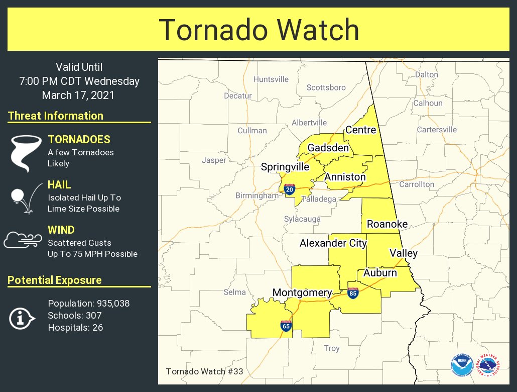
Counties included are: Calhoun, Chambers, Cherokee, Cleburne, Elmore, Etowah, Lee, Lowndes, Macon, Montgomery, Randolph, St. Clair, Tallapoosa.
The NWS Storm Prediction Center has issued a
* Tornado Watch for portions of
Central to eastern Alabama
* Effective this Wednesday afternoon and evening from 115 PM
until 700 PM CDT.
* Primary threats include…
A few tornadoes and a couple intense tornadoes likely
Scattered damaging winds and isolated significant gusts to 75
mph possible
Isolated very large hail events to 2 inches in diameter possible
SUMMARY…Discrete supercells across central Alabama may spread into
portions of eastern Alabama prior to early evening. All hazard types
are possible, with the greatest tornado threat expected in
east-central Alabama.
The tornado watch area is approximately along and 30 statute miles
east and west of a line from 30 miles east northeast of Gadsden AL
to 15 miles south southeast of Montgomery AL. For a complete
depiction of the watch see the associated watch outline update
(WOUS64 KWNS WOU3).
PRECAUTIONARY/PREPAREDNESS ACTIONS…
REMEMBER…A Tornado Watch means conditions are favorable for
tornadoes and severe thunderstorms in and close to the watch
area. Persons in these areas should be on the lookout for
threatening weather conditions and listen for later statements
and possible warnings.
Category: Alabama's Weather, ALL POSTS, Severe Weather
About the Author (Author Profile)
Scott Martin is an operational meteorologist, professional graphic artist, musician, husband, and father. Not only is Scott a member of the National Weather Association, but he is also the Central Alabama Chapter of the NWA president. Scott is also the co-founder of Racecast Weather, which provides forecasts for many racing series across the USA. He also supplies forecasts for the BassMaster Elite Series events including the BassMaster Classic.Subscribe
If you enjoyed this article, subscribe to receive more just like it.


